Hart County sits in south-central Kentucky, where Horse Cave, Munfordville, and Bonnieville form a clear north-south chain through the middle of the county. I-65 provides the most obvious transportation reference, while the Green River bends across the county near Munfordville and ties the area to the broader Mammoth Cave landscape. The maps on this page show roads, settlements, water features, and elevation, and the high-resolution JPG originals can be downloaded together in a ZIP file. High-resolution map files are available for download in the section below.
Two landmarks make Hart County easy to organize at first glance: Horse Cave near the southern edge and Munfordville near the Green River. Bonnieville continues the same general corridor to the north. Away from that central line, the western and northern sides become more irregular, with branching creeks, curved roads, and closely spaced ridges. That contrast between the I-65 corridor and the more broken surrounding terrain gives the county a distinctive shape on all four maps.
Table of Contents
I-65 links Horse Cave, Munfordville, and Bonnieville through the county
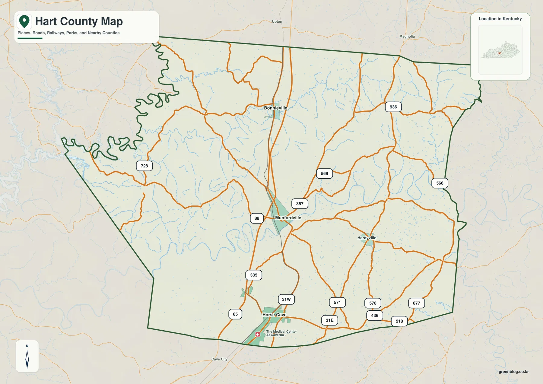
The county map makes I-65 the easiest line to follow. It enters near Horse Cave, continues north past Munfordville, and runs toward Bonnieville before leaving Hart County. U.S. 31W appears near Horse Cave, while U.S. 31E and routes such as KY 571, KY 570, KY 436, KY 218, and KY 677 are visible across the southern and southeastern part of the county. Near Munfordville, KY 88, KY 335, KY 357, and KY 569 branch toward surrounding communities and rural roads.
The outer parts of the county have a different road pattern. KY 728 reaches into the west, where the county boundary and valleys are much less regular, while KY 566 and KY 936 serve the northeastern side. The contrast is useful when reading the map: the central interstate corridor is comparatively direct, but local roads often bend with the hills and stream valleys. For current turn-by-turn travel, closures, or construction, a live navigation source should still be used.
Munfordville is the county seat and occupies a central position between Horse Cave and Bonnieville. Hardyville appears to the east, while Cave City lies just beyond the southern boundary. These nearby labels help place Hart County within the larger Cave Country region instead of treating the county boundary as an isolated frame. The dark county outline is especially useful on the west side, where the boundary follows a much more complicated shape than it does along the southern edge.
Horse Cave is the southern hub, with Munfordville seven miles away
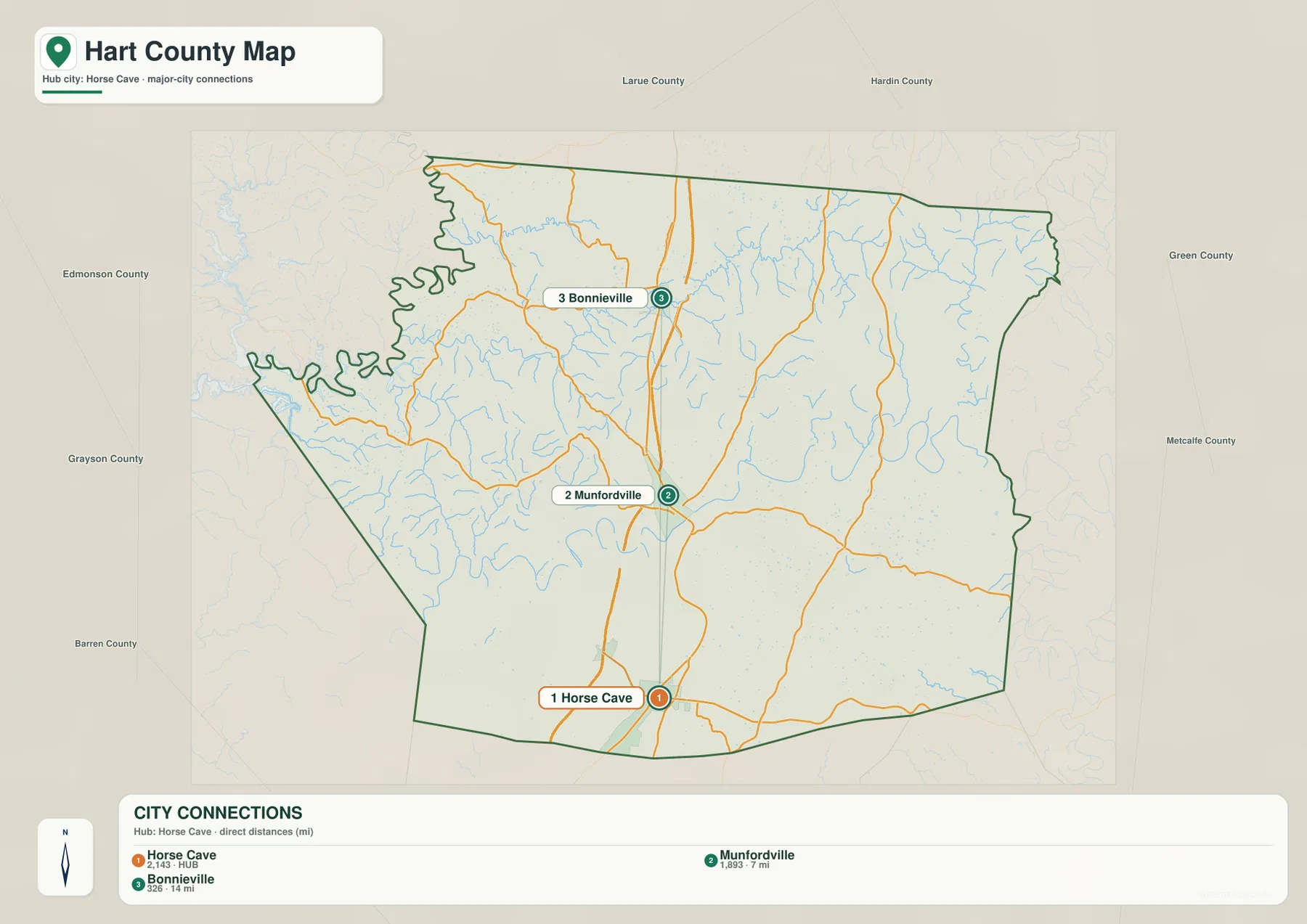
The city-connections map uses Horse Cave as the hub and reduces the county to three principal city references. Its labels show Horse Cave at 2,143, Munfordville at 1,893, and Bonnieville at 326. The same map gives direct distances of about 7 miles from Horse Cave to Munfordville and about 14 miles from Horse Cave to Bonnieville. Those values are best treated as map reference labels rather than live population statistics; current demographic totals should come from the latest Census releases.
The three cities sit close to the central transportation corridor, but their geographic settings differ. Horse Cave is near the southern county line and close to I-65 access. Munfordville lies farther north beside the Green River and serves as the county seat. Bonnieville is smaller, yet it gives the northern part of the county a clear named anchor. This arrangement helps explain why the middle of Hart County reads as a connected chain of settlements rather than one dominant city surrounded by empty space.
The western half of the county looks much less urban on the city map. There are few large settlement labels there, and the landscape is defined more by local roads, creeks, and ridges. That difference is useful when switching back to the detailed county map: a road that seems remote on the west side is not missing a major city label; it is passing through a more rural part of Hart County.
The Green River divides the county with a long chain of bends
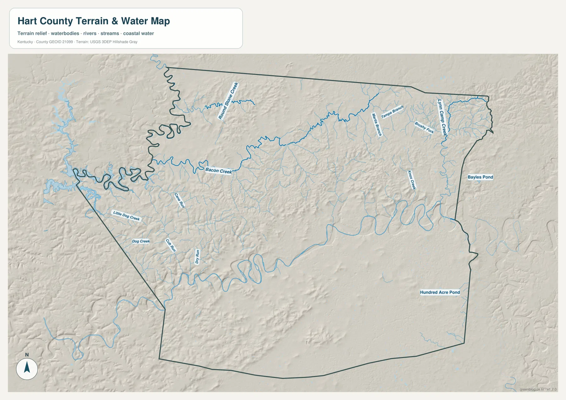
The Green River is the dominant water feature in Hart County. It winds across the middle of the county in a series of large bends and passes close to Munfordville, where the river has also played an important role in local transportation history. The Advisory Council on Historic Preservation notes that the nineteenth-century railroad bridge across the Green River at Munfordville became strategically important during the Civil War, adding a historical layer to the river corridor visible on the map.
Smaller waterways fill the surrounding terrain. Round Bottom Creek and Bacon Creek are labeled in the northwestern and western sections, while Little Dog Creek and Dog Creek drain nearby valleys. Farther east, Lynn Camp Creek, Brushy Fork, and Knob Creek appear among many smaller branches. Bayles Pond and Hundred Acre Pond provide additional named water references on the eastern side. Together, these features show how extensively short stream valleys cut the county away from the central river.
Hart County also belongs to the Mammoth Cave region. The Advisory Council on Historic Preservation states that part of Mammoth Cave National Park lies in the county, and local tourism information emphasizes caves, the Green River, trails, and heritage sites. The downloadable water map does not show underground cave passages or groundwater boundaries, so anyone planning a cave visit should rely on National Park Service and attraction-specific information for entrances, access rules, and current conditions.
Elevation ranges from 132 to 350 meters across river valleys and ridges
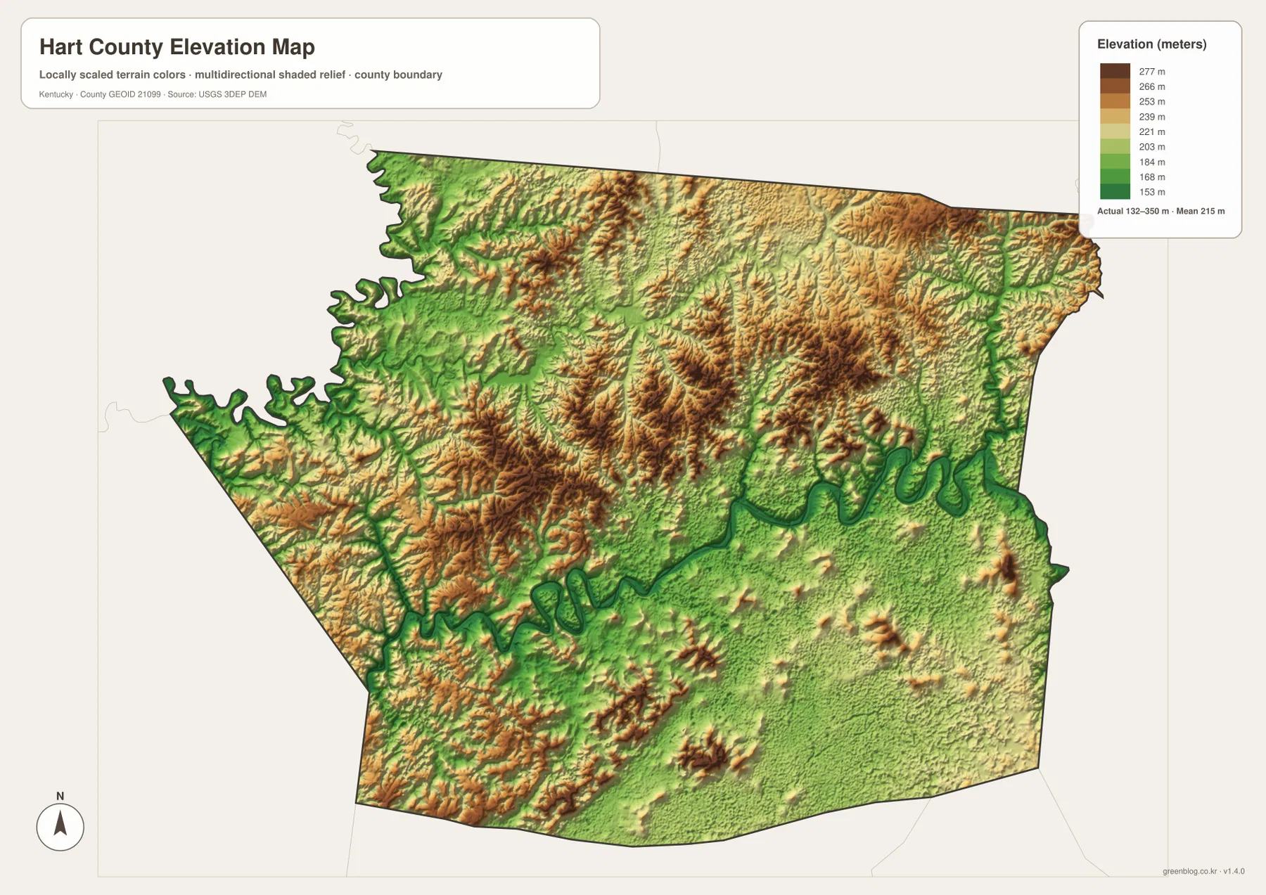
The elevation map reports an actual range of about 132 to 350 meters and a mean elevation of 215 meters. The lowest green band follows the Green River corridor and several adjoining stream valleys, making the river’s winding route just as recognizable on the elevation layer as it is on the water map. Lower ground also spreads through parts of the west, where tributaries cut into the county boundary and create a broad network of narrow valleys.
Higher ridges are concentrated across much of the north and north-central interior, with additional elevated ground in parts of the west. Brown and tan bands are broken by green stream valleys, so the terrain changes repeatedly over short distances rather than forming one continuous high plateau. The southeast looks different again: broad lower-to-middle elevation areas are interrupted by smaller isolated hills, producing a more open pattern than the tightly dissected northern half.
This terrain helps explain the road network. I-65 can maintain a relatively continuous north-south route through the county, while many smaller roads bend along valleys or around ridges once they leave the central corridor. The elevation map is intended for county-scale comparison, not engineering or survey work. Exact property elevations, drainage design, and construction decisions require original USGS data or professional survey information.
Cave Country adds context to the roads, river, and settlement pattern
Hart County is part of Kentucky’s Cave Country, and that regional identity adds useful context to the maps. The Advisory Council on Historic Preservation describes the county as having three incorporated cities—Munfordville, Horse Cave, and Bonnieville—and notes the partial presence of Mammoth Cave National Park. That combination of small cities, a major interstate, the Green River, and karst country helps distinguish Hart County from nearby counties that may have similar rolling terrain but a different travel pattern.
Horse Cave/Hart County Tourism highlights caves, outdoor recreation, history, and rural attractions across the county. Those visitor resources are not substitutes for the geographic layers here, but they help explain why Horse Cave and the I-65 corridor matter beyond ordinary road travel. A visitor can use the county map to establish where Horse Cave and Munfordville sit, then consult official attraction or park pages for exact addresses, opening hours, trail access, and cave-tour details.
Munfordville provides another useful orientation point because the town and the Green River are closely linked. North and west of the river, the map shows a denser pattern of short valleys and ridges; farther south around Horse Cave, the main roads are easier to follow at county scale. Looking at the road, water, and elevation layers together turns those differences into a coherent geographic picture rather than a collection of isolated labels.
Use the detailed map for roads and the terrain layers for Green River country
Start with the county map when the question is about Horse Cave, Munfordville, Bonnieville, I-65, U.S. 31W, or the surrounding state routes. The city-connections map is better when only the three principal settlement locations and their relative distances matter. Its simplified design works well for a quick orientation before moving to the more detailed road network.
The water and terrain map is the stronger choice for the Green River and tributaries such as Bacon Creek, Round Bottom Creek, Little Dog Creek, and Lynn Camp Creek. Pair it with the elevation map to see which waterways occupy lower corridors and where the surrounding ridges rise. This comparison is particularly useful in Hart County because the river bends and dissected northern terrain are central to the county’s geography.
The WebP images on the page are optimized for quick viewing, while the downloadable JPG originals are better for printing, enlarging small road labels, or comparing details side by side. Saving the ZIP makes it easy to open the county map beside the water map or elevation map without repeatedly switching web images.
Frequently Asked Questions
Which Hart County cities are easiest to use for orientation?
Horse Cave, Munfordville, and Bonnieville form the clearest north-south reference chain. On the city map, Horse Cave is the hub, Munfordville is about 7 miles away, and Bonnieville is about 14 miles away by straight-line distance. I-65 makes the same general corridor easy to recognize on the detailed county map.
Which map is best for following the Green River and Hart County creeks?
The water and terrain map is the most useful choice. It shows the Green River’s major bends along with named tributaries such as Bacon Creek, Round Bottom Creek, Little Dog Creek, and Lynn Camp Creek. The elevation map adds useful context by showing that many of those waterways occupy lower valleys between surrounding ridges.
Does the elevation map show survey-grade heights?
No. It summarizes county-wide terrain, with an actual range of about 132 to 350 meters and a mean of 215 meters. The map is appropriate for comparing river valleys and ridges, but exact property, building, or engineering elevations should come from USGS source data or a qualified survey.
Map File Information
Download the Hart County road and boundary map, city-connections map, water and terrain map, and elevation map as high-resolution JPG originals.
- Included Files: county map, city map, water and terrain map, elevation map
Related Maps
Sources and References
County history and local context are available from the Advisory Council on Historic Preservation’s Hart County profile and Horse Cave/Hart County Tourism. Cave Country and park information can be checked through the National Park Service’s Mammoth Cave National Park. Boundary and road source material is available from U.S. Census Bureau TIGER/Line, water data from USGS National Hydrography, and elevation information from the USGS 3D Elevation Program.
Green Map creates custom-edited map images using open geographic data sources such as geoBoundaries, Natural Earth, OpenStreetMap, and government open data. These maps are edited visual materials, not raw data files, and are provided for education, documents, presentations, and graphic reference.