Clark County occupies a compact part of east-central Kentucky with Winchester as its clear urban center. On the general map, Winchester sits slightly north of the county’s midpoint, Interstate 64 runs east–west just above the city, and U.S. 60 continues toward the eastern side. The southern edge feels very different: the Kentucky River follows a deeply curved valley along the county boundary, while a network of smaller creeks cuts through the uplands between Winchester and the river. High-resolution map files are available for download in the section below.
This page brings together four views of the county so roads, settlement, waterways, and relief can be compared without crowding every feature onto one image. The original high-resolution JPG versions can also be downloaded as a ZIP when you need more detail for printing or close inspection. These are county-reference maps rather than parcel, flood, survey, or turn-by-turn navigation products, so legal boundaries and time-sensitive conditions should always be checked in the appropriate current source.
Table of Contents
Winchester and I-64 form the county’s easiest orientation line
Winchester is the first feature to locate on the general map. The developed area spreads across the north-central interior, while I-64 crosses just to the north and provides the strongest east–west transportation line. U.S. 60 leaves Winchester toward the east, and state routes such as KY 15, KY 89, KY 974, KY 627, and KY 418 branch toward different parts of the county. Together they make Winchester look less like one isolated point and more like the hub from which the rural road network fans outward.
The map also includes useful local reference points. Clark Regional Hospital appears near Winchester, Silver Creek is marked as a historical place in the northwest, Ford lies close to the southwestern edge, and Vienna is labeled near the south. These names are not all communities of the same size, but they help a reader judge how far the county extends beyond Winchester and how quickly the closely spaced roads around the city gives way to more widely spaced rural routes.
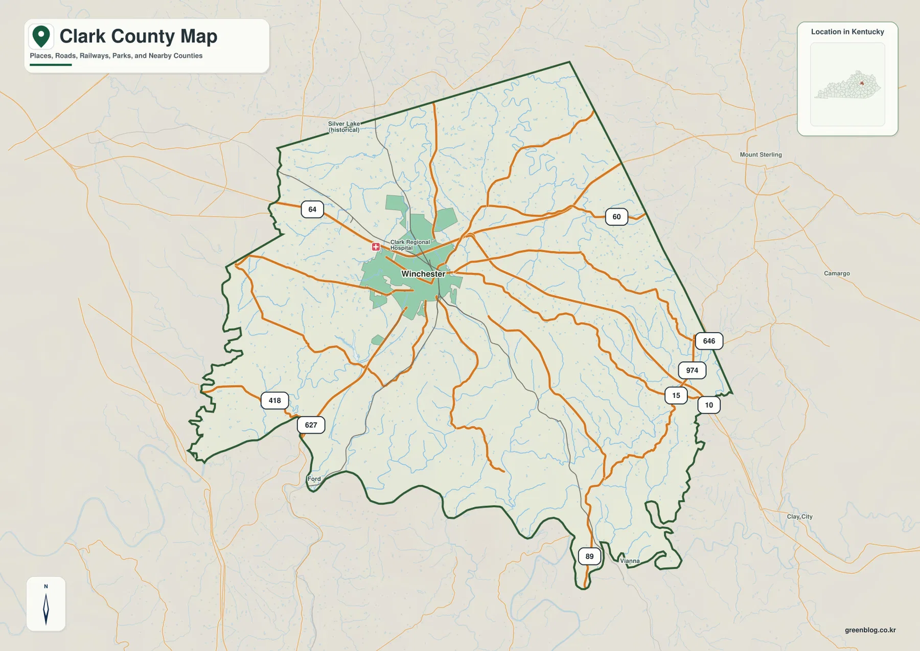
Roads heading south cross a noticeably different landscape from the interstate corridor. KY 627 runs southwest from Winchester toward the Kentucky River, and KY 89 extends toward the narrow southern end of the county. In the southeast, KY 15, KY 10, and KY 974 provide useful reference points near the county edge. Many local roads bend rather than following a simple grid because they must pass between short ridges and creek valleys, a pattern that becomes even clearer on the water and elevation maps.
Clark County’s official profile emphasizes its location on I-64 and its proximity to I-75, which helps explain why the interstate is such an important geographic reference for the county. The map visually supports that description: major local roads converge near Winchester, meet or approach the interstate, and then spread back into the surrounding countryside. For a first look at Clark County, finding Winchester and I-64 before tracing a specific state road is the fastest way to build a reliable sense of direction.
Why the city map highlights Winchester alone
The city-distribution map is unusually simple because it identifies only one ranked major city inside Clark County: Winchester. Its index lists Winchester first with a displayed population of 19,213. There are no connector lines between several ranked cities, as there are on some county maps, so the main purpose here is to show where the county’s dominant urban center sits within the boundary rather than to compare multiple city-to-city distances.
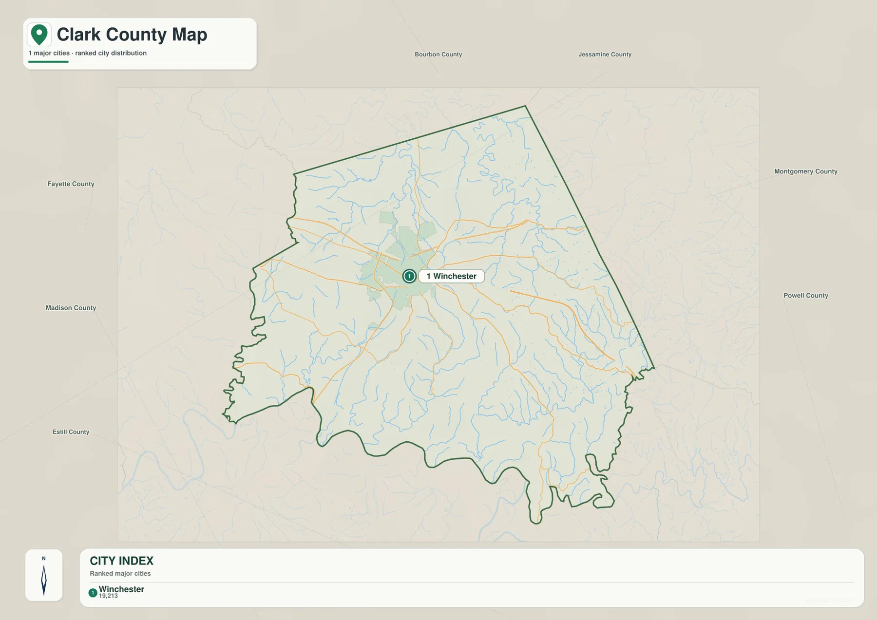
That simplicity is useful when the road network would otherwise distract from the location of Winchester and the surrounding rural area. Winchester lies well inside the county rather than directly on an outer boundary, and the map shows substantial rural territory extending south toward the Kentucky River as well as east and west toward neighboring counties. Once Winchester is fixed as the central reference point, the general road map can be used to add I-64, U.S. 60, and the state routes without losing the larger geographic picture.
The surrounding labels also place Clark County within a wider east-central Kentucky setting. Bourbon, Montgomery, Powell, Estill, Madison, and Fayette counties appear around the map area, although the city view is not intended to catalogue every nearby community or calculate driving distances. It works best as an orientation graphic: Winchester provides the anchor, and the county boundary shows how much of Clark County consists of countryside, creek valleys, and rolling upland beyond the city itself.
Winchester also functions as the county’s main civic and visitor center. The Winchester-Clark County Tourism Commission highlights the historic downtown, local cultural attractions, and outdoor destinations associated with the Kentucky River landscape. Those visitor details are not encoded directly in this city map, but they help explain why a single place dominates the settlement view. Anyone planning an actual visit should still check current opening hours, road conditions, and destination-specific directions before traveling.
Kentucky River valleys and the Howard Creek network shape the south
The water map becomes easiest to understand when the Kentucky River is used as the main reference. It curves along much of the southern side of Clark County, occupying a deeply incised valley that contrasts with the higher interior. Smaller creeks descend through branching valleys toward this larger river system, and the shaded relief beneath the blue water lines shows how closely drainage and terrain are connected in the southern half of the county.
Lower Howard Creek runs toward the Kentucky River in the southwest, while Four Mile Creek crosses the south-central interior. Farther east, Upper Howard Creek and Long Branch occupy another set of narrow valleys, and the Red River is labeled just beyond the county near the southeastern side. These streams make the southern edge look much more dissected than a simple county-outline map would suggest. Roads in the same area often bend around ridges or follow the easier grades available beside creek valleys.
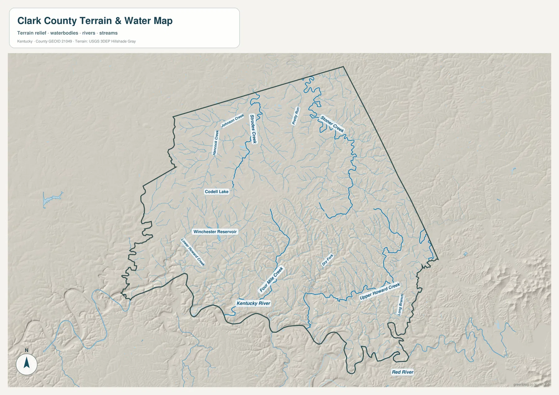
North of Winchester, the drainage network changes scale. Johnson Creek, Strouds Creek, Pretty Run, and Silver Creek are among the named streams in the northern half, while Hancock Creek appears farther west. Codell Lake and Winchester Reservoir add two inland water bodies close enough to the urban area to serve as useful local reference points. They are much smaller than the Kentucky River, but they help show that Clark County’s water geography includes both major river valleys and a dense network of smaller creeks and impoundments.
The Lower Howard’s Creek Nature and Heritage Preserve, promoted by Winchester-Clark County tourism, provides a real-world example of the steep creek-and-river landscape shown on the map. Even so, this water view should not be treated as a flood map, current water-level report, property-boundary document, or boating chart. Its value is geographic: it shows which named streams lie near Winchester, which drain toward the Kentucky River, and where the river valley creates the county’s strongest low-elevation corridor.
A 168–341 m range separates high uplands from the river corridor
The elevation map shows an actual mapped range of roughly 168 to 341 meters, with a mean near 275 meters. The lowest colors follow the Kentucky River and several southern tributary valleys, while broad areas of tan and brown cover the northern and eastern uplands. The average alone therefore does not describe the county very well. Clark County contains a substantial contrast between low river corridors and elevated rolling ground that remains high across much of the interior.
Short ridges and narrow valleys are especially dense across the north and northeast. Even the country around Winchester and I-64 is not completely flat; streams cut into the upland surface and create repeated changes in local relief. Toward the southeast, the terrain drops sharply into valleys associated with Upper Howard Creek and Long Branch. This change in terrain helps explain why road alignments can curve frequently once they leave the more open routes around Winchester.
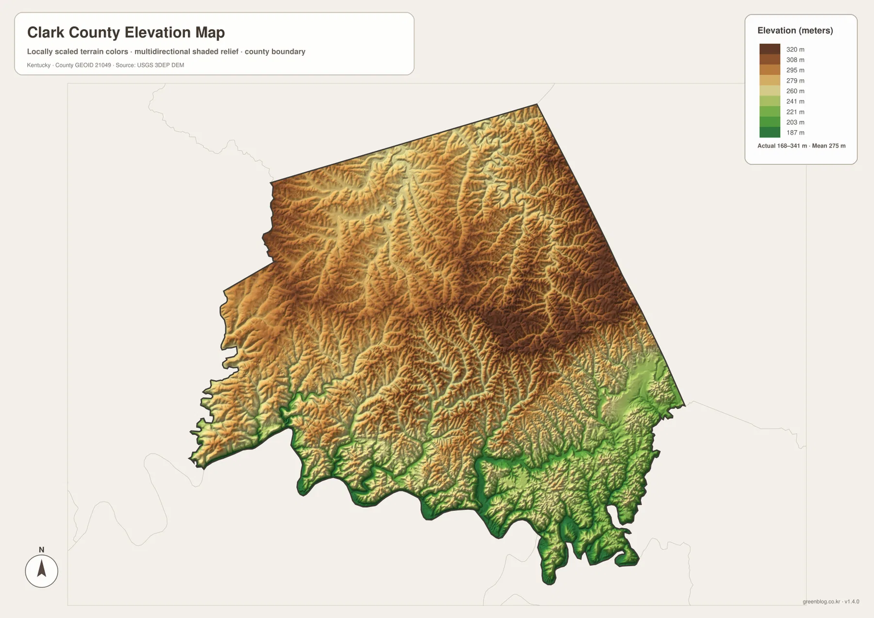
The western and southwestern edge shows the most abrupt transition into the Kentucky River corridor. Green lowlands occupy the valley floor and narrow tributary routes, while higher ridges rise quickly beside them. Comparing this image with the water map makes Lower Howard Creek and Four Mile Creek easier to interpret because the streams align with the lower channels cut between higher ground. Two places that look close in a straight line may therefore require a longer road route when ridges and incised valleys intervene.
These elevation colors group the county into broad height ranges for comparison and are not survey-grade elevation measurements. They should not be used to determine a building-site elevation, exact slope, drainage design, or engineering requirement. More precise work calls for detailed source data such as the USGS 3D Elevation Program or a professional survey. For a county-wide overview, however, the 168–341 meter span and the low Kentucky River corridor clearly explain the county’s broad topographic contrast.
Choosing the clearest map for roads, water, or terrain
Use the general county map when Winchester, major roads, and the boundary need to be seen together. It is the best single view for following I-64, U.S. 60, KY 15, KY 89, KY 627, and the smaller routes toward Ford, Vienna, or the county edges. The city map is better for a presentation that only needs the location of Winchester and the surrounding rural area. Because Winchester is the sole ranked major city, that version removes road clutter and makes the county’s urban-versus-rural balance immediately visible.
Choose the water map when you need the Kentucky River, the Howard Creek system, Four Mile Creek, Silver Creek, Winchester Reservoir, or Codell Lake. Choose the elevation map when the main question is how low the river valleys sit compared with the higher ground to the north and east. Looking at both makes it easier to see why many streams follow narrow valleys and why several roads curve through the southern half of the county.
The high-resolution JPG files in the ZIP are preferable when labels need to remain readable in print or on a larger display. Each map keeps one purpose clear instead of stacking all information into a single crowded graphic. Current road closures, property ownership, flood zones, stream conditions, and legal boundaries are outside the scope of these reference maps and should be checked through the relevant up-to-date official service.
Frequently Asked Questions
Which map is best for locating Winchester and I-64?
The general county map is the best choice because it shows Winchester, I-64, U.S. 60, and the main Kentucky state routes together. If you only need to explain where the county’s primary city sits inside the boundary, the city map is cleaner because Winchester is the only ranked major city shown there.
Can the Kentucky River and Howard Creek system be seen on one map?
Yes. The water map shows the Kentucky River along the southern side as well as Lower Howard Creek, Upper Howard Creek, Four Mile Creek, and several northern tributaries. Winchester Reservoir and Codell Lake are included too, so the major river corridor and smaller inland water features can be compared in the same view.
What stands out most on the 168–341 m elevation map?
The clearest contrast is the low Kentucky River and tributary valleys in the south against the higher rolling uplands across much of the north and east. The mean is about 275 meters, but the map is generalized for county-scale comparison and should not be used as a precise elevation source for an individual property.
Map File Information
The original Clark County maps used on this page are bundled as high-resolution JPG files suitable for printing and close inspection. Each original is 3638 × 2572 px, providing more room to examine place labels, roads, waterways, and relief than the screen-sized WebP versions.
- Included Files: county map, city map, water map, elevation map
- File Type: JPG
Related Maps
Sources and references
County government and local orientation can be checked on the official Clark County website. Winchester and Clark County visitor, heritage, and outdoor information is available from the Winchester-Clark County Tourism Commission and the Kentucky Tourism Winchester guide. Boundary data can be referenced through U.S. Census Bureau TIGER/Line, hydrography through USGS National Hydrography, and elevation through the USGS 3D Elevation Program.
Green Map creates custom-edited map images using open geographic data sources such as geoBoundaries, Natural Earth, OpenStreetMap, and government open data. These maps are edited visual materials, not raw data files, and are provided for education, documents, presentations, and graphic reference.