Kearny County lies in southwestern Kansas, where Lakin and Deerfield sit along the same broad Arkansas River transportation corridor. Lakin is the county seat and largest city, while Deerfield is the second major community to the east. U.S. 50 and U.S. 400 connect both towns, and K-25 runs south from the Lakin area. High-resolution JPG versions of the maps shown on this page can be downloaded together from the ZIP box below. High-resolution map files are available for download in the section below.
The Arkansas River is the county’s strongest natural reference. Sand Creek and numerous smaller tributaries descend from the higher northern plains, while named irrigation ditches cluster around the river near Lakin and Deerfield. Lake McKinney appears farther east, and Bear Creek forms a separate valley in the southern county. Elevation ranges from about 890 to 1,049 meters with a mean near 965 meters, showing a strong decline from the western and northwestern High Plains toward the river and eastern lowlands.
Kansas Historical Society records show that Kearny County was created in 1873 and organized in 1888, with Lakin serving as the county seat. The Santa Fe Trail followed the Arkansas River through the county for decades, and an intact trail segment known as Charlie’s Ruts survives west of Deerfield. Modern U.S. 50 and U.S. 400 use the same broad east-west corridor, giving the county an unusually clear link between physical geography and transportation history.
Table of Contents
Lakin and Deerfield share the U.S. 50–400 corridor
Lakin sits in the southern-central county and provides the best road reference. U.S. 50 and U.S. 400 approach from the west, pass through the Lakin corridor, and continue east toward Deerfield and Finney County. K-25 heads south from Lakin, adding the principal north-south route for the southern part of Kearny County.
Deerfield lies east of Lakin on the same highway and river corridor. Smaller labels such as Sutton and Hartland help identify the western and southwestern rural landscape, where incorporated towns are scarce. Once Lakin, Deerfield, the Arkansas River, and U.S. 50/400 are located, the rest of the county road network becomes much easier to understand.
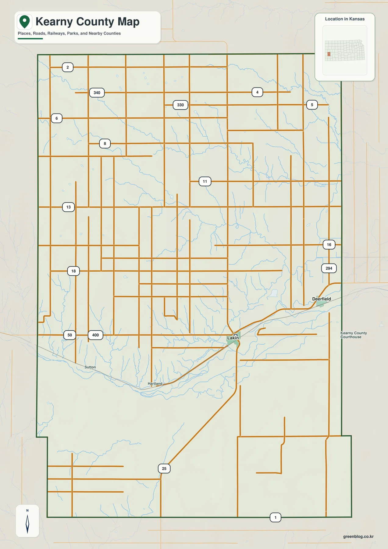
The northern half contains long straight rural roads and very little urban development. Toward the south, roads meet creek valleys, the river corridor, and irrigation features that interrupt the otherwise regular agricultural grid. This map is intended for county-scale orientation rather than live navigation, so current construction, unpaved-road conditions, high winds, and winter weather should be checked separately.
Two towns hold nearly all of the visible urban concentration
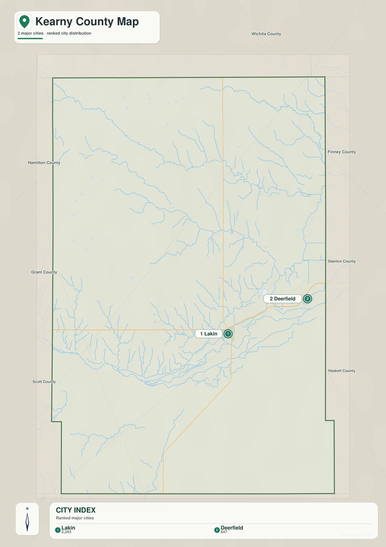
The city distribution map ranks Lakin first and Deerfield second. The displayed source values are 2,243 for Lakin and 647 for Deerfield, figures that may differ from later estimates. The stable geographic pattern is more important: these two communities contain nearly all of the county’s visible urban concentration.
Lakin combines the county-seat role with the U.S. 50/400 and K-25 junction, while Deerfield provides the main eastern town reference. The land between them remains agricultural rather than forming a continuous urban strip, even though both towns occupy the same transportation and river corridor.
Historical Society collections describe both towns as early centers along the railroad and Arkansas River corridor. Lakin developed as the county seat, while Deerfield grew from homesteading, agriculture, commerce, and transportation. The modern two-town map preserves that simple settlement pattern.
The Arkansas River lowland is lined with creeks and irrigation ditches
The Arkansas River crosses the southern county from west to east and forms the most continuous low corridor on the water map. It passes the Lakin–Deerfield area and receives many small tributaries descending from higher ground. The valley is also the main location for named irrigation infrastructure.
Sand Creek is one of the clearest tributaries approaching the river from the northwest of Lakin. Farther east, Lake McKinney provides another water reference. Labels such as Great Eastern Ditch, Southside Ditch, and Number 31 Ditch cluster around the river, showing how strongly agricultural water management is tied to the valley.
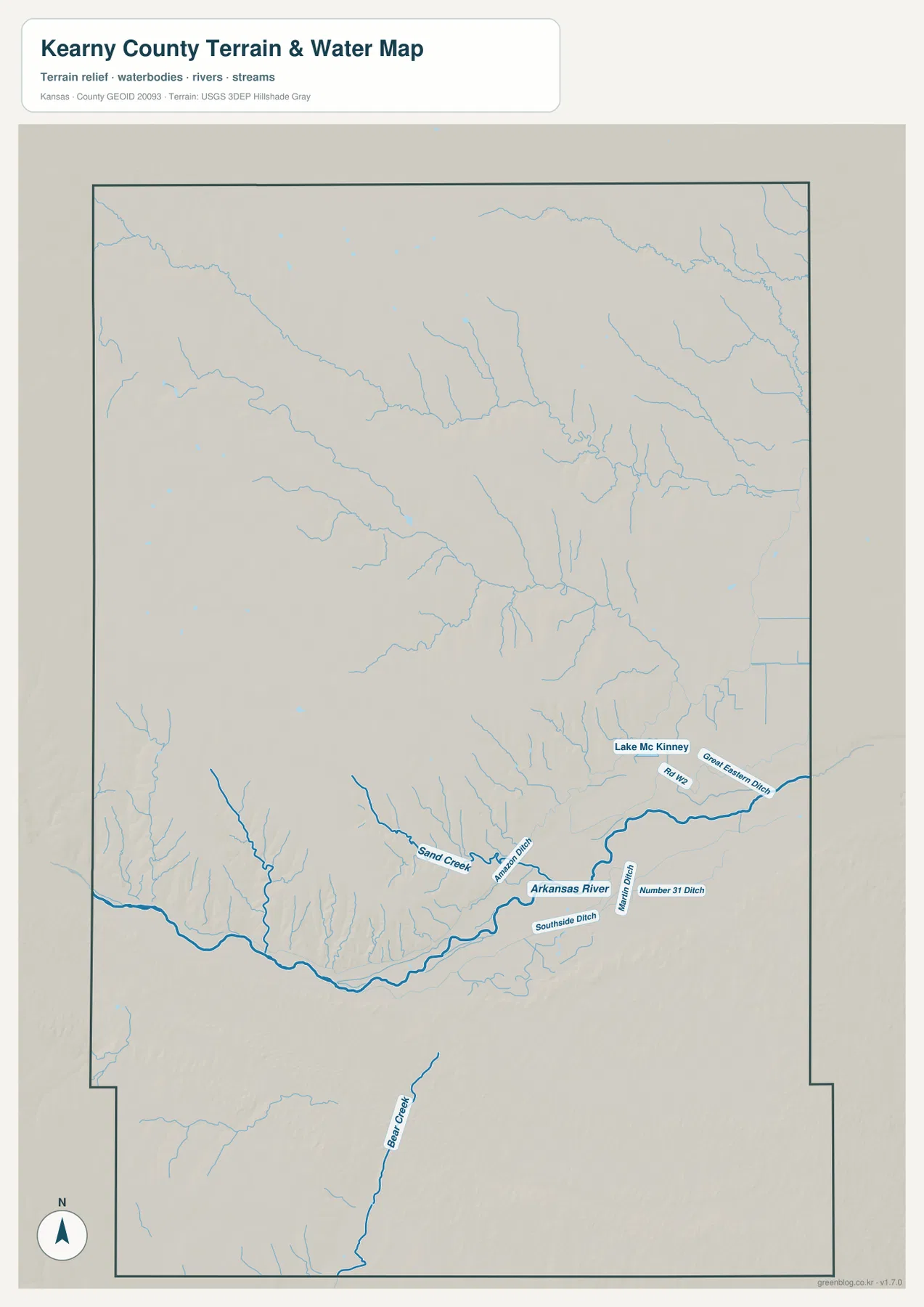
Bear Creek creates a separate valley in the southern part of the county. Many smaller High Plains channels may carry very different amounts of water depending on season and precipitation. The map therefore provides geographic context rather than live streamflow, flood, or irrigation-operation information; current conditions should be checked through USGS or responsible local agencies.
The land falls from 1,049-meter western uplands toward the river
Kearny County ranges from approximately 890 to 1,049 meters in elevation and averages near 965 meters. Brown and orange colors dominate the west and northwest, while yellow-green and green become more common toward the east. The Arkansas River creates the broadest low band across the southern county.
Many tributary valleys descend from the higher northern plains and become more deeply cut as they approach the river. Around Lakin and Deerfield, a broad river lowland and lower terraces replace the higher western surface. Bear Creek also forms a noticeable southern depression, so the county is not simply a flat plateau despite its High Plains setting.
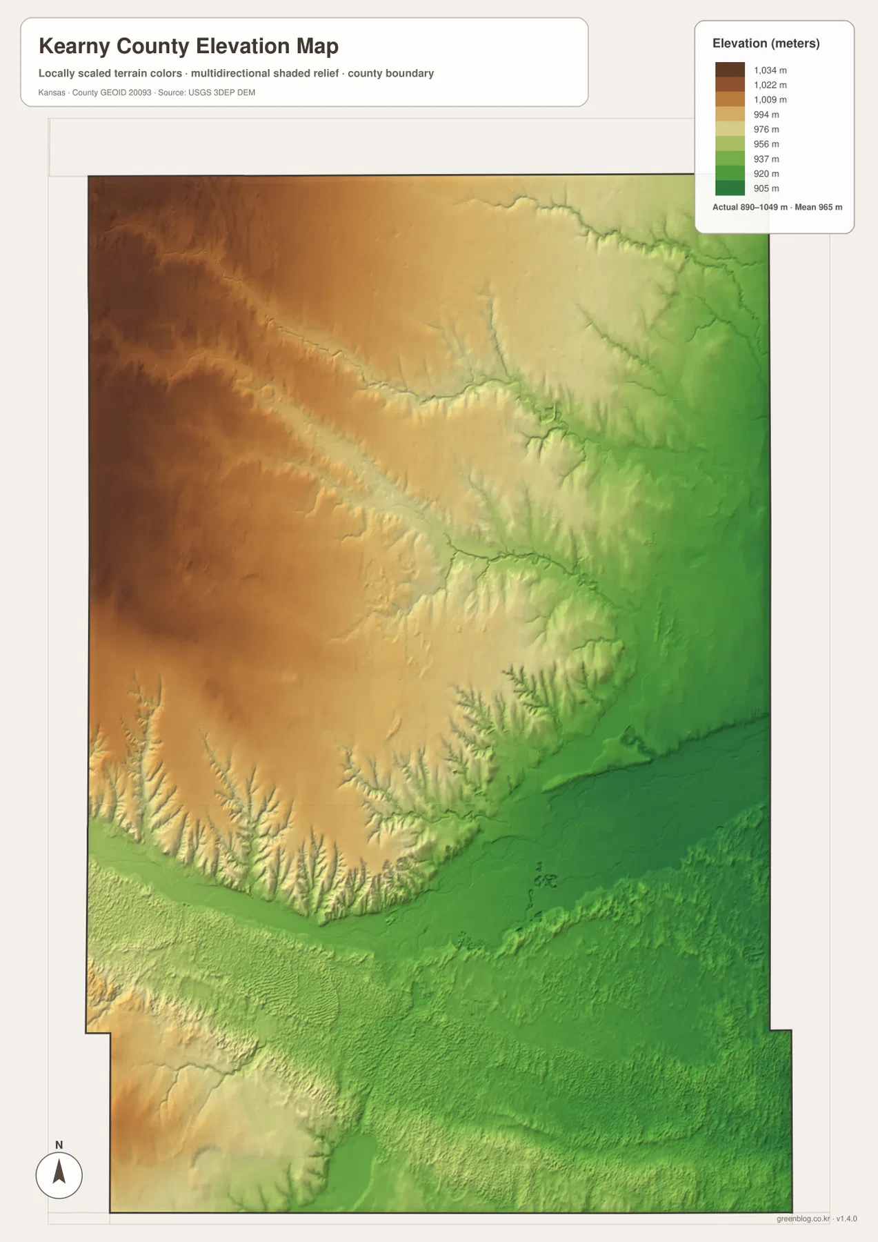
This elevation surface is intended for county-scale comparison rather than survey-grade measurement. It should not be used to establish exact parcel elevations, design drainage, or replace engineering and legal survey data. Its main value is showing the broad west-to-east decline and the sharply lower Arkansas River corridor.
Why the Santa Fe Trail followed the Arkansas River
Kansas Historical Society accounts of early Kearny County describe Santa Fe Trail traffic following the Arkansas River through the area from the nineteenth century until rail transportation replaced the wagon route. The broad river valley offered a practical corridor through the higher High Plains and provided access to water along the journey.
West of Deerfield, a preserved trail segment known as Charlie’s Ruts still contains visible wagon swales. The Kansas Historical Society lists the site in the National Register for its transportation significance. Its location near today’s U.S. 50 makes the relationship between the historic trail and the modern highway corridor especially easy to understand.
Lakin and Deerfield later developed along the same river-and-rail setting. Historical records from the county include freighting stories, Deerfield settlement accounts, and early bridge history. The modern map therefore represents more than present-day roads; it shows a corridor that has guided movement and settlement for generations.
Irrigation adds another layer to the river geography
The water map includes several named ditches in addition to natural streams. These channels were built to move water through agricultural lands near the Arkansas River, and their concentration around Lakin and Deerfield illustrates the close relationship between farming and the valley’s water resources.
Great Eastern Ditch, Southside Ditch, and Number 31 Ditch follow or branch from the river corridor, while Lake McKinney provides another eastern reference. Their presence on the map helps explain why the southern county contains a more intricate water network than the broad uplands farther north.
Western and northern Kearny County sit higher and generally show fewer large water features. Comparing the elevation and water maps reveals the basic pattern: water and settlement concentrate in lower valleys, while the High Plains uplands remain more open and sparsely settled.
Using the maps for printing, study, and county orientation
For road orientation, begin with Lakin and follow U.S. 50/U.S. 400 east toward Deerfield, then use K-25 for the southern route. For physical geography, trace the Arkansas River and compare Sand Creek, Bear Creek, Lake McKinney, and the irrigation ditches. The elevation map then explains why the main settlement and transportation corridor occupies lower ground.
The high-resolution JPG files in the ZIP are better suited than the reduced web previews for printing, classroom projects, Santa Fe Trail history, and close inspection of road and water labels. Current road conditions, live stream information, irrigation operations, parcel boundaries, and exact elevations should always be checked against the latest authoritative sources when those details matter.
Frequently Asked Questions
Where is Lakin on the Kearny County map?
Lakin sits in the southern-central county and serves as the county seat and largest city. U.S. 50 and U.S. 400 run east-west through the area, while K-25 heads south, making Lakin the easiest first reference for county orientation.
Why are so many irrigation ditches shown near the Arkansas River?
The Arkansas River valley is the county’s main lowland and agricultural water corridor. Named ditches such as Great Eastern Ditch, Southside Ditch, and Number 31 Ditch show how water has been distributed through farmland near Lakin and Deerfield.
Can the 890–1,049 meter elevation map be used for surveying?
No. The elevation map is a county-scale visual reference for comparing the High Plains uplands with lower river and creek valleys. Exact parcel elevations, construction design, drainage engineering, and legal surveys require purpose-built data and professional methods.
Map File Information
Download the high-resolution JPG files corresponding to the Kearny County general, city distribution, terrain-and-water, and elevation maps in one ZIP archive.
- Included Files: Use only the versions confirmed in the article and supplied images
- File Type: Use the confirmed download contents
- Intended Use: Printing, education, presentations, and map-based projects
Related Maps
Sources and references
- Kearny County, Kansas official website — county government and Lakin administrative information
- Kansas Historical Society — Kearny County History Collection — county organization, Lakin, Deerfield, and local history
- Kansas Historical Society — Sketches of Early Days in Kearny County — Santa Fe Trail, settlement, and Arkansas River context
- Kansas Historical Society — Kearny County National Register listings — Charlie’s Ruts and Deerfield historic resources
- USGS National Hydrography — hydrography and stream-network data information
- USGS 3D Elevation Program — elevation data information
Green Map creates custom-edited map images using open geographic data sources such as geoBoundaries, Natural Earth, OpenStreetMap, and government open data. These maps are edited visual materials, not raw data files, and are provided for education, documents, presentations, and graphic reference.