Fayette County lies in eastern Indiana, where Connersville forms the clearest settlement and road center and the Whitewater River occupies a low north–south valley through the county. You can download the high-resolution JPG versions of every map on this page in one ZIP file, making the set useful for printing, class work, trip planning, and side-by-side geographic comparison. The Fayette County Indiana Map collection includes a county map for boundaries, places, and roads, a ranked city map, a terrain-and-water map, and an elevation map.
The maps become more useful when they are read together rather than as four unrelated images. The general map establishes the county outline and shows Connersville, Glenwood, Everton, Bentonville, and numbered routes. The city map emphasizes how strongly the county’s largest mapped urban center is concentrated in Connersville. The water map traces the Whitewater River and a network of tributaries, while the elevation map explains why the river corridor appears as a lower green band between higher ground to the west and east. That shared geographic story gives the page more value than a simple list of map types.
Table of Contents
Connersville anchors the road and boundary map
The general county map makes Connersville the easiest place to use as an orientation point. Its developed area sits near the central part of the county, close to the step where the northern extension meets the larger southern section of the county outline. The Fayette County Courthouse and an emergency medical facility are labeled within the Connersville area, reinforcing its role as the county seat and service center. A small locator map in the upper-right corner places Fayette County in the eastern part of Indiana, which is helpful for readers who know the state but are not familiar with the county’s exact position.
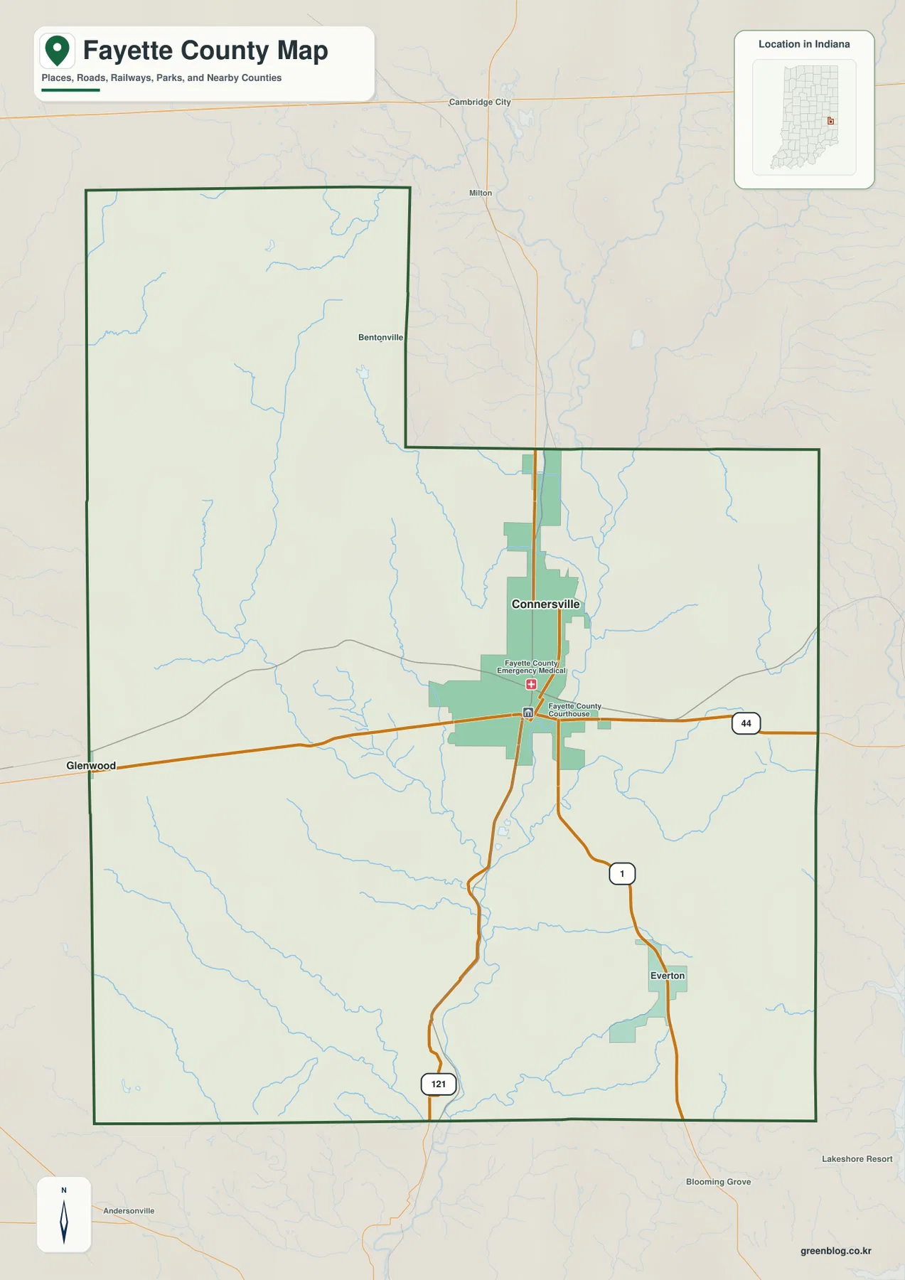
Route 44 crosses the county from west to east and passes through Connersville. Route 1 leaves the city toward the southeast and continues in the direction of Everton, while the road marked 121 runs south from the Connersville area. Glenwood is shown near the western boundary along the Route 44 corridor, Everton appears in the southeast, and Bentonville is labeled in the northern extension. These points create a simple mental framework: Connersville is the main center, Route 44 provides the strongest east–west reference, and the southbound routes help organize the lower half of the county.
This map is best treated as a county overview, not as a parcel or legal-boundary product. Its strength is the combination of places, roads, streams, and the bold county outline on one page. If you are preparing a classroom map, checking the general direction from Connersville to Glenwood or Everton, or trying to understand why the county shape has a northern projection, the general map gives enough context without overwhelming the reader with specialized GIS layers. It also provides the reference frame needed to interpret the water and elevation maps later on the page.
The ranked city map shows a single dominant urban center
The supplied city map is intentionally selective. Instead of labeling every small community at equal weight, it ranks the major city represented in the dataset. Connersville is the only ranked major city and is marked as number 1; the CITY INDEX at the bottom displays a value of 13,109. That figure should be read as the value used by this map’s city index rather than assumed to be the newest population estimate. The important geographic point is the concentration: the county’s main mapped urban center is clearly Connersville rather than a chain of similarly sized cities spread across the county.
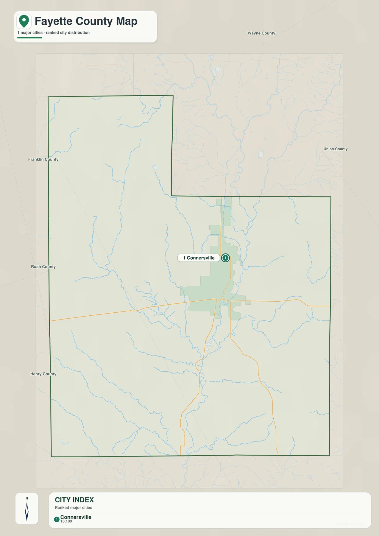
Neighboring county labels help establish regional context. Wayne County appears to the north, Union County to the east, and Franklin, Rush, and Henry counties are shown on the western and southwestern sides of the surrounding area. Because the Fayette County outline has a noticeable northern extension, those labels are useful when a reader is trying to understand which side of the county is closest to a particular neighbor. The map also makes it easy to see that Connersville is not tucked against one outer corner; it sits in the main body of the county near the crossing of important road corridors and close to the river valley.
A ranked city map also has limits. A community that is absent from this particular index has not disappeared from the county; the map simply does not attempt to list every town, unincorporated place, or neighborhood. Glenwood, Everton, and Bentonville remain useful local references on the general map even though Connersville is the only city ranked on this view. For someone new to Fayette County, using the city map to identify the main center and then returning to the general map for smaller places is a clearer method than trying to force one image to answer every settlement question.
The Whitewater River collects tributaries from both sides of the county
The terrain-and-water map gives the Whitewater River the strongest visual emphasis. It runs through the central part of Fayette County and continues south, receiving streams from several directions. Williams Creek approaches from the west and northwest, Little Williams Creek enters from the west-central area, and Lock Creek descends from the north and bends toward the central river system. Farther south, Fall Creek joins from the west. Village Creek drains in from the east, while Simpson Creek and other smaller channels show how the eastern side of the county is cut by narrow stream valleys.
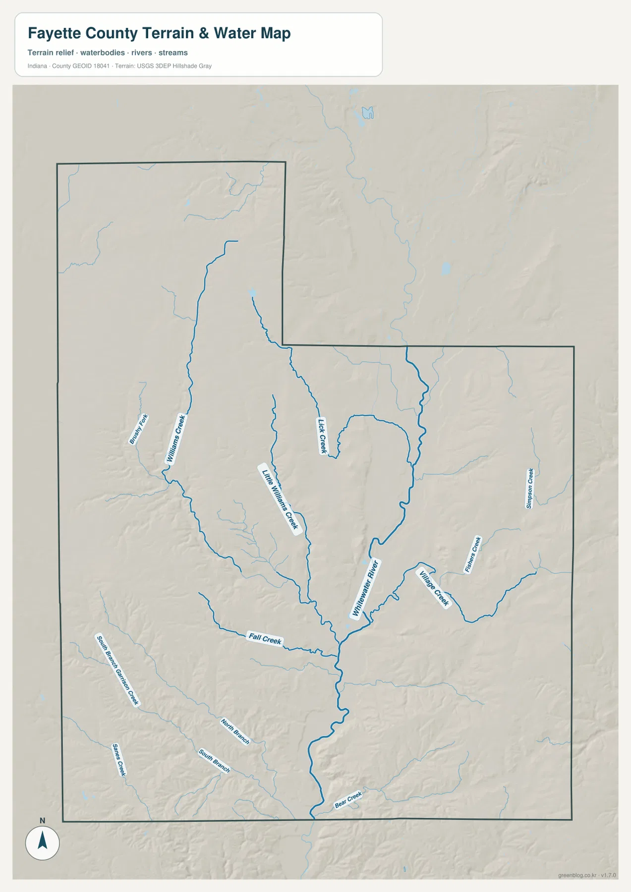
The pattern is useful because it explains more than the location of named streams. Several tributaries converge toward the central Whitewater River corridor, so the county’s drainage is visually organized around a larger valley rather than a set of disconnected waterways. Comparing this image with the general map shows why the Connersville area has both a strong road presence and a clear natural corridor nearby. The county’s official website also describes Fayette County in relation to the Whitewater River, which fits what is visible on the supplied maps without requiring assumptions about smaller features not shown here.
This is a reference map for waterways and surrounding terrain, not a flood-hazard, navigation, property, or regulatory map. A stream drawn on the map helps a reader understand the county’s drainage and landform setting, but it does not indicate a current floodplain boundary or tell whether a particular parcel is safe from flooding. Anyone making a legal, engineering, emergency-management, or insurance decision should use the current specialized products from the responsible agencies. For general geography, however, the map is excellent for seeing how Williams Creek, Fall Creek, Village Creek, and the other tributaries feed the main river valley.
Elevation falls into the Whitewater valley and rises toward the outer ridges
The elevation map provides a second way to understand the same river system. The supplied surface reports an actual county range of about 221 to 358 meters, with a mean elevation of about 295 meters. Greens represent lower areas, while yellows and browns represent progressively higher ground. The most obvious low area is the elongated green corridor running through the center and toward the south. Its position closely matches the Whitewater River valley shown on the terrain-and-water map, turning an abstract elevation legend into a recognizable feature on the ground.
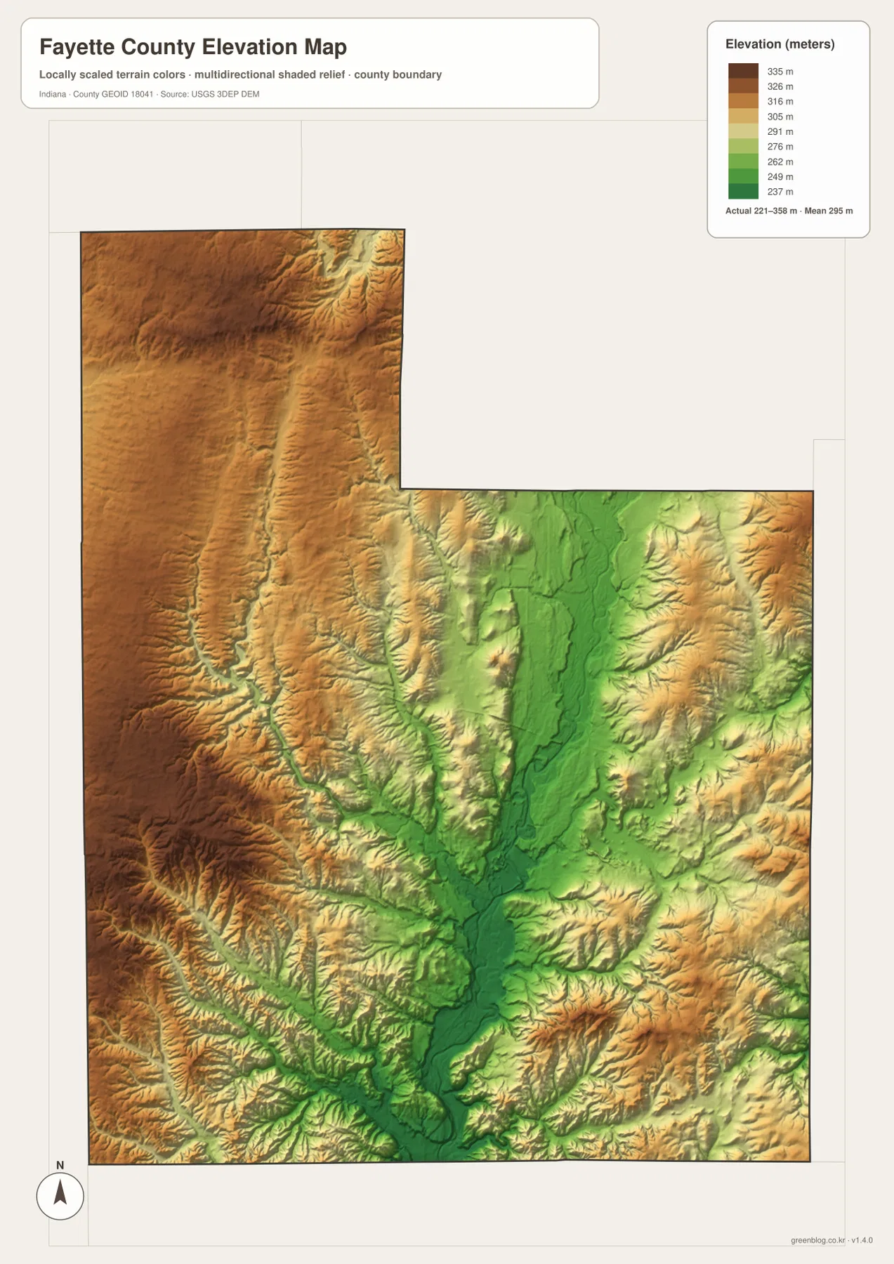
Higher terrain is especially noticeable across the western and northwestern parts of the county, where brown and orange colors occupy broad areas. On the eastern side, ridges also rise between tributary valleys, producing a more dissected pattern than a flat plain. In the southern half, the central low corridor remains green while the land rises quickly on both sides. This contrast helps explain why the drainage map contains so many short tributaries: small valleys descend from the higher surrounding terrain toward the Whitewater River system.
The elevation image should be used for broad comparison rather than site-level measurement. It is based on a generalized elevation surface derived from USGS 3DEP data and is not a substitute for a survey, engineering-grade topographic measurement, or an official construction dataset. The 221–358 meter range is very useful for answering questions such as “Which side of the county is generally higher?” or “Why does the central river corridor appear lower?” It should not be used to assign an exact elevation to a building, road shoulder, or property corner.
Roads and valleys line up around the county’s central corridor
When the maps are compared point by point, a consistent structure emerges. Connersville is the main city on the settlement maps, the Whitewater River occupies the central natural corridor, and the elevation map shows the same area as relatively low ground. Route 44 crosses this zone east to west, while Routes 1 and 121 extend southward from the Connersville area. The result is a county center where road access, settlement, and a major river valley are all visible in the same general part of the map. This does not prove why every road or neighborhood developed where it did, but it gives readers a practical geographic framework for further research.
The smaller communities provide useful checks on that framework. Glenwood lies near the western edge along Route 44, Everton sits to the southeast along Route 1, and Bentonville is located in the northern projection. Their positions show that Fayette County is not simply Connersville plus empty space; roads and waterways connect a wider rural landscape to the central city. At the same time, the city ranking makes clear that the county does not contain several similarly dominant urban centers. That combination of one main city, branching roads, and a river-valley system is one of the strongest visual themes shared by the supplied maps.
Choose the map according to the question you need to answer
For a quick county orientation, start with the general map because it combines the boundary, named communities, roads, and basic water features. If your question is about the county’s main urban center or its relationship to neighboring counties, the ranked city map is the simplest view. For river names, tributary connections, and the shape of the drainage network, use the terrain-and-water map. When the goal is to explain why a river corridor is low or where higher ground is concentrated, the elevation map provides the clearest evidence through its color scale and shaded relief.
The maps can also be paired for different projects. A student presentation can combine the county map with the elevation map to compare human and physical geography. A visitor planning an outdoor trip can use the water map to understand the Whitewater River system and then rely on current road or recreation information for actual travel decisions. Someone comparing eastern Indiana counties can use the city and boundary maps to see the position of Connersville relative to Wayne, Union, Franklin, Rush, and Henry counties. Selecting the view that matches the question prevents unnecessary detail from getting in the way.
High-resolution JPG files preserve the labels and map detail
The WebP images on this page are optimized for browser viewing. The ZIP package below contains the corresponding high-resolution JPG versions of all four supplied maps. Those larger files are better suited to printing, zooming in on stream names, placing a map in a report, or comparing terrain details on a large monitor. The general map retains the location inset and road labels, the water map keeps the named tributaries, and the elevation map includes its legend so the green-to-brown colors remain meaningful outside the webpage.
If you crop or edit a map for a document, try to preserve the north arrow, county outline, legend, and labels that make the image understandable. Enlarging a JPG can make existing detail easier to see, but it does not turn a reference map into a survey or legal record. For work that depends on exact boundaries, hydrography, or elevation measurements, check the current source data from the U.S. Census Bureau and USGS. For ordinary map reading, classroom use, regional comparison, and presentation graphics, the supplied files provide a clear and reusable overview of Fayette County.
Frequently Asked Questions
What is the county seat of Fayette County, Indiana?
Connersville is the county seat. The general map labels the Fayette County Courthouse within the Connersville area, and the ranked city map also emphasizes Connersville as the county’s principal mapped urban center.
Which map is best for finding the Whitewater River and its tributaries?
Use the terrain-and-water map for named waterways such as the Whitewater River, Williams Creek, Little Williams Creek, Lock Creek, Fall Creek, and Village Creek. If you also want to understand why those streams occupy particular valleys, compare it with the elevation map, where the central river corridor appears as lower green terrain.
Can the 221–358 meter elevation range be used for surveying?
No. The range is useful for county-wide geographic comparison, but the elevation map is a generalized surface rather than a survey-grade product. Use current official elevation data and a qualified survey when a project requires exact site elevations or engineering accuracy.
Map File Information
The ZIP package contains the original high-resolution JPG versions of the Fayette County county map, city map, terrain-and-water map, and elevation map shown on this page.
- Included Files: 4 high-resolution JPG maps
Related Maps
Sources and References
The following official sources are useful for checking county information, boundaries, hydrography, and elevation data. The maps on this page are designed as readable reference products; projects that require authoritative measurements should consult the latest data from the source agencies.
- Fayette County, Indiana official website – county government and local information
- U.S. Census Bureau TIGER/Line Shapefiles – county boundaries, roads, and place data
- USGS National Hydrography – rivers, streams, and hydrographic data
- USGS 3D Elevation Program – elevation and terrain data
Green Map creates custom-edited map images using open geographic data sources such as geoBoundaries, Natural Earth, OpenStreetMap, and government open data.
These maps are edited visual materials, not raw data files, and are provided for education, documents, presentations, and graphic reference.