Download four high-resolution JPG maps of Peoria County, Illinois, in one ZIP from this page, then use the article views to compare Peoria, Chillicothe, Elmwood, the Illinois River edge, Kickapoo Creek, and the county’s elevation. Peoria dominates the eastern urban area, with Peoria Heights, West Peoria, and Bartonville close around it. Chillicothe sits farther north along the river, while Elmwood marks a very different western interior setting.
The strongest physical contrast is between the low Illinois River corridor and the higher land immediately to its west. Peoria County’s official profile describes river bluffs transitioning into prairie-like terrain across the central and western county, and the supplied elevation map shows that transition clearly. Kickapoo Creek and West Fork Kickapoo Creek cut deep green valleys through the uplands before reaching the Peoria side. The actual elevation range is about 130 to 254 meters, with a mean near 198 meters.
Table of Contents
Peoria’s dense road network fades into the western small-town interior
The county map is busiest around Peoria. I‑474 curves around the southwestern side of the city, Route 150 approaches from the Brimfield direction, Route 91 runs south from Dunlap, and Route 40 serves the northern and central urban area. Along the Illinois River side, Route 29 continues north toward Chillicothe. Together these roads show why Peoria is both the largest city and the easiest starting point for locating the rest of the county.
Road spacing changes quickly to the west. Brimfield sits near Route 74, Elmwood is farther west around Route 78, and Princeville occupies the northern interior near Route 90. Hanna City and Glasford are scattered across the southwest. Compared with the Peoria urban edge, the western county has longer gaps between settlements and fewer major roads crossing the upland terrain.
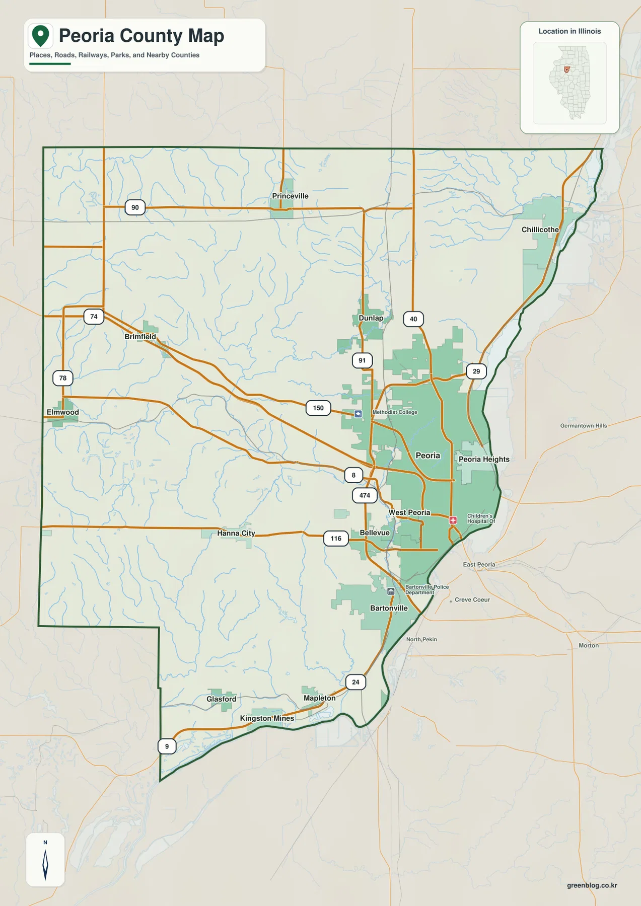
South of Peoria, Bartonville leads into the Mapleton and Kingston Mines side of the county along the Illinois River lowlands. The road pattern there is narrower and more linear than the dense Peoria grid because it follows the space between the river and higher inland terrain. This map is intended for geographic orientation rather than live navigation, so current traffic, closures, and driving times should still be checked with a dedicated road service.
Peoria overwhelms the city ranking while river and western towns remain separate
The ranked city map lists Peoria at 112,169, Chillicothe at 5,900, Bartonville at 5,841, Peoria Heights at 5,825, West Peoria at 4,238, and Elmwood at 2,327. Peoria is vastly larger than the other highlighted communities. Bartonville, Peoria Heights, and West Peoria sit close to the main city, so much of the ranked population is concentrated in the eastern urban area.
Chillicothe is different: it lies well north of the central urban cluster but still follows the Illinois River corridor. Elmwood represents the opposite side of the county, standing near the western edge far from the river cities. That distribution makes the city map especially useful for seeing Peoria County as an eastern urban concentration plus smaller river and inland communities rather than one evenly distributed settlement pattern.
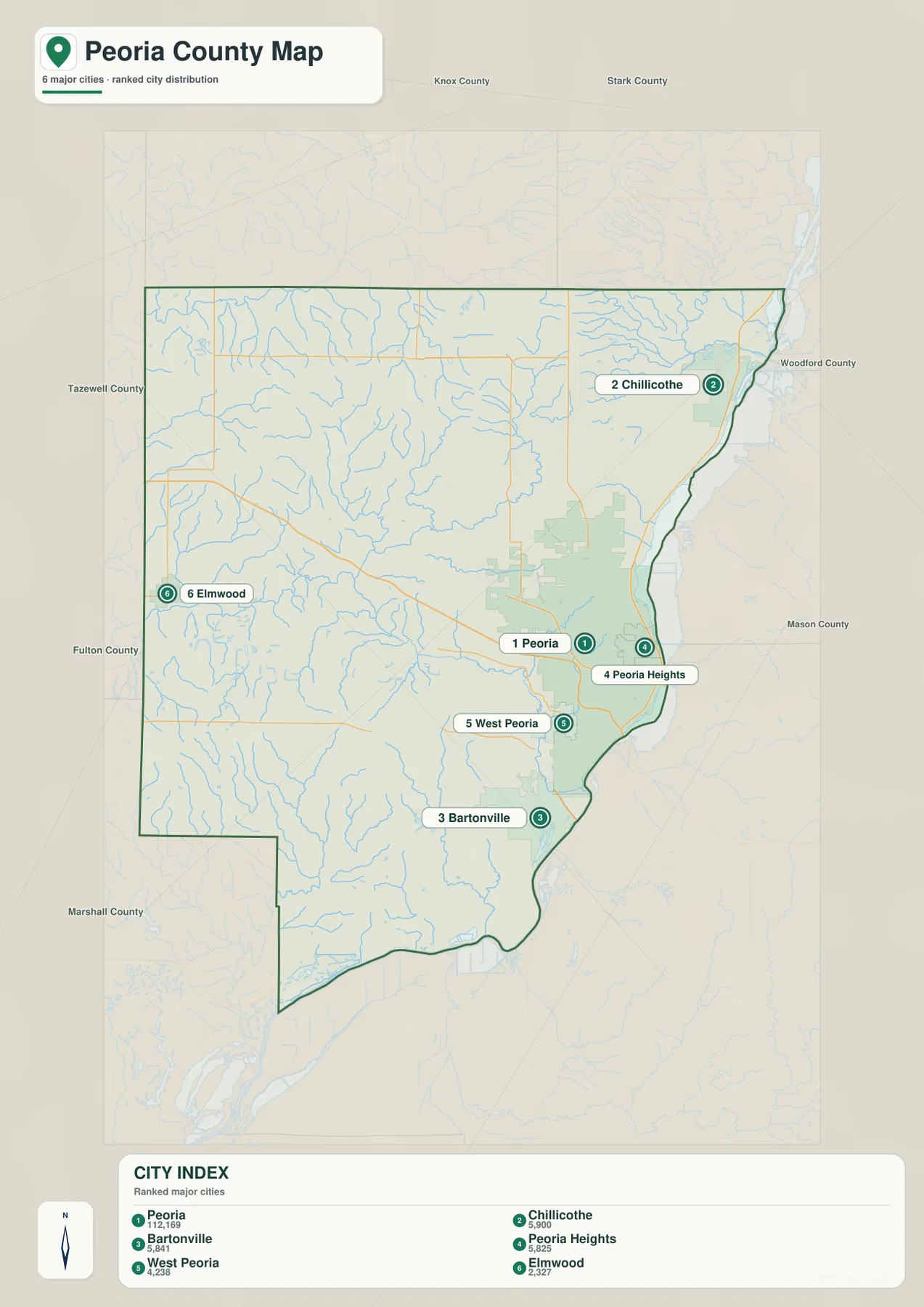
The general county map adds the smaller places needed to understand the gaps. Dunlap, Brimfield, Princeville, Hanna City, Glasford, Mapleton, and Kingston Mines all occupy different parts of the county between the six ranked communities. Reading the two settlement maps together makes the contrast between the Peoria metro edge and the rural western interior much easier to see.
Illinois River lowlands meet a deep Kickapoo Creek valley west of Peoria
The terrain and water map is anchored by the Illinois River along the entire eastern side of Peoria County. Broad water and lowland areas line that edge, and Glen Oak Lagoon is labeled near the Peoria side. The official county profile also emphasizes the river’s importance to Peoria County and notes more than 9,000 acres of surface water from the Illinois River and man-made lakes.
Inland, Kickapoo Creek creates the most prominent valley. West Fork Kickapoo Creek approaches from the west, with Walnut Creek, Timber Creek, and Jubilee Creek occupying the same general drainage area. The combined valley cuts deeply through high terrain toward Peoria, which is why it appears as a long green corridor on the elevation map rather than as a minor stream line.
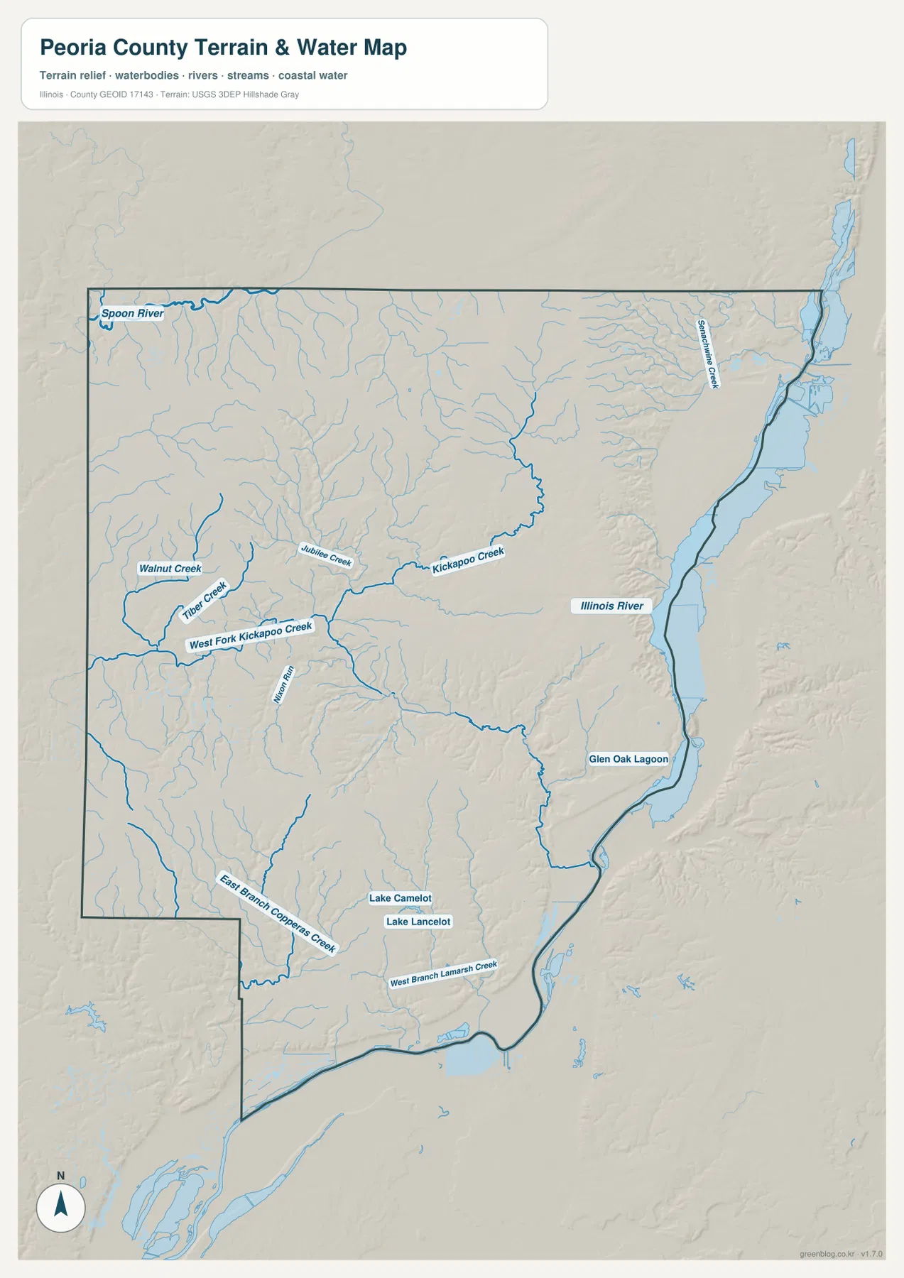
Southern Peoria County includes Lake Camelot and Lake Lancelot, with East Branch Copperas Creek and West Branch Lamarsh Creek cutting the surrounding interior. Spoon River is labeled near the northwestern edge, showing that not every drainage line heads directly toward the Peoria riverfront. This map is a general geographic water reference, not a flood-risk map, legal water-boundary product, navigation chart, or drainage-engineering document.
From 130 m river flats to 254 m uplands cut by narrow ravines
The elevation map reports an actual range of about 130 to 254 meters and a mean near 198 meters. The lowest dark-green terrain follows the Illinois River along the eastern boundary. Immediately west of that lowland, steep slopes and narrow ravines rise into tan and brown uplands, producing a particularly strong contrast around the Peoria and Chillicothe sides of the county.
The west and northwest are generally high, but they are not flat. Small tributaries repeatedly cut into the uplands, and the Kickapoo Creek valley creates the most obvious interior low corridor. Southern terrain drops again toward the Illinois River near Mapleton and Kingston Mines. Peoria County is therefore better understood as high interior ground dissected by streams beside a major river lowland, rather than as a simple surface that rises steadily from east to west.
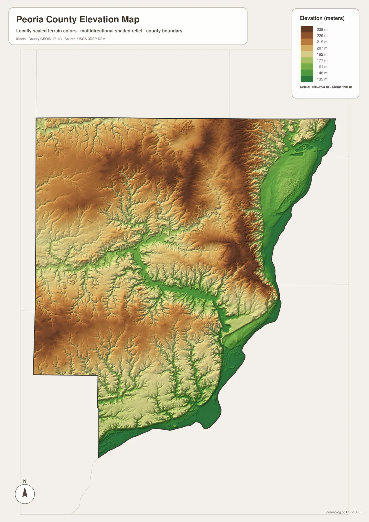
The elevation surface is generalized for county-scale comparison and should not be treated as survey-grade height, parcel elevation, or engineering data. For ordinary map reading, however, it explains the water network well. Illinois River, Kickapoo Creek, and the western tributaries align with lower green corridors, while the broad brown areas between them represent higher rolling ground.
Follow Peoria toward Chillicothe and Elmwood to compare river and upland settings
Peoria is the best place to connect the four map views. The county map shows a dense network of roads and closely spaced communities around the city. Moving north to Chillicothe keeps the reader in the Illinois River corridor but leaves the main metropolitan cluster. Moving west toward Elmwood does the opposite: the road network thins, settlements spread out, and the terrain rises into a much broader inland setting.
The water and elevation maps explain why those places feel different. Peoria and Chillicothe sit close to the low river edge and steep bluff zone, while Elmwood is surrounded by higher interior terrain. Kickapoo Creek adds another deep low corridor west of Peoria, cutting the uplands before reaching the urban side. Following the same places across the maps makes the east-west contrast easier to understand than reading each map type as a separate inventory.
Frequently Asked Questions
Why are Peoria and Chillicothe so low on the elevation map?
Both are close to the Illinois River corridor. Broad river flats occupy the eastern edge of the county, and the land rises sharply just west of them into bluff and upland terrain. Around Peoria, the Kickapoo Creek valley extends another low corridor inland, creating an especially strong contrast with the higher western county.
Which maps best show the difference between Peoria and Elmwood?
Use the county map together with the elevation map. Peoria sits in a dense urban area close to the Illinois River, Peoria Heights, West Peoria, and Bartonville, while Elmwood stands alone near the western edge. The elevation view adds the physical difference: Peoria is beside low river terrain and steep bluffs, while Elmwood is surrounded by higher inland ground.
What files are included in the downloadable ZIP?
The ZIP contains four high-resolution JPG files: the county and road map, ranked city map, terrain and water map, and elevation map. Each image is 2572 × 3638 pixels. Smaller WebP versions are used in the article for faster viewing, while the JPG files are better for close inspection and print. The water and elevation maps are general geographic references rather than flood, legal-boundary, survey, or engineering products.
Map File Information
Download the Peoria County county map, ranked city map, terrain and water map, and elevation map together as high-resolution JPG files.
- Included Files: Use only the versions confirmed in the article and supplied images
- File Type: Use the confirmed download contents
- Intended Use: Printing, education, presentations, and map-based projects
Related Maps
Sources and references
- U.S. Census Bureau TIGER/Line Shapefiles – county boundaries, roads, and place reference
- USGS National Hydrography – Illinois River, streams, lakes, and other hydrography reference
- USGS 3D Elevation Program – elevation and terrain reference
- Peoria County – About the County – official county overview of the Illinois River, river bluffs, prairie-like interior, communities, and surface water
- Peoria Park District – Peoria RiverFront – official local information for the Peoria riverfront
Green Map creates custom-edited map images using open geographic data sources such as geoBoundaries, Natural Earth, OpenStreetMap, and government open data.
These maps are edited visual materials, not raw data files, and are provided for education, documents, presentations, and graphic reference.