The Fulton County, Illinois map files on this page can be downloaded as one ZIP containing four high-resolution JPG images, while the WebP versions below provide quick browser previews. The county is easiest to understand when its roads, river valleys, and higher interior ground are viewed together: Canton sits in the east-central area, Farmington anchors the north, and Lewistown provides a useful reference farther south. The Spoon River and its tributaries cross the interior, while the Illinois River forms a long lowland edge along the east and southeast, creating a clear contrast between river valleys and higher ground.
The general map is best for finding communities and road numbers, but it does not tell the whole geographic story. A separate city index isolates six mapped places, a terrain-and-water view emphasizes named creeks, lakes, and the two major river systems, and the elevation layer shows a broad range from about 130 to 241 meters with a mapped mean of 183 meters. Comparing the same county across these views makes it clear why some places sit on higher ground while river corridors occupy noticeably lower terrain.
Visitors looking for a printable or enlarged reference can use the browser images as previews and then open the JPG package for finer labels. The archive follows the supplied map set exactly: a county road-and-place map, a ranked city map, a terrain-and-water map, and an elevation map. Each original image measures 2572 × 3638 pixels, which provides considerably more detail than the reduced WebP previews shown in the article.
Table of Contents
The Illinois River edge gives eastern Fulton County a different shape and elevation
One of the most distinctive features on the supplied maps is the low eastern and southeastern side of Fulton County. The Illinois River runs along a long portion of this edge, and the elevation map colors the adjacent ground in the lowest green classes. The county boundary does not simply follow a straight north-south line: it bends around the river-side terrain and includes an eastward extension in the middle of the county. That irregular outline is much easier to recognize when the boundary and elevation maps are compared side by side.
Several smaller water features reinforce this river-oriented landscape. Slim Lake, Big Lake, and Beebe Lake are labeled near the eastern side, while Patterson Bay and Mathew Bay appear near the county’s southern end. These labels are useful for orientation because they sit close to the broad Illinois River lowland. They should not be read as current navigation or access information, however; the supplied map does not show depth, real-time water level, boat ramps, property access, or flood probability.
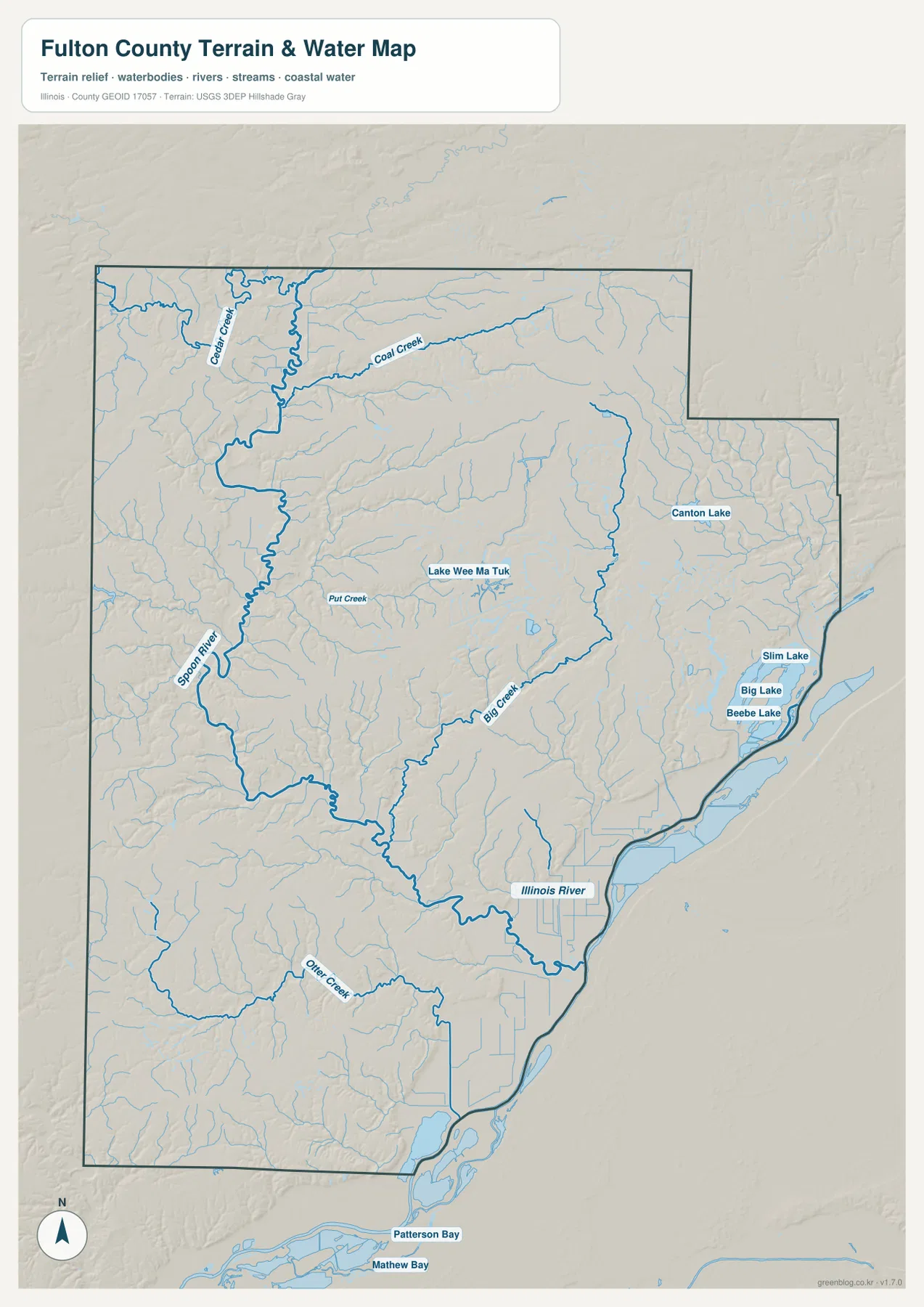
The Illinois River is only part of the drainage story. The Spoon River enters from the northwest and follows a winding interior valley toward the lower eastern side. Cedar Creek and Coal Creek are named in the north, Put Creek appears in the central interior, Big Creek crosses the middle and eastern area, and Otter Creek is labeled farther south. The terrain shading around these channels shows narrow lower corridors cutting between higher ridges. Even where a stream name is small, its valley often remains visible because the relief changes around it.
Canton and Farmington sit near some of the county’s higher interior ground
The elevation layer reports an actual mapped range of roughly 130–241 meters and a mean of 183 meters. Darker brown terrain is concentrated in the north and northeast, with broad higher areas around and between the Farmington and Canton parts of the county. By contrast, the Spoon River valley forms a long green corridor through the interior, and the Illinois River side drops to an even broader low plain. The result is a strong local contrast: communities and roads may be only a short map distance apart while occupying noticeably different terrain.
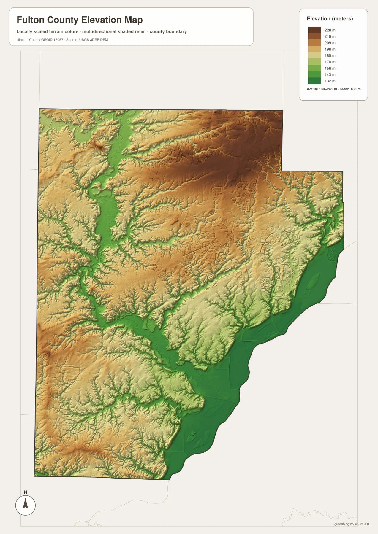
Lewistown occupies a different setting from Canton and Farmington. On the elevation map, several lower drainage corridors converge through the south-central interior, and the surrounding ridges are broken into smaller shapes. Astoria and Vermont lie farther to the southwest, where the land is not as low as the Illinois River plain but still contains many incised creek valleys. The map is useful for broad county-scale comparison, not for determining the exact elevation of a building site, road grade, or property corner. Survey, engineering, or construction work should use original elevation data and site-specific measurements.
Road numbers connect Canton, Lewistown, Cuba, and the smaller communities
The general county map places the road network back on top of the geography. Route 9 crosses the central-eastern area through Canton and continues toward Banner, while Route 97 runs north-south through the Canton area toward Farmington and the county’s northern side. Route 116 is shown near the north edge, with Avon and Route 41 near the northwest. These lines make Canton the easiest starting point for understanding the northeast and central road pattern.
Farther south, Lewistown sits near a cluster of routes that helps orient the lower half of the county. Routes 100 and 136 appear around the Lewistown area, and Route 78 continues southeast toward the Illinois River lowlands. West of Lewistown, the map identifies Smithfield and Table Grove, while Vermont and Astoria provide reference points near the southwest. Route 24 reaches Astoria, and Route 53 is visible along the western side. Cuba lies between the Canton and Lewistown areas and is connected with Route 95 on the supplied map.
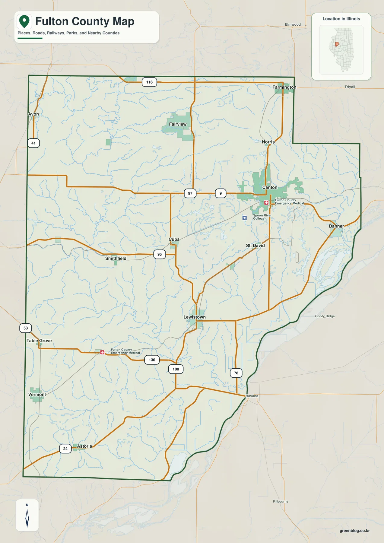
Other labels add local context without turning the map into a dense street atlas. Norris and St. David appear near the eastern half, Fairview is north of the center, and Spoon River College is marked southwest of Canton. Because the map is designed as a county reference, it is most useful for relative position, not turn-by-turn navigation. Small local roads, temporary closures, and current traffic conditions are outside its scope, so a current transportation source should be used for actual driving decisions.
The six-city index separates settlement pattern from road detail
The city map removes many labels and ranks six places from the supplied index. Canton is listed first at 13,144, followed by Farmington at 2,050, Lewistown at 1,781, Cuba at 1,004, Astoria at 984, and Vermont at 698. Those values are best treated as the figures used by this map’s city index rather than as a claim about the latest official population count. Their main purpose here is to show the relative scale and distribution of the mapped communities.
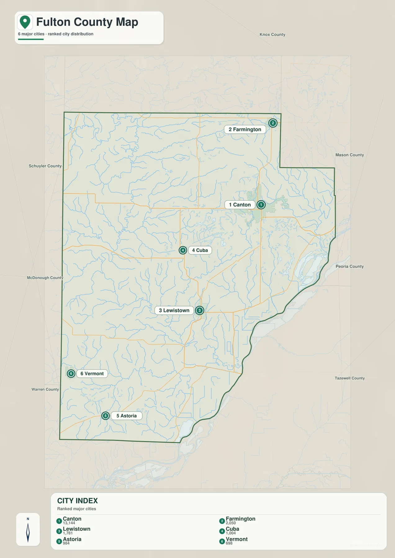
The pattern is geographically useful even without treating the numbers as current census estimates. Canton and Farmington occupy the eastern and northern portions of the county, Lewistown sits farther south, Cuba marks the western interior, and Astoria and Vermont lie near the southwest. The six locations are not clustered into one compact urban corridor. Instead, they provide reference points across a large north-south area, which is why the city map can be easier to use than the full road map when the question is simply, “Where are the main mapped communities in relation to one another?”
Choose the file by question: location, cities, waterways, or relief
Use the general map when a place needs to be matched with a numbered route or the county boundary. It is the most efficient file for locating Canton on Routes 9 and 97, following the Lewistown area toward Routes 100 and 136, or finding Astoria near Route 24. The ranked city map is cleaner when the road network is secondary and the goal is to compare Canton, Farmington, Lewistown, Cuba, Astoria, and Vermont as a set.
For physical geography, the terrain-and-water map and the elevation map answer different but complementary questions. The water view names the Spoon River, Illinois River, Big Creek, Cedar Creek, Coal Creek, Otter Creek, Canton Lake, Lake Wee Ma Tuk, and several smaller eastern water bodies. The elevation view removes most of those labels and makes the high-low contrast much stronger. Checking both makes it easier to see that the lowest corridors are associated with the main river valleys, while large parts of the northern and northeastern interior stand higher.
The reduced WebP images are convenient for browsing, but road shields and small creek labels can become difficult to read when the page is viewed on a narrow screen. The downloadable archive contains the four original JPG files at 2572 × 3638 pixels each. They are better suited to enlargement, A3-oriented layouts, classroom handouts, presentations, and side-by-side comparison with neighboring county maps. The files are reference graphics rather than GIS layers, legal boundary documents, flood maps, or survey products.
Frequently Asked Questions
Why does Canton rank first on the supplied city map?
The city index used in the supplied map lists Canton at 13,144, well above Farmington, Lewistown, Cuba, Astoria, and Vermont. The safest interpretation is that these are the figures used to rank the six mapped places in this graphic. For a current official population count, consult the latest census or local government data rather than treating the map index as a live demographic table.
Why is the eastern edge so low on the elevation map?
The lowest green terrain follows the Illinois River and its broad adjacent lowland, while another low corridor traces the Spoon River through the interior. Higher brown terrain is much more common in the north and northeast. The map therefore shows a clear county-scale difference between river valleys and the higher interior, although it is not accurate enough for parcel-level elevation or engineering decisions.
Can the terrain-and-water map be used for flood or boating decisions?
No. It is a geographic reference showing the relative positions of rivers, creeks, lakes, bays, and terrain. It does not include flood probabilities, current river stages, channel depth, navigation status, launch access, or property restrictions. Use current USGS and local information when the decision involves safety, water conditions, or access.
Map File Information
The ZIP contains the Fulton County road-and-place map, ranked city map, terrain-and-water map, and elevation map as original high-resolution JPG files.
- Included Files: County, city, water, and elevation maps
- Printable Size: 2572 × 3638 pixels each
Related Maps
Sources and reference data
The county-specific descriptions above are based primarily on the four supplied Fulton County maps. The following official sources are useful for checking government information, administrative boundaries, hydrography, and elevation data.
- Fulton County official website – county government and local background
- U.S. Census Bureau TIGER/Line Shapefiles – administrative and geographic boundary data
- USGS National Hydrography – river, stream, and water-feature reference data
- USGS 3D Elevation Program – elevation and terrain source data
Green Map creates custom-edited map images using open geographic data sources such as geoBoundaries, Natural Earth, OpenStreetMap, and government open data.
These maps are edited visual materials, not raw data files, and are provided for education, documents, presentations, and graphic reference.