Clinton County in southwestern Illinois is best oriented around two features that meet near Carlyle: the east-west US 50 town corridor and the Kaskaskia River-Carlyle Lake system. Trenton, Aviston, Breese, and Carlyle line up across the northern-middle part of the county, while New Baden, Albers, Germantown, Bartelso, and Hoffman form a second band farther south. The eastern half changes character quickly because Carlyle Lake occupies such a large area and the Kaskaskia drainage creates broad low ground around it.
The supplied map set follows that transition from roads and towns to water and relief. The detailed overview is useful for tracing US 50 and Route 161, the city graphic strips the pattern down to six major places, the terrain sheet emphasizes Carlyle Lake and its tributaries, and the elevation image shows how the river and southern lowlands sit below higher ground toward the northwest and outer east. High-resolution JPG originals of all four maps are packaged in one ZIP download for larger viewing, printing, classroom material, or presentation use.
Clinton County’s official website states that the county was established in 1824 and highlights Carlyle Lake as one of its defining resources. The county’s comprehensive plan identifies Carlyle as the county seat. That combination makes Carlyle unusually useful as a map reference: the courthouse is labeled there, US 50 and Route 127 meet nearby, and the largest water feature in the county begins immediately to the northeast.
Table of Contents
US 50 strings the northern towns together
On the county overview, US 50 enters at Trenton and continues through Aviston and Breese before reaching Carlyle. Saint Joseph’s Hospital is labeled in Breese, while the Clinton County Courthouse appears in Carlyle. Because those places sit on one continuous east-west line, the road provides a simple way to remember the county’s northern-middle settlement pattern without starting from dozens of local roads.
Carlyle is also the point where Route 127 runs south through the central part of the county. Farther south, another major east-west line links New Baden, Albers, Germantown, Bartelso, Hoffman, and the Centralia side; the map labels that corridor 161. Route numbers 64, 177, and 160 appear around the southwestern corner. Together these roads give Clinton County two broad town bands, one built around US 50 and another farther south.
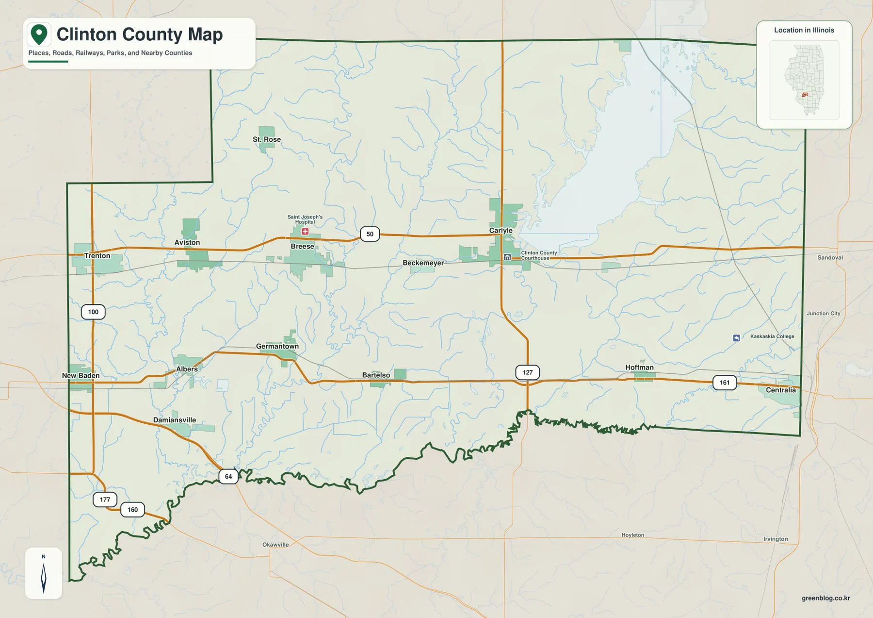
The eastern side refuses to fit the same road-grid pattern. Carlyle Lake spreads across a large portion of the northeast, and smaller waterways branch around the reservoir and below Carlyle. The road map therefore shifts from town-centered detail in the west to water-dominated geography in the east. Looking at the blue stream lines together with the roads makes that contrast obvious even before switching to the terrain map.
Carlyle combines county-seat, road-junction, and lake reference
The Clinton County comprehensive plan identifies Carlyle as the county seat, and the supplied map places the courthouse there. It is also where US 50 and Route 127 meet close to the Kaskaskia River and the reservoir. Keeping Carlyle fixed while moving between the road, water, and elevation maps is one of the easiest ways to keep the county geography consistent.
Breese and New Baden lead the six-city index
The city-distribution graphic emphasizes six places rather than every municipality on the detailed map. Breese is ranked first, New Baden second, Carlyle third, Trenton fourth, Aviston fifth, and Germantown sixth. The printed CITY INDEX gives values of 4,301 for Breese, 3,463 for New Baden, 2,980 for Carlyle, 2,664 for Trenton, 2,387 for Aviston, and 1,350 for Germantown.
No reference year or census date appears beside those figures, so this page does not treat them as current population counts. Their geographic arrangement is more dependable than their age: Trenton, Aviston, Breese, and Carlyle follow the US 50 line, New Baden sits well to the southwest, and Germantown occupies the interior south of Breese. That pattern remains useful even when the numerical index is treated only as a label supplied with the graphic.
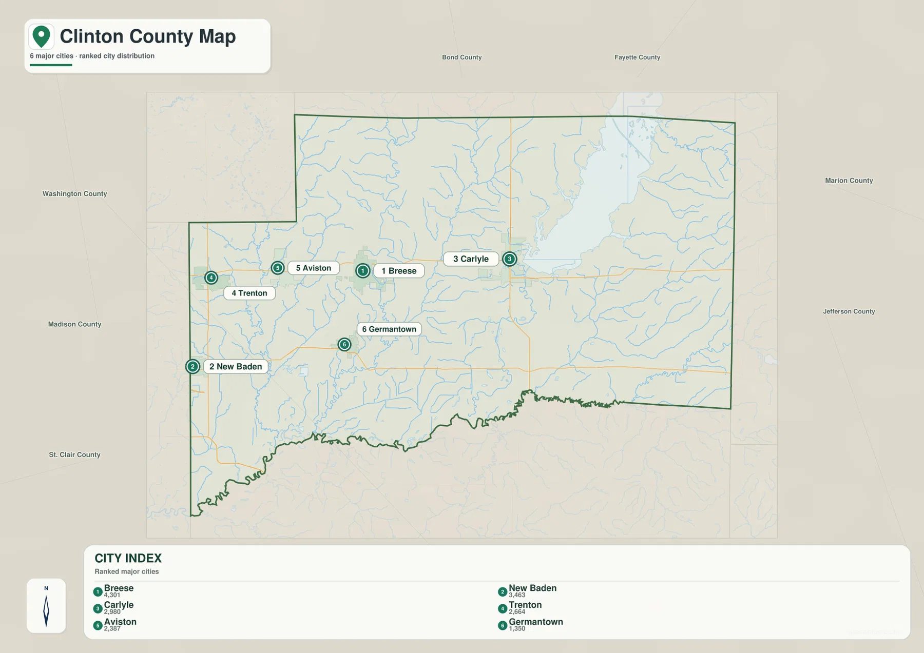
The simplified layout also shows why Clinton County does not have one compact urban center. Four of the six highlighted places form a long western-to-eastern chain, while New Baden and Germantown sit south of that line. Carlyle is the eastern anchor closest to the lake. This spacing is a useful mental framework before returning to the smaller municipalities and local road network on the detailed sheet.
Use a dated source for current population
A current population table requires a source with a clear reference date, such as the U.S. Census Bureau. The CITY INDEX shown here does not provide that date. It is therefore used only to describe how the supplied graphic ranks and places the six labeled communities.
Carlyle Lake dominates the Kaskaskia water system
The terrain-and-water map is dominated by Carlyle Lake in the northeast. The water body is labeled both Carlyle Lake and Carlyle Reservoir on the supplied image, with Kaskaskia River continuing south below the lake. East Fork Kaskaskia River enters the system from the northeast, making it clear that the reservoir belongs to a larger river network rather than standing alone.
The western half has a different drainage pattern. Sugar Creek runs along the west side, while Shoal Creek and Beaver Creek descend through the interior. Lake Branch appears as a smaller western tributary. Near the Kaskaskia River, Lake Joy, Blanke Lake, Bear Lake, and Goose Lake form a close group of named water bodies. Sportsman Lake sits in the northwest, and Crooked Creek is labeled near the southeastern edge.
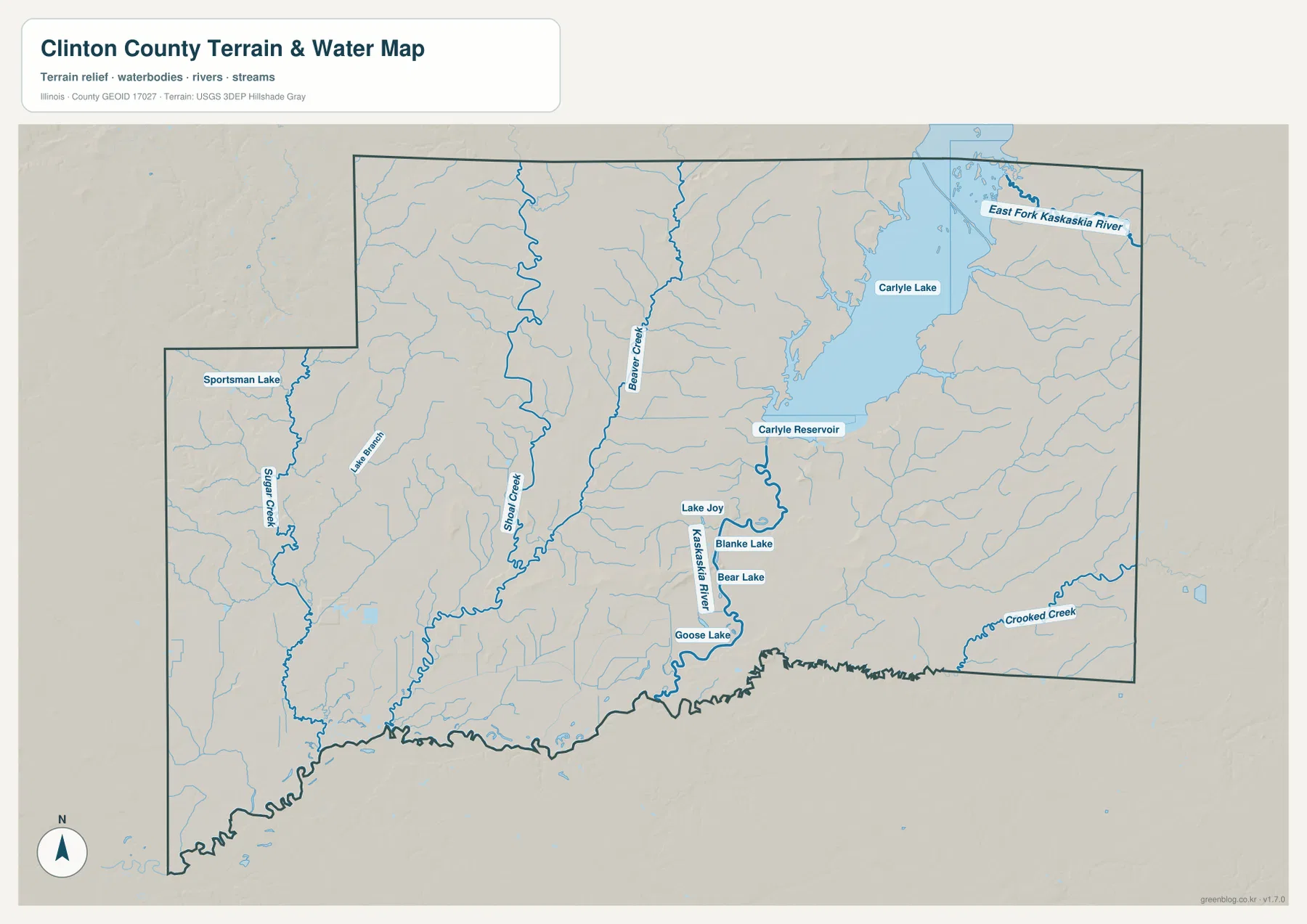
The U.S. Army Corps of Engineers describes Carlyle Lake as a reservoir on the Kaskaskia River completed in 1967, with more than 26,000 acres of water. The project serves flood-control, water-supply, water-quality, recreation, and conservation functions. Clinton County’s own website also presents the lake as a major county feature. Those official descriptions match the map’s visual message: the lake is large enough to reorganize the geography of the county’s entire eastern side.
A static water map does not give current lake conditions
The terrain sheet locates the reservoir, river, creeks, and smaller lakes, but it does not report today’s lake level, dam releases, flood risk, boating restrictions, or individual access conditions. Those questions should be checked against current U.S. Army Corps of Engineers or USGS information before making a safety or recreation decision.
Low Kaskaskia country sits between higher outer ridges
The elevation map puts the broad water system into relief. Dark green covers much of the southern county and follows the Kaskaskia corridor below Carlyle Lake. Several creek valleys also appear as narrow green cuts through the western interior. By contrast, the northwest corner contains a broad area of orange and brown high ground, and higher terrain returns along parts of the far eastern side.
The map prints an actual countywide range of about 117 to 180 meters and a mean near 138 meters. The legend itself uses narrower color bands from roughly 122 to 155 meters, while the separate “Actual” line records the broader minimum and maximum in the dataset. Those endpoints summarize Clinton County as a whole; they are not precise elevations for Trenton, Carlyle, New Baden, Germantown, or any individual site.
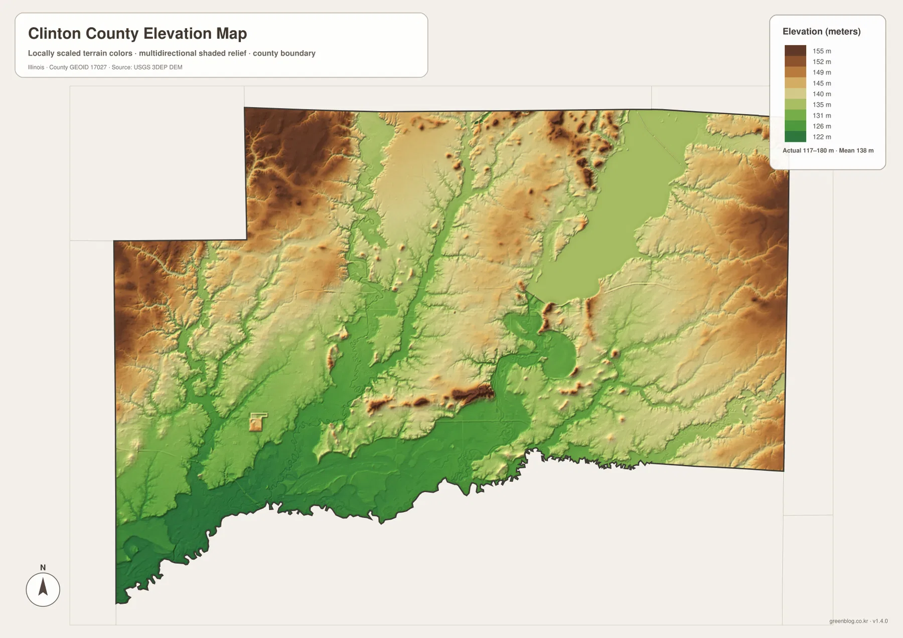
When the water and elevation views are compared, the green low corridors align with Kaskaskia River, Shoal Creek, Beaver Creek, and other drainage lines. Carlyle Lake occupies the largest low-water setting, while the northwest uplands and eastern ridges rise well above the broad southern floor. The county therefore has a gentle but meaningful relief pattern that is easy to miss on the road map alone.
117 to 180 meters describes the county, not a town
A building lot, bridge, road grade, drainage design, or other site-specific project needs point-level elevation data or a professional survey. The colored image is useful for comparing the Kaskaskia lowlands with higher outer terrain, but the 117- and 180-meter endpoints should not be assigned to a named community.
Follow US 50, then switch to the lake and river
A practical way to use the set is to keep the same landmarks while changing the information layer. Begin on US 50 and trace Trenton, Aviston, Breese, and Carlyle. The city graphic then reduces the county to six prominent settlement labels. From Carlyle, move to the terrain map and follow the reservoir north and Kaskaskia River south; this connects the town corridor directly to the county’s largest natural and engineered water feature.
The elevation image completes the comparison. Higher ground is more noticeable around the northwest and outer east, while the lake, Kaskaskia River, and much of the southern county occupy lower terrain. New Baden and Germantown also lie in a landscape cut by low creek corridors. Seeing roads, settlement spacing, water, and relief together gives a more accurate picture of Clinton County than any single sheet can provide.
Use current transportation sources for driving conditions, dated Census releases for population, Corps of Engineers or hydrologic sources for Carlyle Lake operations and water levels, and point-level elevation data for site work. Within those limits, the maps are well suited to printed references, lessons, presentations, and advance orientation across Clinton County.
Frequently Asked Questions
What is the county seat of Clinton County, Illinois?
Carlyle is the county seat. Clinton County’s comprehensive plan identifies Carlyle as the county seat, and the supplied overview labels the Clinton County Courthouse there. Carlyle is also a convenient geographic reference because US 50, Route 127, Kaskaskia River, and Carlyle Lake all meet in the same general area.
Is Carlyle Lake a reservoir on the Kaskaskia River?
Yes. The U.S. Army Corps of Engineers states that the Carlyle Lake project was built on Kaskaskia River and completed in 1967. The supplied terrain map also shows Kaskaskia River continuing south below the reservoir and East Fork Kaskaskia River connecting from the northeast.
Does 117 to 180 meters give Carlyle’s elevation?
No. The elevation image identifies 117–180 m as the actual range across the Clinton County dataset and gives a mean of about 138 m. Exact elevation for Carlyle or any specific road, property, or structure requires point-specific elevation or survey data.
Sources and Reference Material
The article uses the supplied Clinton County maps together with the official references below. For current Carlyle Lake operations, water levels, road conditions, legal boundaries, or exact point elevations, consult the responsible agency’s latest data rather than relying on a static county reference map.
- Clinton County Official Website – county establishment, community overview, and Carlyle Lake context
- Clinton County Comprehensive Plan – county-seat, history, transportation, and Carlyle Lake background
- U.S. Army Corps of Engineers – Carlyle Lake – lake size, project purpose, recreation, and current project information
- USGS National Hydrography – river, stream, and lake reference data
- USGS 3D Elevation Program – elevation and terrain data
Map File Information
The ZIP file contains the high-resolution JPG originals for the Clinton County overview, city map, terrain-and-water map, and elevation map. Each landscape image measures 3,638 × 2,572 pixels, preserving the US 50 town labels, smaller creek names, Carlyle Lake shoreline, and elevation colors more clearly when enlarged or printed.
- Included Files: 4 high-resolution JPG maps
- Printable Size: 3,638 × 2,572 pixels each
Related Maps
Green Map creates custom-edited map images using open geographic data sources such as geoBoundaries, Natural Earth, OpenStreetMap, and government open data.
These maps are edited visual materials, not raw data files, and are provided for education, documents, presentations, and graphic reference.