Carroll County in northwestern Illinois changes quickly from the Mississippi River edge to rolling uplands farther east. Savanna and Thomson sit on the western river side, Mount Carroll occupies the interior, and Lanark, Milledgeville, and Shannon extend toward the east and northeast. The road map looks fairly open, but the terrain and water maps reveal a dense network of creek valleys. Low river-margin ground is followed almost immediately by short ridges, and the eastern half rises into a broader belt of higher rolling country.
This Carroll County Illinois Map page combines a detailed county overview, a ranked-city distribution map, a terrain-and-water map, and an elevation map. You can download high-resolution JPG versions of all four supplied maps together in one ZIP file for printing, classroom work, presentations, or closer viewing. The maps are designed for county-scale orientation rather than live traffic, parcel boundaries, flood decisions, navigation, or survey-grade elevation.
The Illinois State Archives records Carroll County as established in 1839 and Mount Carroll as the current county seat. Carroll County’s official yearbook explains that Savanna initially won the county-seat vote, but Mount Carroll became the seat after another vote in 1843 and has remained so. Those two places make useful map anchors: Savanna is tied directly to the Mississippi River, while Mount Carroll sits inland among roads, creeks, and rolling terrain.
Table of Contents
Savanna and Mount Carroll anchor the western and central county
The county overview is easiest to enter from the west. Savanna sits beside the Mississippi River where the county boundary bends with the channel, and Route 84 follows the river side north and south. Moving east from Savanna brings the map to Mount Carroll, where roads split toward Lanark and Chadwick. The shift between those two towns is also a transition from river-margin low ground into a more dissected inland landscape.
Thomson lies farther south along the river, while Lanark and Shannon occupy the northeastern side. Milledgeville is clearly separated in the southeast. Route numbers such as 72, 73, 84, 64, 52, 40, and 78 create a simple frame for locating the towns, although the overview is not a live traffic product and does not show current closures, construction, or lane conditions.
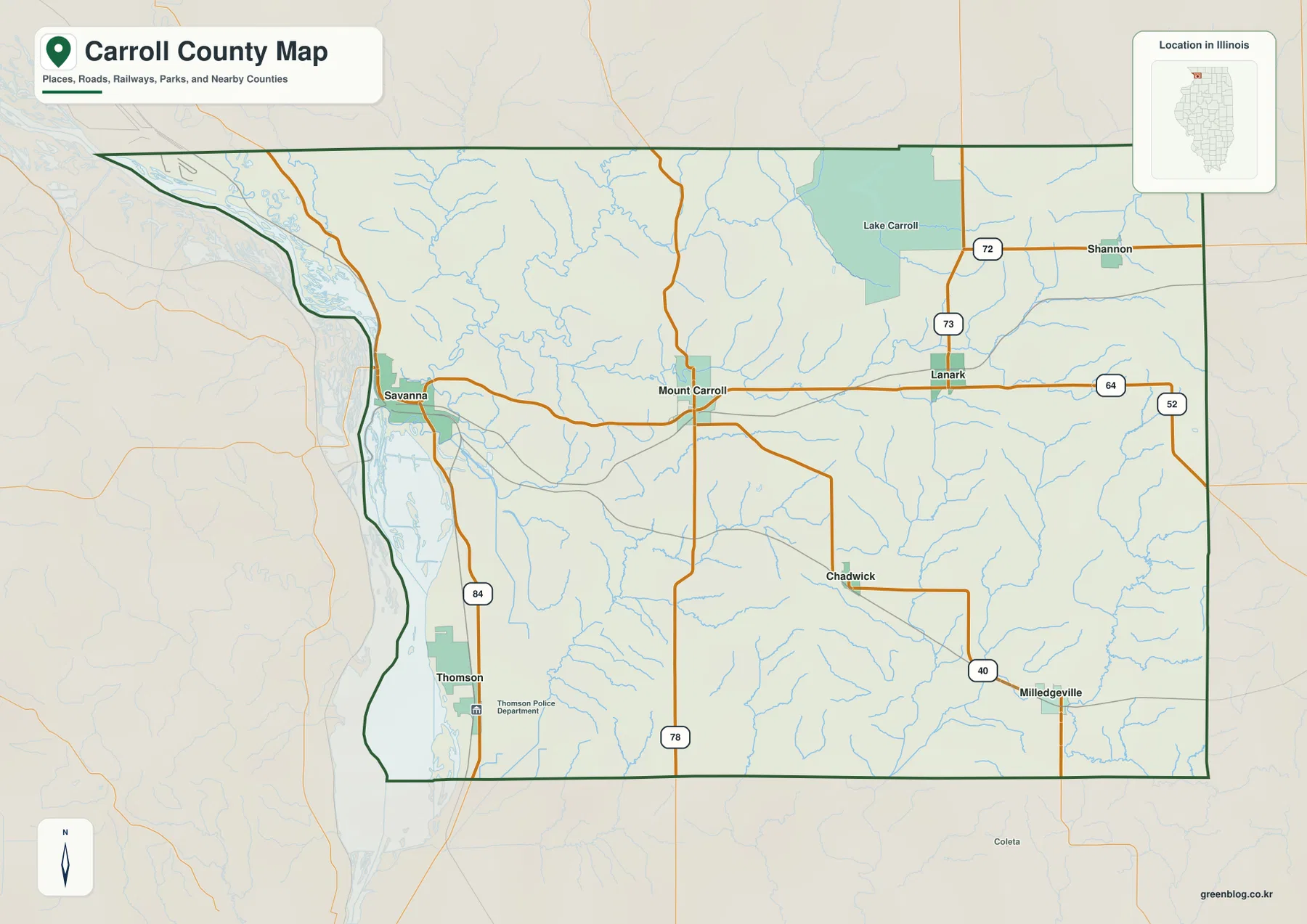
Lake Carroll appears in the northeastern part of the county as a large interior landmark, while the river side remains broad and low. Between those areas, small blue streams branch through the central uplands. Even on the road map, the numerous drainage lines make it clear that Carroll County is not simply a flat agricultural rectangle. Short valleys and ridges shape the space between communities.
Use Mount Carroll as the inland reference point
For a first look, place Savanna on the western river edge and Mount Carroll in the interior. Lanark is east of Mount Carroll, Chadwick is southeast, and Shannon is farther northeast. That framework makes it easier to move between the detailed county map, the water map, and the elevation map without losing orientation. Exact property lines and private-access rights require official parcel or land-management information.
Six ranked places show a river-side and upland split
The city-distribution map removes most road detail and emphasizes six places. Savanna is ranked number 1, Thomson number 2, Lanark number 3, Mount Carroll number 4, Milledgeville number 5, and Shannon number 6. The printed CITY INDEX lists values of 2,816 for Savanna, 1,757 for Thomson, 1,541 for Lanark, 1,501 for Mount Carroll, 1,218 for Milledgeville, and 772 for Shannon.
The graphic does not display a census year or statistical date beside those values, so this article does not present them as current population counts. They are treated only as figures printed on the supplied city map. The spatial pattern is clear without making a population claim: Savanna and Thomson are tied to the Mississippi side, Mount Carroll and Lanark occupy the interior, Shannon is northeast, and Milledgeville is southeast.
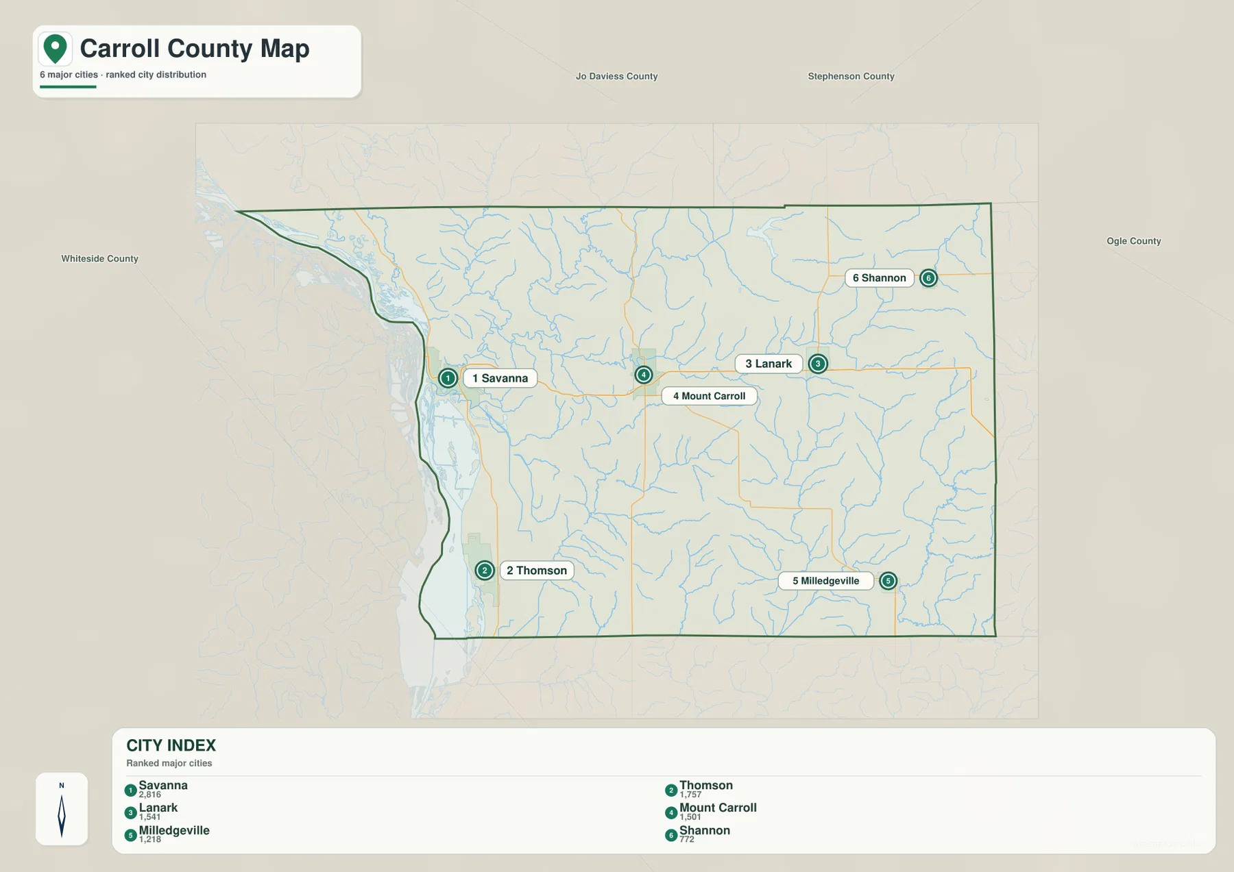
The simplified positions make the county’s east-west structure especially easy to see. Savanna and Thomson form a river-side pair, while Mount Carroll and Lanark sit much farther inland. Shannon and Milledgeville mark the northeastern and southeastern sides, giving the map useful reference points for the full width of Carroll County.
The CITY INDEX is map data, not a current census table
If a report requires current official population figures, use a dated U.S. Census Bureau source. The supplied city graphic does not identify the year behind its index. On this page, the values are used only to describe the supplied ranking and the relative prominence and location of the six labeled communities.
Plum River and a chain of water features meet the Mississippi
The terrain-and-water map makes the Mississippi side the dominant feature. Horseshoe Lake and Buffalo Lake are labeled in the northwest, while Bowens Lake and Spring Lake appear farther south along the river margin. The Mississippi River follows the western boundary, with the lower part labeled as the Upper Mississippi River. These water bodies occupy broad low ground that contrasts with the narrow inland valleys.
Plum River crosses the west-central county, and East Plum River appears farther north. Carroll Creek and Johnson Creek form long interior drainage lines, while Rock Creek and Elkhorn Creek are labeled in the southeast. Lake Carroll is the large inland lake in the northeast. Numerous unnamed tributaries fill the gaps between these features, producing a fine branching network across the rolling terrain.
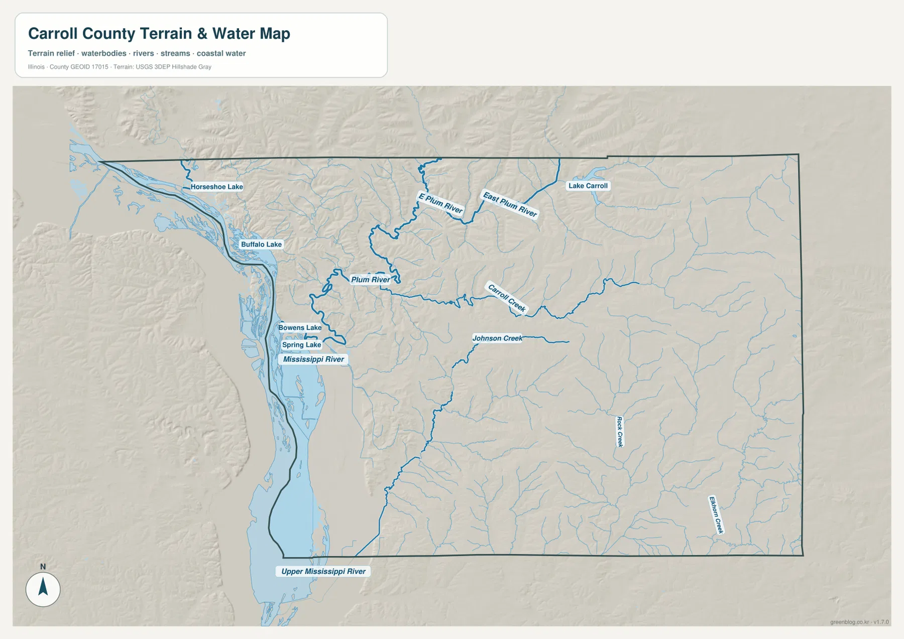
The Illinois Department of Natural Resources describes Mississippi Palisades State Park as lying about 3 miles north of Savanna along the Mississippi River, where steep limestone bluffs and deep ravines overlook the river corridor. Carroll County’s official yearbook also points to the Palisades near Savanna as a defining local landscape. Those references help explain why the western edge is more than a flat floodplain: low river ground sits immediately beside rugged bluffs and deeply cut uplands.
The water map is not a flood or navigation product
The map shows the locations of rivers, creeks, lakes, and surrounding terrain. It does not provide flood-hazard zones, live river stages, water depth, navigable channels, levee conditions, water rights, or legal access. Current USGS, Illinois DNR, and other responsible agency information should be used for safety, boating, flood, or regulatory decisions.
Elevation rises sharply away from the Mississippi lowlands
The elevation map makes Carroll County’s strongest physical contrast unmistakable. A dark-green strip follows the Mississippi River side, marking the lowest broad ground. Immediately to the east, the surface becomes much more broken, with short green valleys cutting through yellow and orange ridges. The northeastern and eastern areas contain broad belts of higher terrain, while the central county is divided by many creek valleys.
The map reports an actual countywide elevation range of about 167 to 325 meters and a mean of about 234 meters. Its color legend uses bands from roughly 178 to 292 meters, while the separate “Actual” line records the wider minimum and maximum in the underlying county dataset. Those endpoints describe Carroll County as a whole; they are not exact elevations for Savanna, Shannon, Lanark, or any specific property.
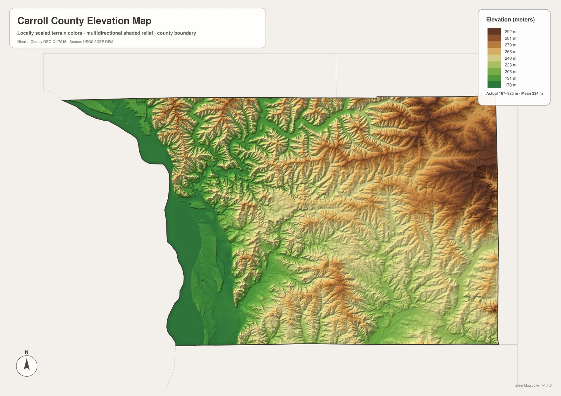
Reading the water and elevation maps together makes the valley pattern easy to recognize. Plum River and Carroll Creek follow lower green corridors through higher terrain, while the Mississippi River occupies the widest lowland. East of the river, ridges are repeatedly cut by narrow drainage lines. The combination helps explain why Savanna’s river setting and the inland towns can feel geographically different even though they are in the same county.
167 to 325 meters is a countywide range
Do not assign the low or high endpoint directly to a named town. Exact elevation for a building site, road grade, drainage design, bridge, or parcel requires location-specific source data or a professional survey. This map is designed for broad county comparison rather than precise engineering measurement.
Choosing the Carroll County map that fits the question
Use the county overview when you need Savanna, Mount Carroll, Lanark, Milledgeville, Shannon, numbered roads, county boundaries, and streams in one image. The ranked-city map is better for quickly comparing the six labeled communities. Choose the terrain-and-water map for the Mississippi River, Plum River, Lake Carroll, and the county’s creek network. The elevation map is the clearest option for comparing the low western river margin with higher eastern uplands.
A practical sequence is to begin with Savanna and Mount Carroll on the overview, then trace Routes 84, 72, and 73 toward the other towns. Next, simplify the settlement pattern with the city map. Move to the water map to find the Mississippi River, Plum River, and Lake Carroll, then finish with elevation to see how those waterways occupy lower corridors below the rolling and sometimes steep uplands.
Each map has a defined purpose. The overview is not a live-traffic or parcel product, the CITY INDEX is not presented as a current census table, the water map does not assess flood or navigation conditions, and the elevation surface is not survey-grade. Within those limits, the set works well for printed reference sheets, teaching, presentations, county orientation, and trip-planning context.
Frequently Asked Questions
What is the county seat of Carroll County, Illinois?
The Illinois State Archives lists Mount Carroll as the current county seat. Carroll County’s official yearbook explains that Savanna was initially selected in 1839, but Mount Carroll became the county seat after another vote in 1843 and has remained so.
Are the CITY INDEX values current population counts?
This page does not treat them as current population figures because the supplied map does not show a census year or statistical date beside the index. Use a dated U.S. Census Bureau source when an official current population figure is required.
Does 167 to 325 meters give Savanna’s elevation?
No. The elevation map identifies 167–325 m as the actual range across the Carroll County dataset and gives a mean of about 234 m. Exact elevation for Savanna or any specific road, property, bluff, or structure requires point-specific elevation or survey data.
Sources and Reference Material
The article uses the supplied Carroll County maps together with the official references below. For current road conditions, water information, legal boundaries, or exact point elevations, use the responsible agency’s current source data rather than these explanatory county maps.
- Carroll County Official Yearbook – county history, Mount Carroll county-seat history, and local Mississippi Palisades context
- Illinois State Archives – Carroll County – county establishment and county-seat records
- Illinois DNR – Mississippi Palisades State Park – Mississippi River bluffs and natural features north of Savanna
- USGS National Hydrography – rivers, streams, lakes, and related hydrography data
- USGS 3D Elevation Program – elevation and terrain data
Map File Information
The high-resolution JPG originals for the Carroll County overview, ranked-city map, terrain-and-water map, and elevation map are bundled in one ZIP file. Each image is a 3,638 × 2,572-pixel landscape file suitable for zooming, printed reference sheets, classroom materials, and presentation graphics.
- Included Files: 4 high-resolution JPG maps
- Printable Size: 3,638 × 2,572 pixels each
Related Maps
Green Map creates custom-edited map images using open geographic data sources such as geoBoundaries, Natural Earth, OpenStreetMap, and government open data.
These maps are edited visual materials, not raw data files, and are provided for education, documents, presentations, and graphic reference.