Calhoun County in western Illinois has one of the state’s most distinctive county shapes. The Mississippi River runs along the western side and the Illinois River along the east, leaving a long, narrow strip of land between them. Kampsville, Hardin, Batchtown, and Brussels are arranged mainly along the eastern and central corridor, while Hamburg sits closer to the western river side. Broad lowlands hug both major rivers, but a much higher, deeply cut ridge occupies the interior.
This Calhoun County Illinois Map page combines a county overview, a ranked-city map, a terrain-and-water map, and an elevation map. You can download high-resolution JPG versions of all four supplied maps together in one ZIP file for printing, classroom work, presentations, or closer viewing. The set is especially useful here because no single flat road map explains the county as well as the combination of river boundaries, short creek valleys, and the high central spine.
Calhoun County’s official website describes the county as rolling hill country between the Mississippi and Illinois rivers. The Illinois State Archives records the county as established in 1825 and lists Hardin as the county seat from 1847 to the present. Those descriptions match the supplied maps closely: Hardin provides a central eastern reference, while the county stretches far north toward Kampsville and south toward Brussels through a landscape shaped by two large rivers.
Table of Contents
Two rivers shape a long, narrow county
The county overview is defined first by its outline. The northern end is relatively broad, the middle narrows below Hardin, and the southern end opens again around the Brussels area. Much of the western edge bends with the Mississippi River corridor, while the eastern edge follows the Illinois River side. Large parts of the boundary are therefore shaped by water rather than by long straight survey lines.
Kampsville is the easiest northern town to locate. Hardin lies farther south near the eastern edge, followed by Batchtown and then Brussels in the southern half. Hamburg is the outlier on the western river side. Route 96 provides a strong northern reference, while Route 100 runs along much of the eastern side near Hardin. The road pattern is unusually linear because the county is narrow and the high interior limits easy east-west crossings.
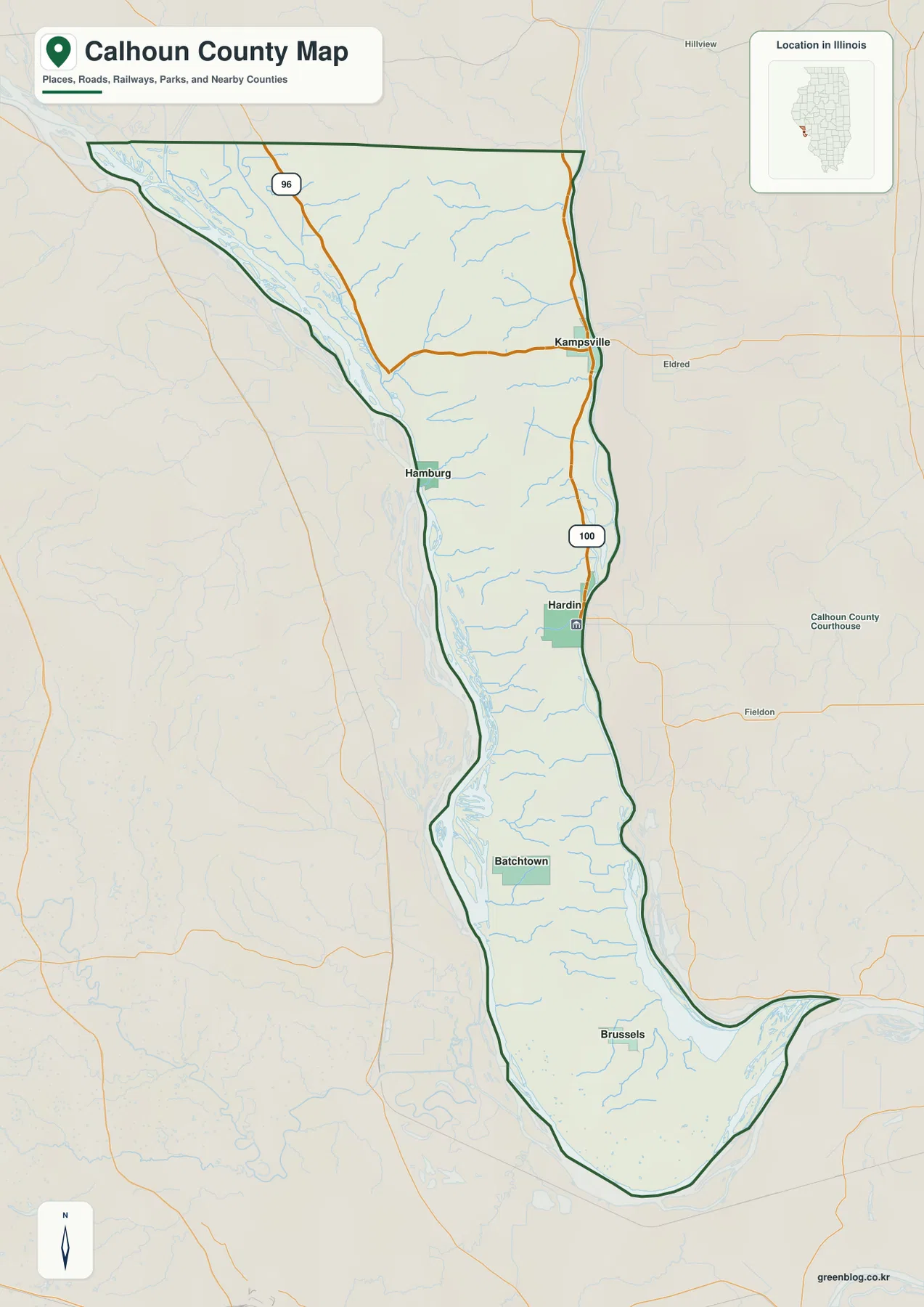
The numerous blue tributaries show why the interior should not be imagined as a flat strip between two rivers. Small creeks drop quickly from the central uplands toward low river margins on both sides. In the northern and middle county those valleys are short and closely spaced, while the southern end opens into broader low country around wetlands and river channels. Settlement and roads occupy the limited corridors between these physical features.
Hardin is the most useful middle reference
Place Hardin near the middle of the eastern side, then look north for Kampsville, southwest for Hamburg, and south for Batchtown and Brussels. The Illinois State Archives also identifies Hardin as the county seat, making it a practical civic and geographic reference. The overview does not provide live road or ferry status, legal parcel boundaries, or private-access information, so those questions require current agency sources.
Five ranked places reveal the county’s north-south spacing
The city-distribution map removes most road detail and emphasizes five places. Hardin is ranked number 1, Kampsville number 2, Batchtown number 3, Brussels number 4, and Hamburg number 5. The printed CITY INDEX lists values of 663 for Hardin, 264 for Kampsville, 237 for Batchtown, 214 for Brussels, and 68 for Hamburg.
The graphic does not display a census year or statistical date beside those figures, so this article does not present them as current population counts. They are treated only as values printed on the supplied city map. The spatial pattern is clear without making a population claim: Hardin occupies the central eastern side, Kampsville lies well to the north, Batchtown and Brussels are progressively farther south, and Hamburg sits near the western edge.
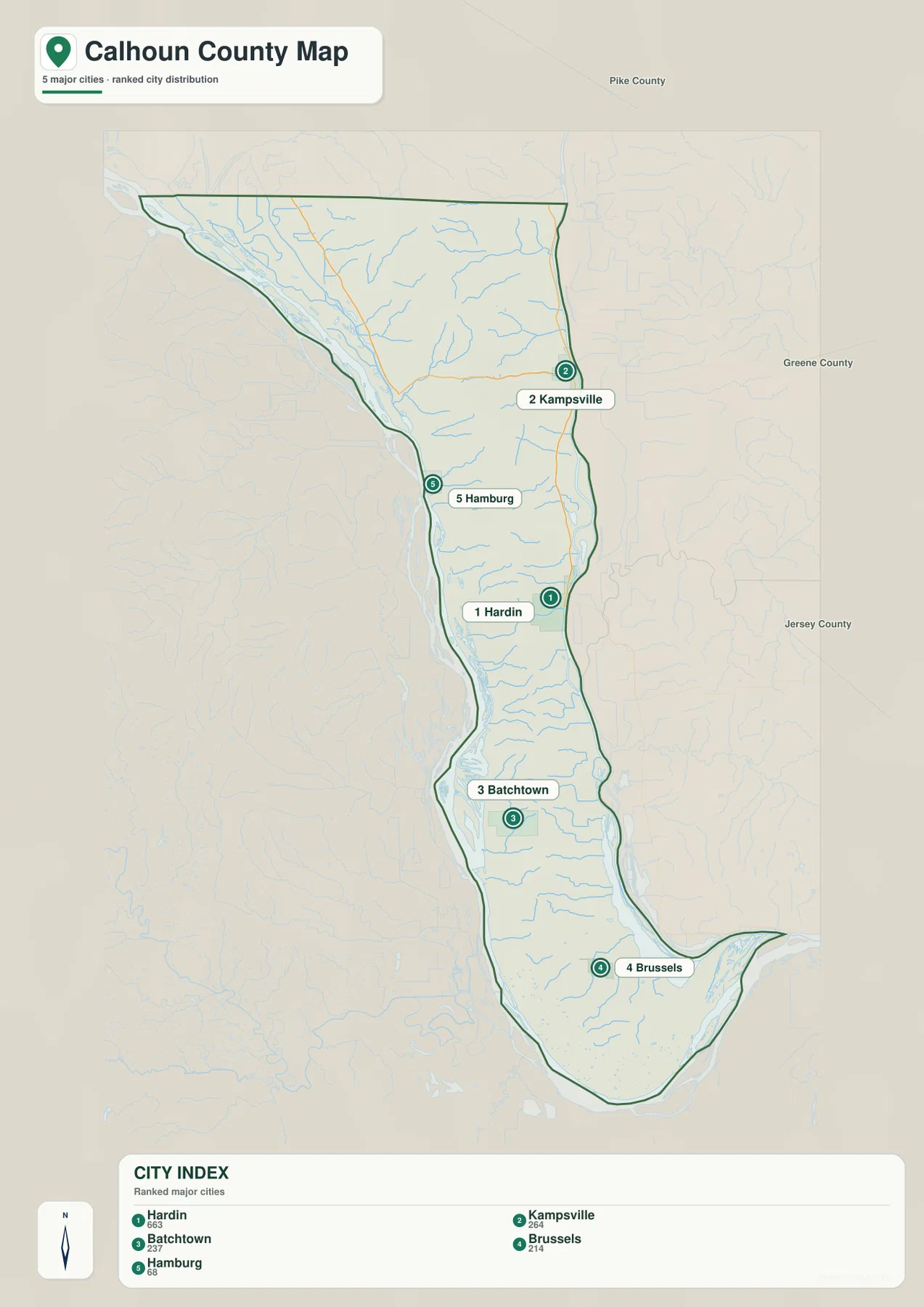
The simplified view also highlights how unusual the settlement pattern is compared with a compact square county. The places are not clustered around one center. Instead, they are separated along a narrow strip of land, with Hardin and Kampsville closer to the Illinois River side, Brussels far to the south, and Hamburg near the Mississippi side. That distribution is a direct result of the county’s elongated terrain.
The CITY INDEX is map data, not a current census table
If current official population figures are needed, use a dated U.S. Census Bureau source. The supplied graphic does not identify the year behind its index. On this page, the values are used only to describe the ranking printed on the map and the relative placement of the five labeled communities.
Short creeks descend from the central ridge to both river sides
The terrain-and-water map makes the county’s physical structure especially clear. The Sny follows the broad western lowland through the northern and central county, with Dolman Pond near the northwestern side. Bay Creek, Wildcat Hollow Creek, Hillcrest Creek, Fox Creek, Irish Creek, Indian Creek, and West Point Creek descend toward that western low country from the interior ridge.
Creeks also run east from the same uplands. East Panther Creek and Silver Creek are labeled in the northeast, while Crawford Creek and Crater Creek cross the central-eastern slope. Royal Lake stands out near the southern end, surrounded by low channels and wet ground. The pattern is not one river crossing the county from end to end; it is a central high spine shedding many short streams toward major rivers on both sides.
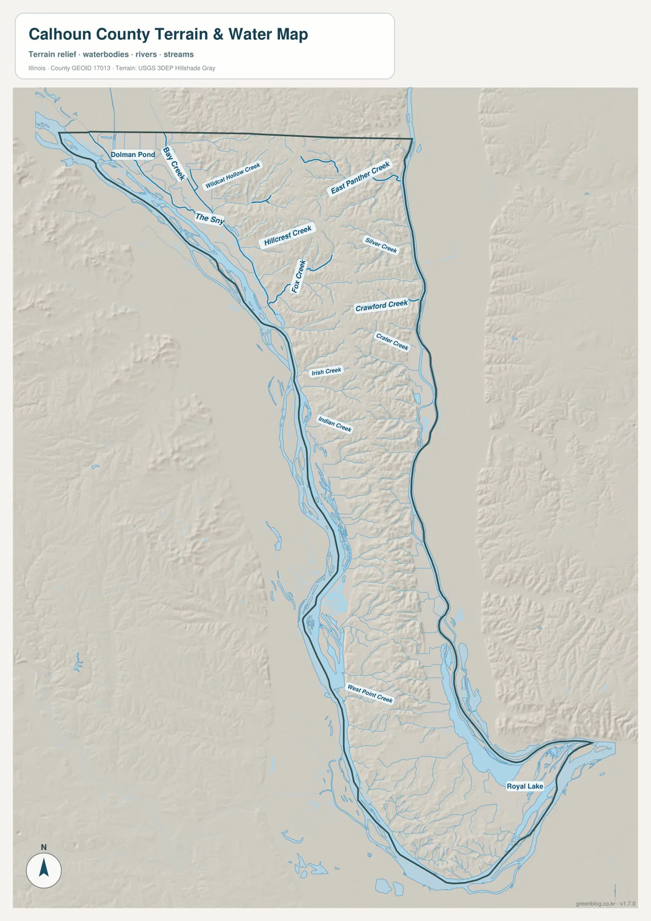
The county’s official visitor information describes communities nestled along the Mississippi and Illinois rivers. Farther south, the U.S. Fish and Wildlife Service operates Two Rivers National Wildlife Refuge from a headquarters in Brussels, where large-river and wetland habitats are part of the local landscape. Those official references fit what the map shows: the southern end around Brussels and Royal Lake is lower, broader, and more water-rich than the dissected central ridge.
The water map does not provide flood or navigation status
This map is a geographic reference for creeks, river-side channels, lakes, ponds, and terrain. It does not provide flood-hazard zones, live river stages, depth, ferry or boating status, levee condition, water rights, or legal access. Use current USGS, U.S. Fish and Wildlife Service, transportation, and local agency information for safety or regulatory decisions.
Low river margins frame a high central spine
The elevation map almost summarizes Calhoun County by itself. Dark green lowlands form long strips along both the western and eastern river margins. Between them, yellow, orange, and brown high ground runs north-south through the center. That central zone is not a smooth plateau; dozens of green creek valleys cut into it from both sides, creating the deeply dissected relief visible on the terrain map.
The map reports an actual countywide elevation range of about 128 to 247 meters and a mean of about 169 meters. Its color legend uses bands from roughly 128 to 231 meters, while the separate “Actual” line records the wider minimum and maximum in the underlying county dataset. Those endpoints describe Calhoun County as a whole; they are not exact elevations for Hardin, Brussels, Kampsville, or any specific road or property.
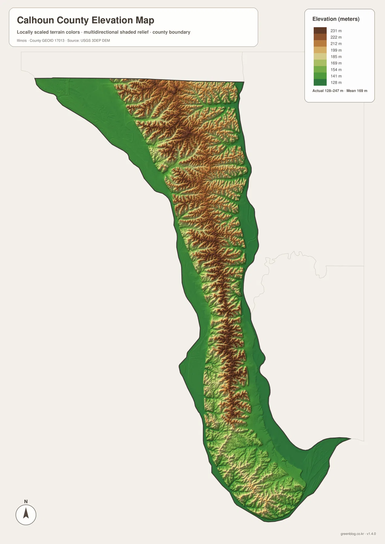
Comparing the elevation and water maps makes the drainage pattern intuitive. Bay Creek and Indian Creek descend through lower corridors toward the western side, while East Panther Creek and Crawford Creek drop toward the east. Around Brussels, the central ridge weakens and broader low terrain appears beside Royal Lake and major river channels. Few Illinois county maps show the relationship between county shape, rivers, and ridge topography as directly as this one.
128 to 247 meters is a countywide range
Do not assign the low or high endpoint directly to a named town. Exact elevation for a building site, levee, road grade, drainage design, or parcel requires location-specific source data or a professional survey. The elevation map is intended for broad county comparison rather than engineering measurement.
Choosing the right map for Calhoun County’s unusual geography
Use the county overview when you need Kampsville, Hardin, Hamburg, Batchtown, Brussels, Routes 96 and 100, boundaries, and streams together. The ranked-city map is better for quickly comparing the five labeled communities without road detail. Choose the terrain-and-water map for The Sny, Royal Lake, and the many short creeks descending from the central uplands. The elevation map is the clearest way to see the low river margins and the high interior ridge between them.
A practical sequence is to begin at Hardin on the overview, then trace the county north toward Kampsville and south toward Batchtown and Brussels while noting Hamburg on the western side. Next, simplify that settlement pattern with the city map. Move to the water map to compare west-flowing and east-flowing creeks, then finish with elevation to see why those streams occupy short valleys dropping away from a central spine.
Each map has a defined purpose. The overview is not a live-traffic, ferry-status, or parcel product, the CITY INDEX is not presented as a current census table, the water map does not assess flood or navigation conditions, and the elevation surface is not survey-grade. Within those limits, the set works well for printed reference sheets, teaching, presentations, county orientation, and trip-planning context.
Frequently Asked Questions
Why is Calhoun County so long and narrow?
The supplied maps and the county’s official description place Calhoun County between the Mississippi and Illinois rivers. Those two major river corridors form long western and eastern boundaries, leaving a narrow interior ridge and producing the county’s unusual north-south shape.
Are the CITY INDEX values current population counts?
This page does not treat them as current population figures because the supplied map does not display a census year or statistical date beside the index. Use a dated U.S. Census Bureau source when an official current population figure is required.
Does 128 to 247 meters give Hardin’s elevation?
No. The elevation map identifies 128–247 m as the actual range across the Calhoun County dataset and gives a mean of about 169 m. Exact elevation for Hardin or any specific road, property, levee, or structure requires point-specific elevation or survey data.
Sources and Reference Material
The article uses the supplied Calhoun County maps together with the official references below. For current ferry or road conditions, water information, legal boundaries, or exact point elevations, use the responsible agency’s current source data rather than these explanatory county maps.
- Calhoun County Official Website – county geography, communities, and visitor information
- Illinois State Archives – Calhoun County – establishment, name origin, and Hardin county-seat information
- U.S. Fish & Wildlife Service – Two Rivers National Wildlife Refuge – Brussels-area river and wetland context
- USGS National Hydrography – rivers, streams, lakes, and related hydrography data
- USGS 3D Elevation Program – elevation and terrain data
Map File Information
The high-resolution JPG originals for the Calhoun County overview, ranked-city map, terrain-and-water map, and elevation map are bundled in one ZIP file. Each image is 2,572 × 3,638 pixels, which suits the county's long vertical shape and provides more detail for zooming, printed reference sheets, classroom materials, and presentation graphics.
- Included Files: 4 high-resolution JPG maps
- Printable Size: 2,572 × 3,638 pixels each
Related Maps
Green Map creates custom-edited map images using open geographic data sources such as geoBoundaries, Natural Earth, OpenStreetMap, and government open data.
These maps are edited visual materials, not raw data files, and are provided for education, documents, presentations, and graphic reference.