Bradley County sits in southern Arkansas, where Warren is the clearest settlement and road hub while Banks and Hermitage provide useful reference points farther west and toward the middle of the county. The maps on this page are designed for readers who want to see those places in relation to county boundaries, creeks, small lakes, and local relief rather than looking at a single road layer alone. High-resolution JPG versions of the same supplied maps are available together in the ZIP download box near the end of the page.
The county has a noticeably different visual character from north to south. Warren and the main labeled routes are concentrated in the northern half, while much of the southern half contains long stretches of smaller roads and a dense network of streams. The elevation surface adds another layer: narrow ridges become more obvious across the north and center, then the landscape drops into lower ground toward the southern edge. Starting with Warren and following the maps southward makes these changes easy to connect.
Table of Contents
Warren anchors the road network while Banks and Hermitage spread the map west and south
On the general county map, Warren stands out in the northeastern part of Bradley County. Several routes meet around the city, and Arkansas Highway 4 runs west toward Banks. Around Banks, the map also labels routes 275 and 278, helping separate the small western community from the larger Warren road cluster. Hermitage lies farther south and closer to the middle of the county, near the junction of routes 15 and 160. Those three places create a practical framework for reading the rest of the map.
South of Hermitage, settlement labels become sparse and the shape of the county becomes more important. Route 189 bends across the southeastern interior, route 8 appears along the eastern side, and routes 63 and 600 are labeled near the southwest. The roads are less tightly grouped than they are around Warren, so the lower half of the map feels broader and more rural. This is also where the many light-blue stream lines become a useful background for understanding why routes do not form a simple grid.
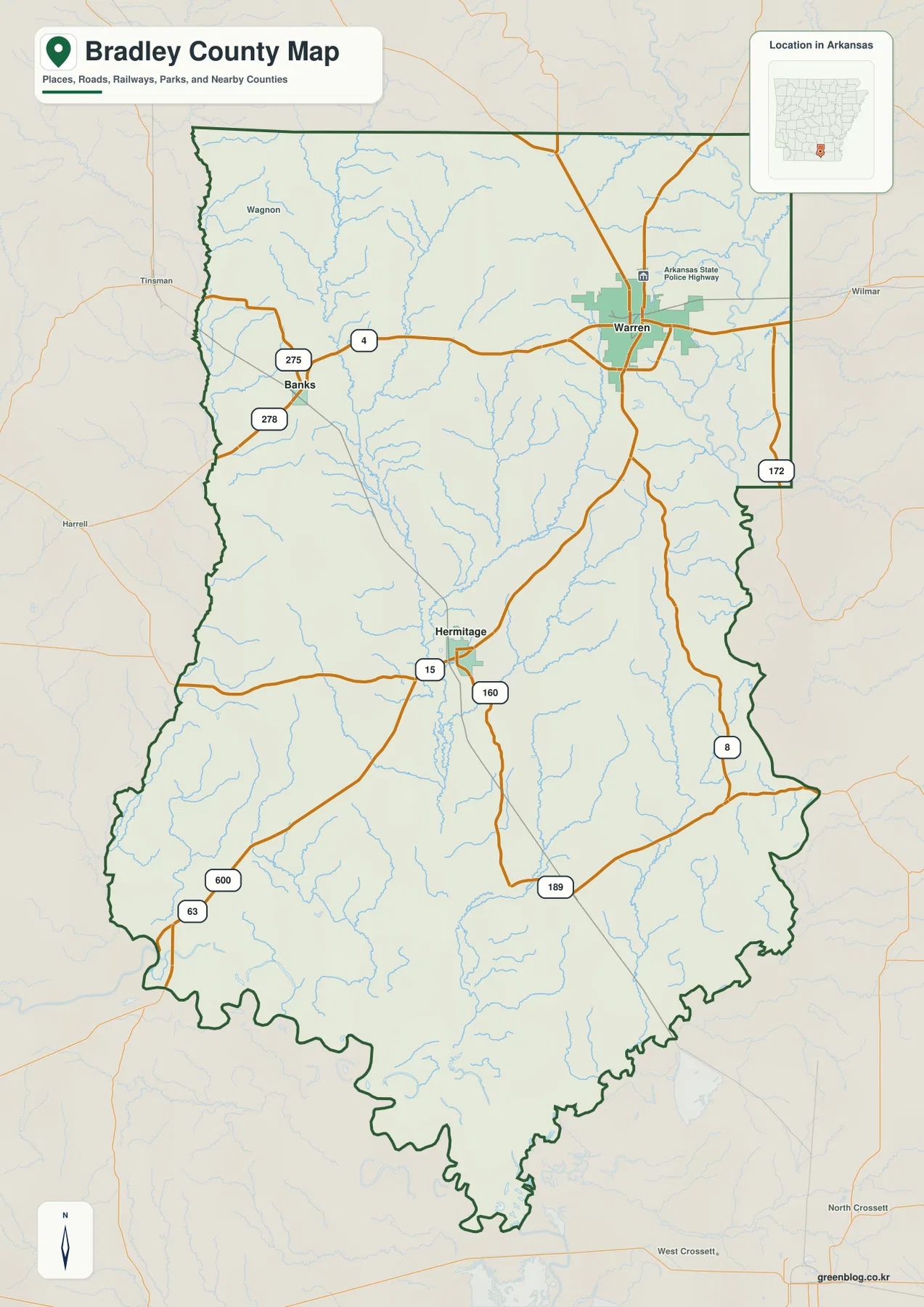
Use this map when the first question is “where is it?” rather than “how high is it?” or “which creek runs here?” It keeps the three principal labeled communities, the route numbers, and the county outline on one page. The map is not intended as live navigation, so road closures, turn-by-turn directions, and current travel times should be checked with a current transportation or navigation source. Its strength is orientation: it shows how the northern road hub relates to the much larger southern interior.
The city-connections view shows two equal straight-line distances from Warren
The city map reduces the number of labels and makes Warren the hub. Banks is shown about 12 miles from Warren by direct distance, and Hermitage is also shown about 12 miles away. These are straight-line distances between the mapped city points, not driving mileage. The symmetry is useful because it shows that the two smaller communities are similarly distant from Warren even though they lie in different directions: Banks is to the west, while Hermitage is southwest and closer to the county’s center.
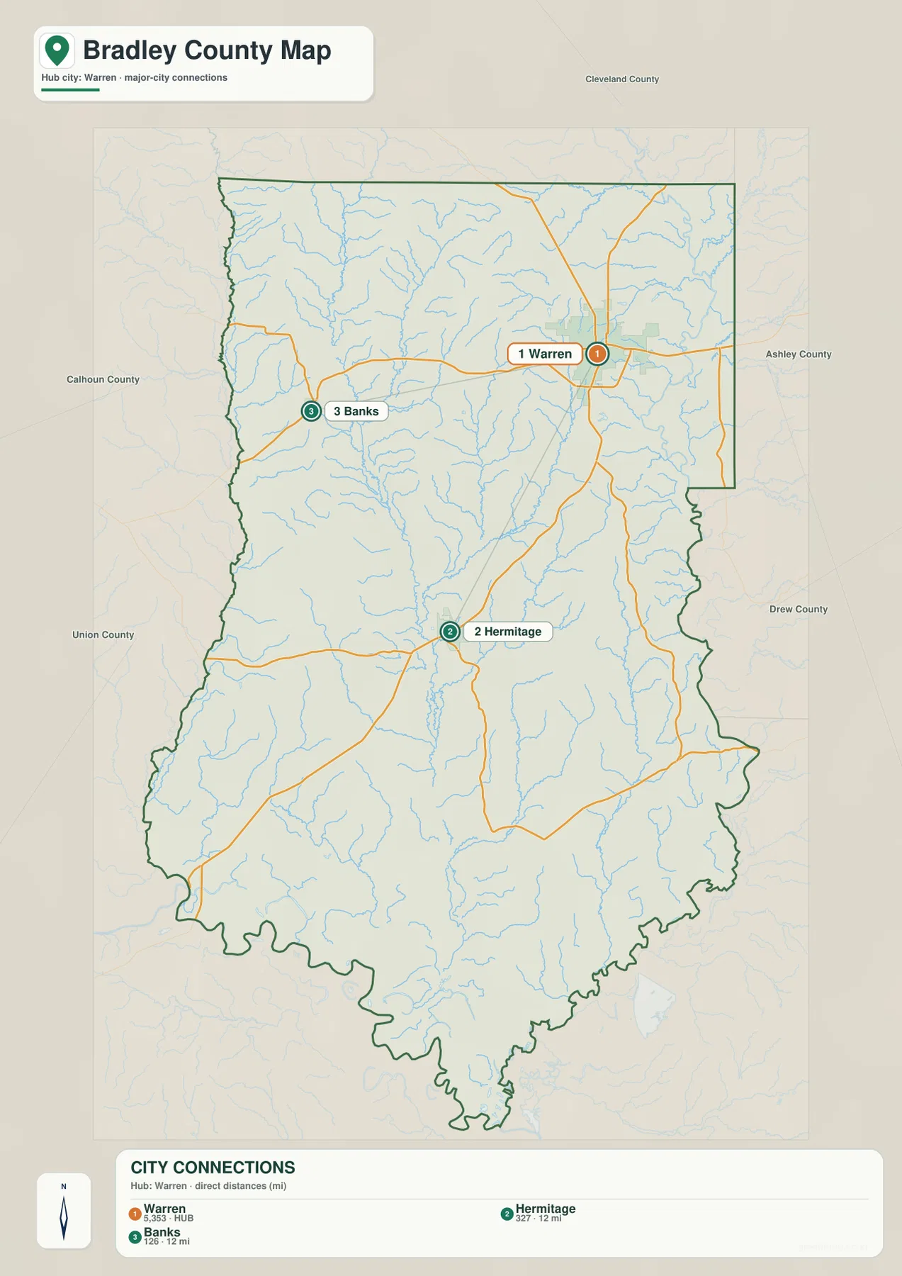
The surrounding county names add helpful context. Cleveland County is labeled to the north, Ashley County to the east, Drew County to the southeast, Union County to the southwest, and Calhoun County to the west. That border context makes the map more useful than a simple three-dot diagram. A reader can see why travel from Warren toward the east reaches a different neighboring county than travel south from Hermitage or west from Banks.
Warren is also the county seat, a fact documented in Arkansas reference sources and reflected visually by its larger road and built-up footprint on the general map. The city-connections map should not be used as a population chart, because its main purpose is location and distance. For current population figures or demographic comparisons, the Census should be used directly. For understanding where the county’s three incorporated communities sit relative to one another, this simplified view is the fastest map in the set.
L’Aigle Creek is the clearest thread through a branching water network
The water map changes the emphasis completely. L’Aigle Creek runs through the central part of Bradley County and continues south, with numerous smaller channels approaching it from both sides. Beach Creek and Charivari Creek are labeled in the western half, while Grassy Pond Creek appears east of the central channel. Snake Creek forms another strong north-south feature in the southeastern part of the county. The result is a map dominated by branching creeks rather than by a single large river or reservoir.
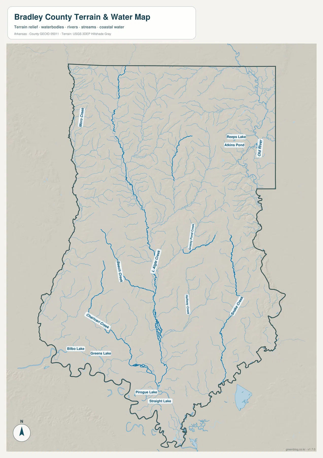
Several smaller water bodies help distinguish different corners of the county. Reeps Lake and Atkins Pond are labeled in the northeast, with Old River near the eastern side. Bilbo Lake and Greens Lake sit near the southwest, while Pirogue Lake and Straight Lake are labeled close to the southern edge. Moro Creek appears along the west side. These named features make the water map particularly useful when a location is easier to identify by a creek or lake than by a town.
This is a reference map of visible hydrographic features, not a flood-risk or navigation product. It does not indicate flood insurance zones, water depth, navigability, real-time stream stage, or parcel boundaries. If a project depends on any of those questions, use the appropriate official flood, water-management, or survey source. For ordinary geographic reading, however, the map makes one important point clear: Bradley County’s southern interior is crossed by far more water lines than the general road map alone suggests.
A 19–93 m elevation range reveals low southern ground and narrow interior ridges
The elevation map reports an actual range of about 19 to 93 meters and a mean elevation of about 48 meters. Bradley County is therefore not a high mountain landscape, yet the shaded surface is far from flat. Brown and tan ridges run through much of the northern and central interior, separated by lower green corridors. Toward the southern edge, darker greens cover a broader area, matching the lower ground associated with the county’s creek-rich bottomlands and valleys.
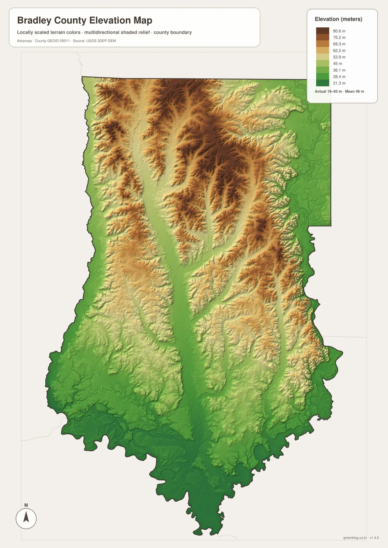
The best way to use the relief map is beside the water map. After locating L’Aigle Creek, Beach Creek, or Snake Creek, look at the elevation surface for the adjacent green valleys and the higher ridges between drainage lines. This comparison gives a much clearer sense of terrain than either layer provides on its own. It also explains why the county can look gently rolling even though the total elevation range is modest.
The shaded elevation surface is generalized for county-scale viewing. It is suitable for comparing higher and lower parts of Bradley County, but it is not a substitute for a site survey, engineering-grade elevation model, or construction plan. A single pixel or color band should not be treated as a precise property elevation. The useful information here is the broad contrast: higher narrow ridges in the north and center, lower valleys along stream corridors, and a larger low-lying area toward the south.
Following one place across the maps makes Bradley County easier to understand
Warren works well as the first anchor. On the county map, it is the main road concentration. On the city-connections map, it becomes the hub used to compare Banks and Hermitage. Move south from Warren toward Hermitage and then switch to the water map: the dense creek network becomes increasingly important. Finally, the elevation map shows how those water corridors occupy lower ground between narrow ridges. Reading the same part of the county four times is more informative than treating each map as a separate picture.
Banks offers a different example. The general map places it west of Warren near Highway 4 and routes 275 and 278. The city view gives the approximate 12-mile straight-line relationship to Warren, while the water map brings Moro Creek and western tributaries into view. The elevation surface then shows a mixture of lower channels and gently higher ground rather than the broad lowland seen at the far south. This sequence is useful for classroom work, trip context, local-history writing, or any project that needs a clear geographic frame before adding more detailed data.
Hermitage is a convenient midpoint for reading the county from north to south. It sits near routes 15 and 160, south of the main Warren road cluster but well north of the lowest southern edge. From Hermitage, the general map can be used to follow roads, the water map to trace nearby tributaries, and the elevation map to compare the surrounding ridges and valleys. For printed reports, choose the map that best matches the main question and use one or two of the others only when they add a different kind of information.
The ZIP below contains the high-resolution JPG originals for the general county map, city-connections map, water/terrain map, and elevation map used on this page. Each file is 2572 × 3638 pixels, suitable for A3-oriented printing when you need cleaner labels and linework than a browser screenshot can provide.
Frequently Asked Questions
Are the 12-mile Warren–Banks and Warren–Hermitage labels driving distances?
No. The city-connections map uses direct, straight-line distance between the mapped city points. Roads curve and may require a different route, so actual driving mileage and travel time will not match the 12-mile labels exactly. Use the city map to compare relative position, then check a current navigation source for a real trip.
Which map is best for locating L’Aigle Creek and the small lakes near the county edges?
Use the water map. It gives L’Aigle Creek a strong central line and also labels features such as Moro Creek, Beach Creek, Charivari Creek, Grassy Pond Creek, Snake Creek, Reeps Lake, Atkins Pond, Bilbo Lake, Greens Lake, Pirogue Lake, and Straight Lake. The general county map is better for roads and towns, but the water map is much easier when the feature you are trying to find is a creek, pond, or lake.
Can the 19–93 m elevation map be used for surveying or engineering design?
No. The map is a county-scale visualization that helps compare relative high and low ground. Its legend reports an actual range of roughly 19–93 meters and a mean near 48 meters, but the shaded surface is generalized. Property surveys, drainage design, road grading, and construction work require appropriate engineering or survey-grade elevation data.
Map File Information
The ZIP contains high-resolution JPG originals for the Bradley County general map, city map, water map, and elevation map.
- Included Files: county map, city map, water map, elevation map
- Printable Size: 2572 × 3638 px each
- File Type: JPG
Related Maps
Sources and reference data
County background and the county-seat context were checked against Arkansas reference material, while the boundary, hydrography, and elevation layers correspond to established federal geographic data programs. These links are useful when you need source data or more detailed local background.
- Encyclopedia of Arkansas – Bradley County – county background and Warren county-seat context
- U.S. Census Bureau TIGER/Line Shapefiles – county boundaries and base geography
- USGS National Hydrography – streams, lakes, and other hydrographic reference data
- USGS 3D Elevation Program – elevation and terrain reference data
The maps on this page are explanatory geographic graphics for orientation, printing, education, and general reference. They do not replace legal boundary records, live road information, flood-hazard mapping, land surveys, or engineering plans.
Green Map creates custom-edited map images using open geographic data sources such as geoBoundaries, Natural Earth, OpenStreetMap, and government open data.
These maps are edited visual materials, not raw data files, and are provided for education, documents, presentations, and graphic reference.