The Dixie County Map becomes much easier to understand once Cross City is used as the inland reference and the Gulf communities are treated as separate road endpoints. Cross City is the county seat on the US 19/98 corridor, while Horseshoe Beach lies southwest at the end of its own coastal approach. Suwannee is farther southeast near the lower Suwannee River and estuary, and the river itself forms much of the county’s eastern and southeastern boundary. This page uses only the three maps supplied in the package: the county reference map, the city map, and the terrain-and-water map. Download the high-resolution A3 JPG map ZIP from the file box below when you need the full-size versions of all three maps.
Table of Contents
Cross City Is the Inland Reference for Separate Trips to the Gulf
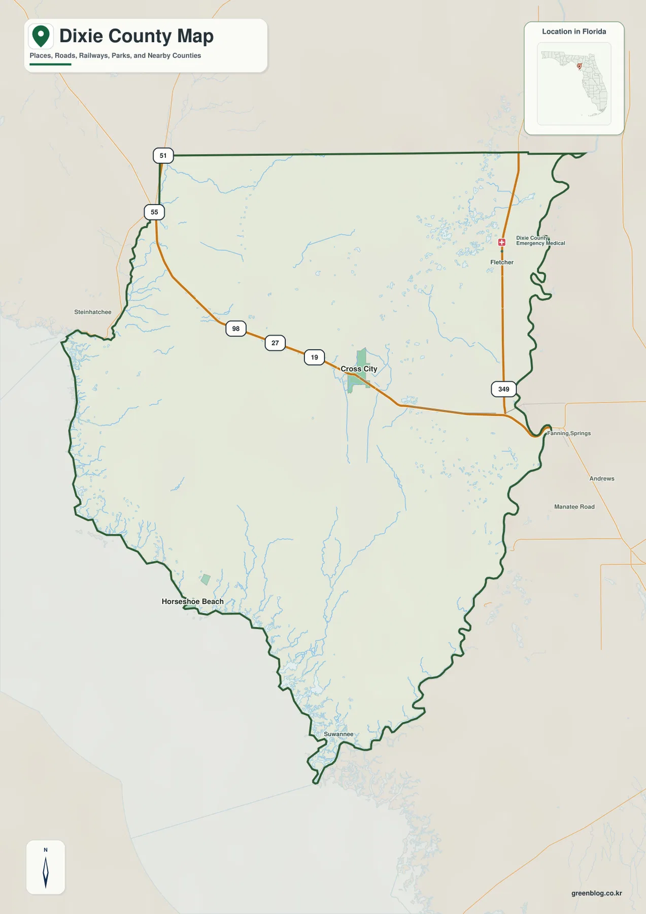
The general county map places Cross City near the center of the county along US 19/98. That route enters from the Taylor County side, passes the county-seat area, and continues southeast toward Old Town and Levy County. Because the main coastal approaches branch away from this inland corridor, Cross City is the most useful starting point for understanding the county’s road geography even though the most distinctive natural features lie closer to the Gulf and the Suwannee River.
Steinhatchee and Jena appear near the northwestern river edge, while Fletcher and Fanning Springs provide references along the eastern side. Horseshoe Beach is clearly separated on the southwest coast and Suwannee appears close to the southern tip. The large spaces between those labels are not simply empty parts of the map. Much of Dixie County is forest, wetland, refuge land, or sparsely settled rural country rather than a continuous suburban network.
The Census figures supplied with the package reinforce that impression. The 2020 Census counted 16,759 residents, while the July 1, 2025 estimate is 18,038. The same source gives 705.03 square miles of land and a 2020 density of 23.8 people per square mile. That combination produces a compact county-seat center, small communities at junctions or waterfront endpoints, and broad natural areas between them.
Horseshoe Beach and Suwannee Use Different Inland Approaches
Horseshoe Beach is reached from the Cross City side by County Road 351, which runs southwest toward the Gulf. Suwannee follows a different route from the Old Town side, using County Road 349 toward the lower river and estuary. The two places look relatively close on a small county map, but there is no simple public shoreline road joining them. Marshes, tidal creeks, and shallow coastal water separate the road endpoints.
The Old Town area also contains an important route-number distinction. The existing package explains that State Road 349 runs north of US 19/98 toward Lafayette County, while County Road 349 runs south toward Suwannee. The number stays the same, but the prefix and destination change. For a worksheet or annotated map, keeping “SR” and “CR” beside the number prevents the impression that one state-maintained route simply continues all the way to the estuary.
Shired Island is approached by County Road 357, adding another independent coastal branch between the Horseshoe Beach and Suwannee areas. This pattern is one of the most county-specific features on the map. The Gulf settlements should not be read as stops along one coastal strip; each one is connected back to the inland road system through a separate approach across wet lowlands.
The City Map Shows a Large Size Difference Between Cross City and Horseshoe Beach
The city map removes most secondary place names and highlights Cross City and Horseshoe Beach. Its CITY INDEX lists Cross City at 1,955 and Horseshoe Beach at 78, making the population difference visually obvious. Cross City is inland near the county’s main highway corridor, while Horseshoe Beach sits at the southwestern coast. The two incorporated municipalities are therefore separated by a broad rural and wetland landscape rather than joined by a continuous urban corridor.
The existing package identifies Cross City as the county seat and Horseshoe Beach as the other incorporated municipality. Old Town, Suwannee, Jena, and Shamrock are listed as unincorporated communities. Those places remain important for orientation on the general map, but the simplified city map is designed to show the municipal pattern, which is why only Cross City and Horseshoe Beach receive ranked city markers.
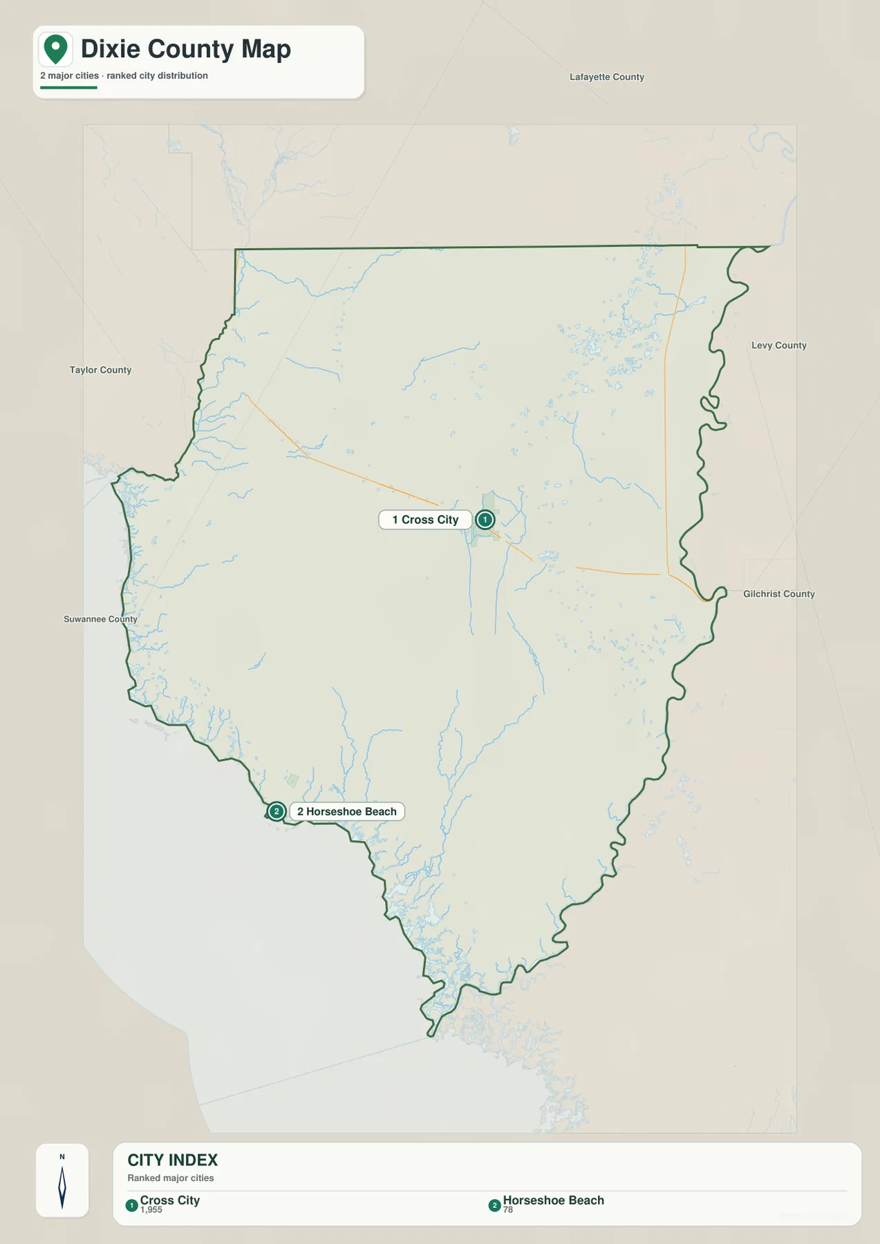
This simplified view is useful when the question is administrative rather than geographic. If a reader needs Old Town, Suwannee, Jena, road numbers, or river boundaries, the county map provides the better context. If the task is simply to show the two incorporated municipalities and their relative positions, the city map is clearer because it removes the extra local labels.
The Steinhatchee and Suwannee Rivers Define Different County Edges
At the northwest edge, the Steinhatchee River provides a natural reference between Dixie and Taylor counties. Jena lies on the Dixie County side, facing the community of Steinhatchee across the river. These two nearby place names can be confusing without the county line, so tracing the river first makes the boundary much easier to understand.
The Suwannee River creates a much longer natural boundary along the east and southeast. On the general map it bends south past the Fanning Springs area and continues toward the estuary. The community of Suwannee lies near the lower river and delta, which gives it a completely different water setting from Horseshoe Beach even though both are Gulf-side destinations.
The Lower Suwannee National Wildlife Refuge spans the lower river and estuary across Dixie and Levy counties. The U.S. Fish and Wildlife Service material supplied in the package describes a landscape where freshwater and saltwater meet through river channels, marshes, tidal creeks, and forest. This context explains why the southern county contains large areas with few road or settlement labels.
The Water Map Reveals Creeks and Ponds Hidden by the Road View
The terrain-and-water map adds names to many features that are easy to overlook on the county road map. Eightmile Creek appears in the northwest. Mathis Lake, Cow Pond, and Governor Hill Lake are labeled in the northeastern interior, while Ocean Pond and Long Pond sit farther south. North Canal is also shown through the central-eastern part of the county. These features demonstrate that the interior contains many small wetlands and water bodies in addition to the two large boundary rivers.
Closer to the Gulf, the map labels Fishbone Creek, California Creek, Sanders Creek, and Manson Creek. At the southern end, East Pass and Mitchell Creek appear within an increasingly complex marsh-and-channel landscape. The shoreline is therefore not a single clean boundary between land and open water. Tidal creeks and low marsh penetrate inland, which is why road access to the coast is concentrated on a few separate branches.
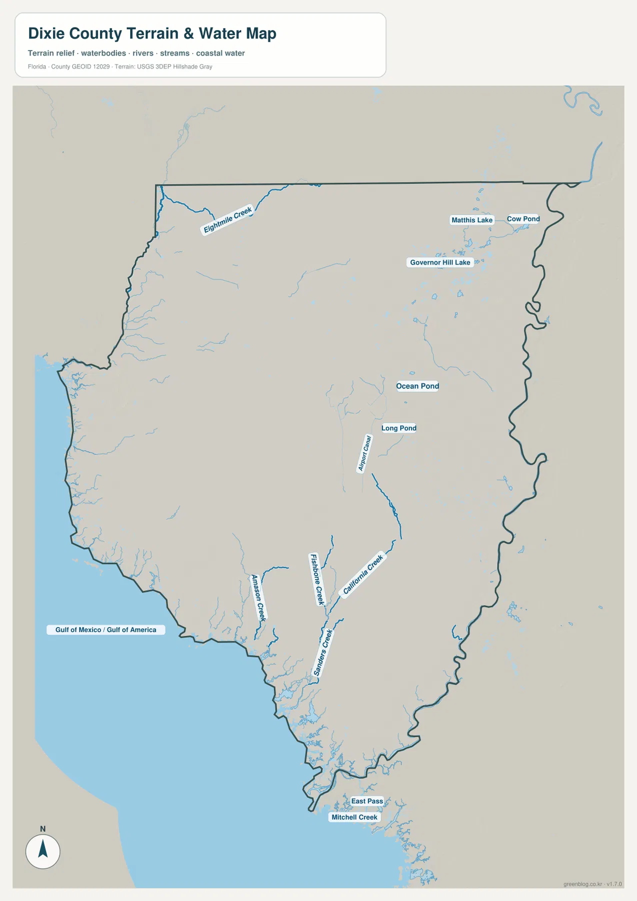
Florida FWC material in the package places part of the Big Bend Wildlife Management Area along the Dixie and Taylor Gulf coast north of Horseshoe Beach. Together with the Lower Suwannee refuge, that managed landscape helps explain the sparsely roaded shore. The coast is closer to a Nature Coast marsh-and-estuary environment than to a long, continuously developed sandy beachfront.
Old Town Is a Useful Reference for the 349 Route Change and the Nature Coast State Trail
Old Town is not an incorporated city, but it has an outsized role in county orientation. Traveling southeast from Cross City on US 19/98 brings a reader toward the place where SR 349 heads north and CR 349 heads south toward Suwannee. That makes Old Town a useful road-number reference even though it is not the county seat.
The Florida State Parks source included in the package also places the Nature Coast State Trail through the Old Town area toward Fanning Springs. The former rail corridor provides a second kind of connection across the county, distinct from the highway network. Reading the trail, US 19/98, and the Suwannee River together helps explain why Old Town matters more geographically than its municipal status alone would suggest.
Frequently Asked Questions
Are SR 349 and CR 349 the same road?
No. North of U.S. 19/98 near Old Town, SR 349 is a state route leading toward Lafayette County. South of the corridor, CR 349 is a county road leading toward Suwannee and the lower river. Writing only “349” can point a reader in the opposite direction, so the route prefix and destination are essential.
Can drivers follow the shoreline directly from Horseshoe Beach to Suwannee?
No continuous public shoreline road connects them. A driver leaves Horseshoe Beach on CR 351, returns to the U.S. 19/98 corridor, and then turns south from the Old Town area on CR 349 to reach Suwannee. Shired Island is a third independent endpoint on CR 357; marsh, tidal creeks, and managed land separate all three branches.
Can drivers follow one shoreline road from Horseshoe Beach to Suwannee?
No continuous public shoreline route is shown. Horseshoe Beach uses CR 351, while Suwannee is reached by CR 349 from the Old Town side. Broad marshes and tidal channels lie between the coastal endpoints, so actual driving routes return to the inland road system.
Why does the city map highlight only Cross City and Horseshoe Beach?
The package identifies Cross City and Horseshoe Beach as the incorporated municipalities. Old Town, Suwannee, Jena, and Shamrock are listed as unincorporated communities, so the simplified city map focuses on the two incorporated places.
Map File Information
Download the map files associated with this page for reference, printing, and compatible visual projects.
- Included Files: 3 high-resolution A3 JPG maps described on this page
- File Type: JPG files in a ZIP archive
- Intended Use: Printing, education, presentations, and map-based projects
Related Maps
- Arcadia Roads and Peace River | DeSoto County Florida Map
- Baker County Florida Map
- Blountstown, SR 20, and the Apalachicola River | Calhoun County Florida Map
Sources
- U.S. Census Bureau QuickFacts — Dixie County, Florida — population and land-area reference
- Official Dixie County website — county government and local information
- Florida Department of Transportation — County General Highway Maps — US 19/98 and major-road reference
- U.S. Fish & Wildlife Service — Lower Suwannee National Wildlife Refuge — lower-river and estuary wetland reference
- Florida FWC — Big Bend Wildlife Management Area — managed Gulf-coast landscape reference
- Florida State Parks — Nature Coast State Trail — Old Town and Fanning Springs corridor reference
Green Map creates custom-edited map images using open geographic data sources such as geoBoundaries, Natural Earth, OpenStreetMap, and government open data. These maps are edited visual materials, not raw data files, and are provided for education, documents, presentations, and graphic reference.