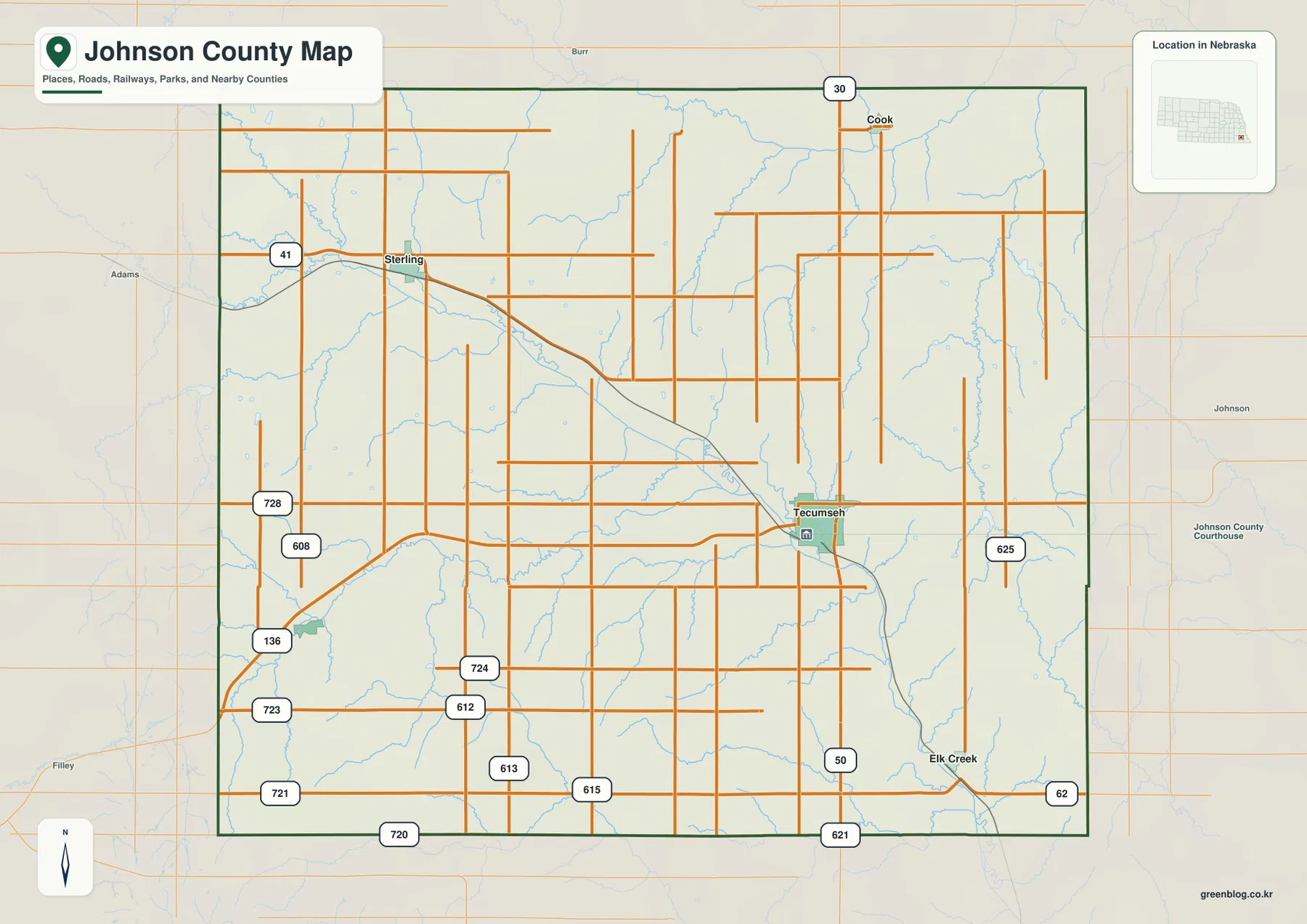
Johnson County occupies a compact part of southeastern Nebraska, with Tecumseh serving as the county seat and the main road reference. U.S. 136 reaches the city from the southwest, Nebraska Highway 50 runs north–south through the same area, and smaller communities such as Sterling, Cook, Elk Creek, and Crab Orchard are spread around the county. This page connects those roads and towns with the North Fork Big Nemaha River, smaller creeks, and an elevation range of roughly 304 to 454 meters. The four original high-resolution JPG maps can also be downloaded together in a ZIP file for printing or close inspection. High-resolution map files are available for download in the section below.
The county government lists Johnson County at 376 square miles and identifies Tecumseh as the county seat. Although the boundary looks fairly simple, the land inside it is crossed by a long northwest-to-southeast valley and dozens of short tributaries. The southwest is noticeably higher, while the east and northeast contain more low ground. Looking at settlement, water, and elevation together therefore gives a much clearer picture than treating the county as a flat block of farmland.
Table of Contents
Tecumseh turns U.S. 136 and Highway 50 into an easy county-wide reference
Tecumseh is the best place to begin on the general county map. U.S. 136 enters Johnson County from the southwest and reaches the city, while Nebraska Highway 50 approaches from the north and continues south toward Elk Creek. The City of Tecumseh also describes the community as lying at the intersection of U.S. 136 and Highway 50. With those two routes fixed in mind, the positions of Sterling to the northwest, Cook to the north, Elk Creek to the southeast, and Crab Orchard to the southwest become much easier to organize.
Sterling sits in the northwestern part of the county along Highway 41. Cook is near the northern boundary, where Highway 30 provides an east–west route. Elk Creek lies southeast of Tecumseh and close to Highway 50, with Highway 62 continuing toward the east. Crab Orchard is farther southwest and is best located by using U.S. 136 together with local roads. The communities do not form one straight settlement corridor, so Tecumseh works better as a central orientation point than any single highway line.
Gage, Otoe, Nemaha, and Pawnee counties provide the main surrounding frame, while Lancaster and Richardson counties are also labeled nearby on the broader map. The administrative boundary is relatively regular, but the roads and streams inside it are not. A broad valley runs diagonally across the county, breaking up the square road grid and creating a visible northwest–southeast direction. That contrast between straight boundaries and winding terrain is one of the reasons the map is easier to read when roads and waterways are considered together.
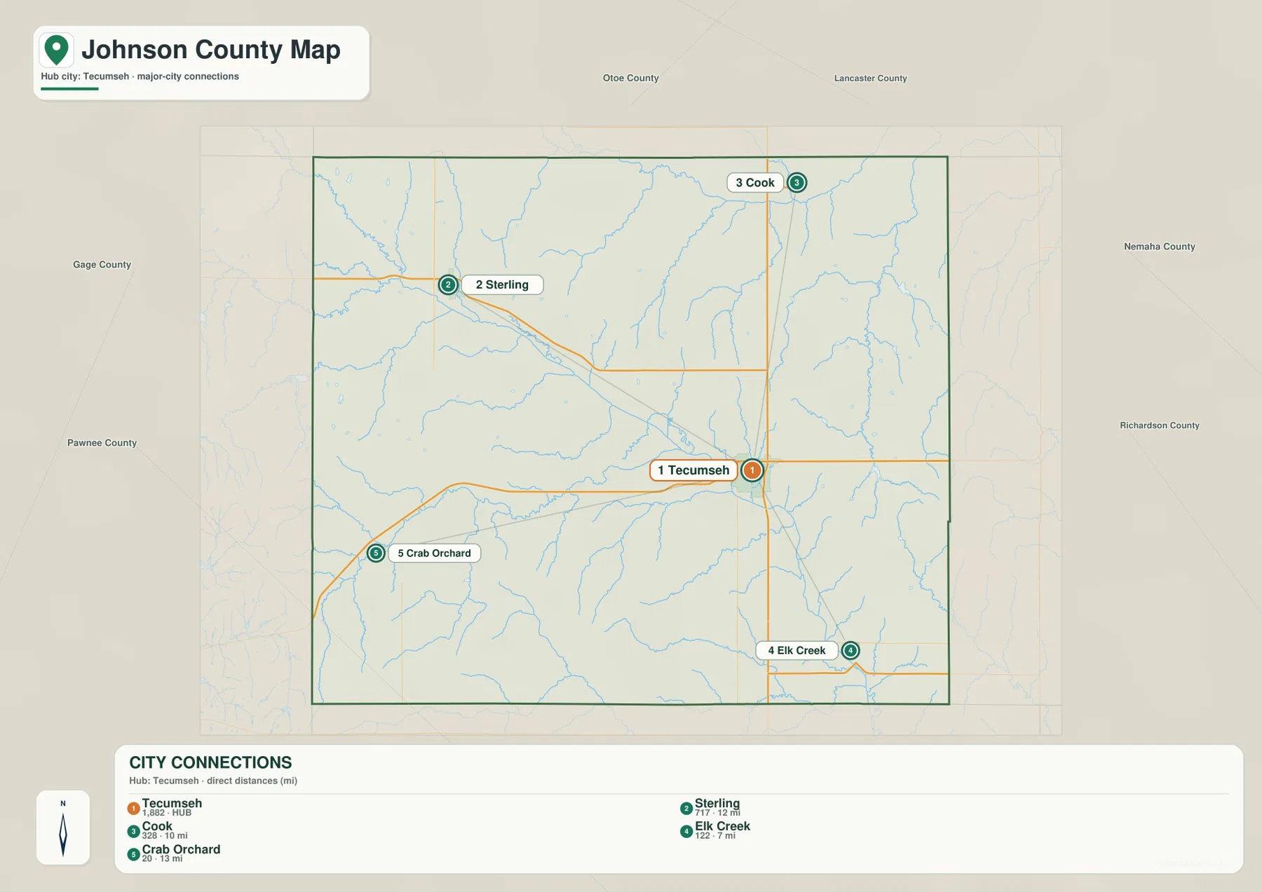
Straight-line connections show how Tecumseh relates to four smaller communities
The city-connections map uses Tecumseh as the hub and measures direct, straight-line distances to four other communities. Elk Creek is shown about 7 miles away, Cook about 10 miles, Sterling about 12 miles, and Crab Orchard about 13 miles from Tecumseh. These are not driving distances. Actual road travel follows the highway and local-road network, so the map is best used to compare relative proximity and direction rather than to estimate mileage for a trip.
The same graphic numbers Tecumseh first, Sterling second, Cook third, Elk Creek fourth, and Crab Orchard fifth. It also prints a city index value beside each place, but those figures should not be treated as a live population table. Johnson County’s official site provides a separate 2020 community summary, and current demographic questions should be checked against newer Census data when necessary. For geographic reading, the important point is that Tecumseh is the largest and most central labeled settlement while the others remain small communities around it.
The directional pattern is easy to remember once the hub is established. Sterling lies northwest of Tecumseh, Cook is north, Elk Creek is southeast, and Crab Orchard is southwest. Those four directions cover most of the county and help explain why Tecumseh functions so well as a reference point. The pattern also makes it clear why a direct-distance map and a road map serve different purposes: one simplifies the geometry between towns, while the other shows the actual routes that must cross or follow the local terrain.
The North Fork Big Nemaha River cuts the county along a broad diagonal valley
The North Fork Big Nemaha River is the strongest water feature on the terrain-and-water map. It enters from the northwest and runs diagonally through the central part of Johnson County before continuing toward the southeast. The elevation map traces the same route as a long green lowland, making the river valley easy to identify even without labels. Its course also helps explain why the landscape around Tecumseh does not follow the simple north–south and east–west geometry of the county boundary.
Several smaller streams join or approach the North Fork system. Hober Creek and Deer Creek are labeled to the west, while Beatty Creek and Yankee Creek occupy southern tributary valleys. Badger Branch and Cooper Branch appear south of Tecumseh, and Todd Creek runs across the lower part of the county. Once the main river is found, these smaller names make more sense because they can be read as individual valleys feeding into a larger drainage network rather than as isolated blue lines.
Northern Johnson County includes a separate set of waterways. The South Fork Little Nemaha River crosses the upper part of the map, with Silver Creek and Akeley Creek nearby. Farther east, Manns Branch and Spring Creek provide additional north–south drainage. These streams show that the county is divided among several local valleys rather than shaped by one river alone. The rolling uplands between them are especially visible when the water map is compared with shaded relief.
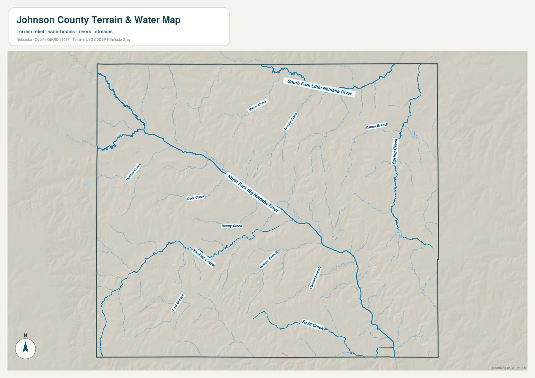
This is a general water-reference map, not a flood, parcel, boating, or real-time stream product. A creek shown on the page does not indicate current flow, bridge status, public access, or legal boundaries. Those questions require current information from the appropriate agency. Here, the value of the water layer is geographic: it shows how the named communities and roads fit around the major valley and the network of smaller tributaries.
Elevation falls about 150 meters from the higher southwest to the eastern lowlands
The supplied elevation map gives an actual county-wide range of about 304 to 454 meters, with a mean near 377 meters. The highest brown terrain occupies much of the southwest and parts of the west, while the east and northeast contain more green. A difference of roughly 150 meters is modest compared with mountain counties, but it is large enough to create clear ridges, tributary valleys, and a broad low corridor through the middle of Johnson County.
The North Fork Big Nemaha River valley is the most obvious low feature. A green band enters from the northwest, crosses the central part of the county, and continues southeast beyond Tecumseh. Short side valleys descend toward it from both sides, especially near the Sterling side and across the southern interior. The river map and elevation map line up closely here: blue channels occupy the same low corridors that appear green on the relief surface.
The southwestern quarter has a very different appearance. Brown and orange ridges are packed more closely together around the Crab Orchard side of the county, while Yankee Creek and Beatty Creek cut narrow lower paths through them. Moving eastward, the colors become greener, but the terrain never becomes completely smooth. Spring Creek and other tributaries continue to carve shallow valleys into the lower eastern surface.
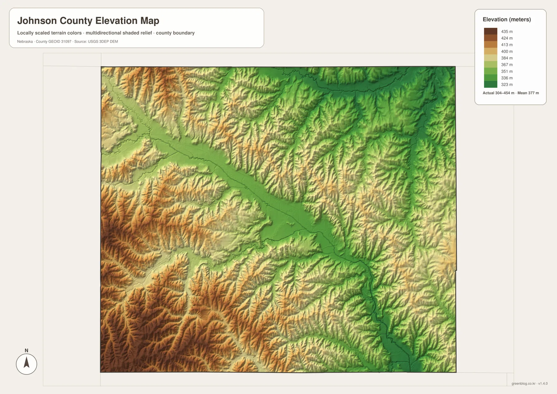
The elevation surface is generalized for county-scale comparison. It should not be used as survey-grade information for a parcel, building site, drainage design, road grade, or engineering project. Those tasks require current detailed elevation data such as the USGS 3D Elevation Program and, where appropriate, professional measurements. For regional study, however, the 304–454 meter range gives a clear picture of how strongly the river valleys separate the higher and lower parts of the county.
Tecumseh links county government, road travel, and the main river valley
Tecumseh’s role is historical as well as geographic. The city’s official history says the settlement was established in 1856 under the name Frances and was renamed Tecumseh soon afterward. The Nebraska Territorial Legislature designated Tecumseh as the Johnson County seat in February 1857. On the modern maps, the same place remains the easiest county-wide reference because government offices, U.S. 136, Highway 50, and the main Big Nemaha drainage all come together in the same general area.
Moving northwest from Tecumseh toward Sterling brings the road network closer to the upper part of the North Fork Big Nemaha valley. Cook, to the north, belongs to a different setting near the South Fork Little Nemaha system and northern tributaries. Elk Creek lies southeast along Highway 50, while Crab Orchard occupies higher country to the southwest. These differences help explain why the five communities look close together on a small county outline but occupy noticeably different terrain when the water and elevation layers are added.
Johnson County also fits into a wider southeastern Nebraska landscape. The nearby counties share rolling agricultural uplands and stream valleys, and neither roads nor rivers stop at the administrative line. That is especially clear where the Big Nemaha drainage continues beyond the map. Treating the county boundary as a location frame, rather than a physical barrier, makes it easier to understand how local terrain connects with the surrounding region.
Use the road map for places, the water map for valleys, and elevation for relief
The general county sheet is the most useful choice for locating Tecumseh, Sterling, Cook, Elk Creek, U.S. 136, and Highways 50, 41, 30, and 62. It keeps roads, communities, the boundary, and nearby county names in one view. The city-connections version simplifies the picture and is better when the question is how Tecumseh relates to Sterling, Cook, Elk Creek, and Crab Orchard. Remember that its mileage labels are straight-line distances rather than driving distances.
For physical geography, the terrain-and-water map provides the most useful named detail. It follows the North Fork Big Nemaha River while also identifying the South Fork Little Nemaha River, Spring Creek, Yankee Creek, Todd Creek, and other tributaries. The elevation map removes most place labels and emphasizes height instead, making the higher southwest and the lower central and eastern corridors easy to compare.
A practical study sequence is to locate Tecumseh and the highways first, trace the same area on the water map, and then check the elevation surface. The WebP images on the page are quick previews, while the original JPG files are better for enlarging labels or printing. These are general-reference maps, so legal boundaries, flood determinations, live road conditions, surveying, and engineering work should use the latest authoritative source for the specific task.
Frequently Asked Questions
Where is the Johnson County seat?
Tecumseh is the county seat. Johnson County’s official website and the City of Tecumseh both identify it as the county government center. On the map, it is also an effective geographic reference because U.S. 136 and Highway 50 meet there near the North Fork Big Nemaha River corridor.
Are the 7–13 mile labels on the city map driving distances?
No. The city-connections map uses direct straight-line distances from Tecumseh to Elk Creek, Cook, Sterling, and Crab Orchard. Actual driving mileage follows the road network and can be longer, so current navigation information should be used when planning a trip.
Can the 304–454 meter elevation range be used for surveying or construction?
No. The range is a generalized county-scale summary intended to compare the higher southwest with the lower river valleys and eastern terrain. Parcel surveys, construction, drainage design, and road engineering require current detailed elevation data and professional measurements rather than this regional map.
Map File Information
The county, city-connections, terrain-and-water, and elevation maps are available together in one ZIP file. It contains four original high-resolution JPG maps suitable for detailed viewing and printing.
- Included Files: County map, city-connections map, terrain-and-water map, elevation map
- File Type: JPG files in a ZIP archive
Related Maps
Sources and references
These official and public sources provide additional context for Johnson County government, Tecumseh history, administrative boundaries, waterways, and elevation. The maps on this page are simplified for readable regional reference, so legal, engineering, and current-condition decisions should be checked against the original authoritative datasets and notices.
- Johnson County, Nebraska official website – county seat, area, communities, and government information
- City of Tecumseh – History – settlement and county-seat history
- U.S. Census Bureau TIGER/Line – administrative boundary and geographic reference data
- USGS National Hydrography – river and stream data
- USGS 3D Elevation Program – elevation data
Green Map creates custom-edited map images using open geographic data sources such as geoBoundaries, Natural Earth, OpenStreetMap, and government open data. These maps are edited visual materials, not raw data files, and are provided for education, documents, presentations, and graphic reference.