Franklin County lies in east-central Missouri, where the Missouri River defines the northern edge and the Meramec and Bourbeuse river systems divide a broad landscape of towns, valleys, and rolling hills. Washington is the strongest northern city reference, Union sits near the middle of the county, and Pacific, St. Clair, Sullivan, and New Haven extend the settlement pattern east, south, southwest, and northwest. This page compares roads, ranked city distribution, waterways, and an elevation range of about 130 to 319 meters. High-resolution JPG versions of the same map themes are available together in a ZIP for printing, offline reference, or closer inspection. High-resolution map files are available for download in the section below.
Franklin County is part of the wider St. Louis metropolitan area, yet large rural stretches remain between its communities. The Missouri River follows the north, the Meramec occupies the eastern and southeastern side, and the Bourbeuse River winds through the interior. Washington and New Haven sit close to the northern river corridor, while Union is farther inland. Pacific is near the eastern edge, St. Clair lies to the south, and Sullivan sits near the southwest boundary. Moving between the road, water, and elevation layers makes those different settings much easier to understand.
Table of Contents
Washington and Union provide the clearest orientation
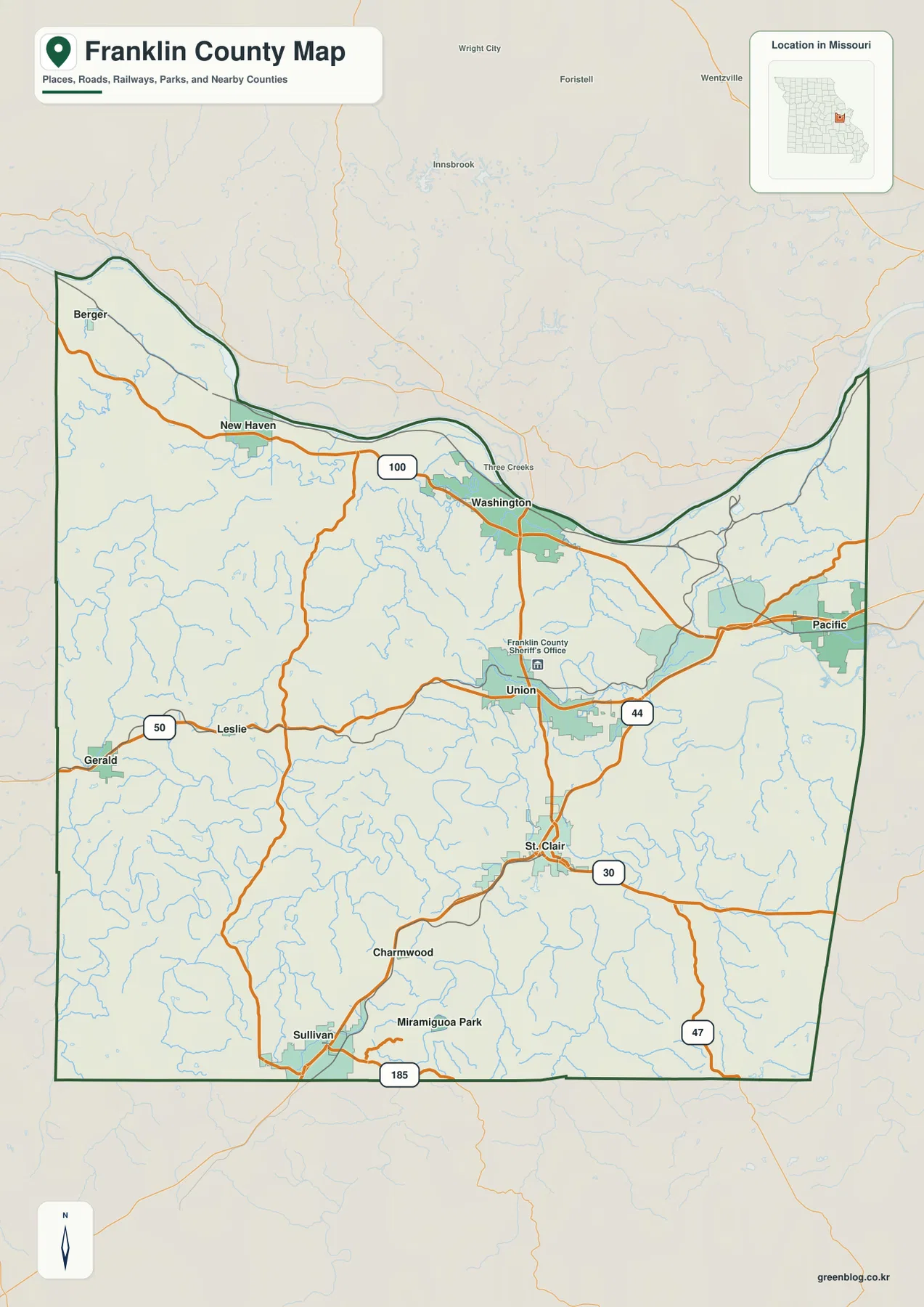
Washington is the most prominent city near the Missouri River on the general map. Route 100 passes through the area and continues west toward New Haven, giving the northern part of the county a strong east-west reference. Union lies farther south and east of Washington and is marked near the Franklin County Sheriff’s Office. Roads radiate from the Union area toward Washington, St. Clair, Pacific, and the western communities, so it works well as an inland anchor when reading the map.
Pacific occupies the eastern edge close to the St. Louis side of the county. St. Clair lies farther south, where Route 30 and Route 47 are useful reference lines. Sullivan sits near the southwestern boundary and connects with Route 185, while U.S. 50 appears by Gerald in the west. New Haven is positioned along the northern river corridor. The map is best used for county-scale orientation rather than live navigation, but it clearly shows how the major communities relate to the main road network.
Six ranked cities are spread across several parts of the county
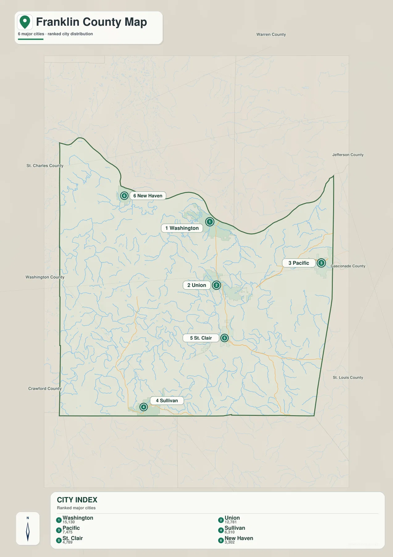
The ranked city map identifies Washington first, Union second, Pacific third, Sullivan fourth, St. Clair fifth, and New Haven sixth. These are ranking markers for the map, not measurements of driving distance or travel time. Washington and New Haven occupy the Missouri River side of the county, Union is inland near the center, Pacific is far to the east, and Sullivan and St. Clair anchor different parts of the southern half.
The distribution matters more than the ranking numbers. Franklin County does not form one continuous urban strip. Instead, several cities are separated by rural land, streams, and rolling hills. Washington serves the northern river corridor, Union connects the interior road network, Pacific sits near the eastern metropolitan edge, and Sullivan provides a southwestern reference. The city layer is therefore a quick way to see where the principal communities sit before returning to the general map for roads and smaller place labels.
The Missouri River forms the long northern boundary
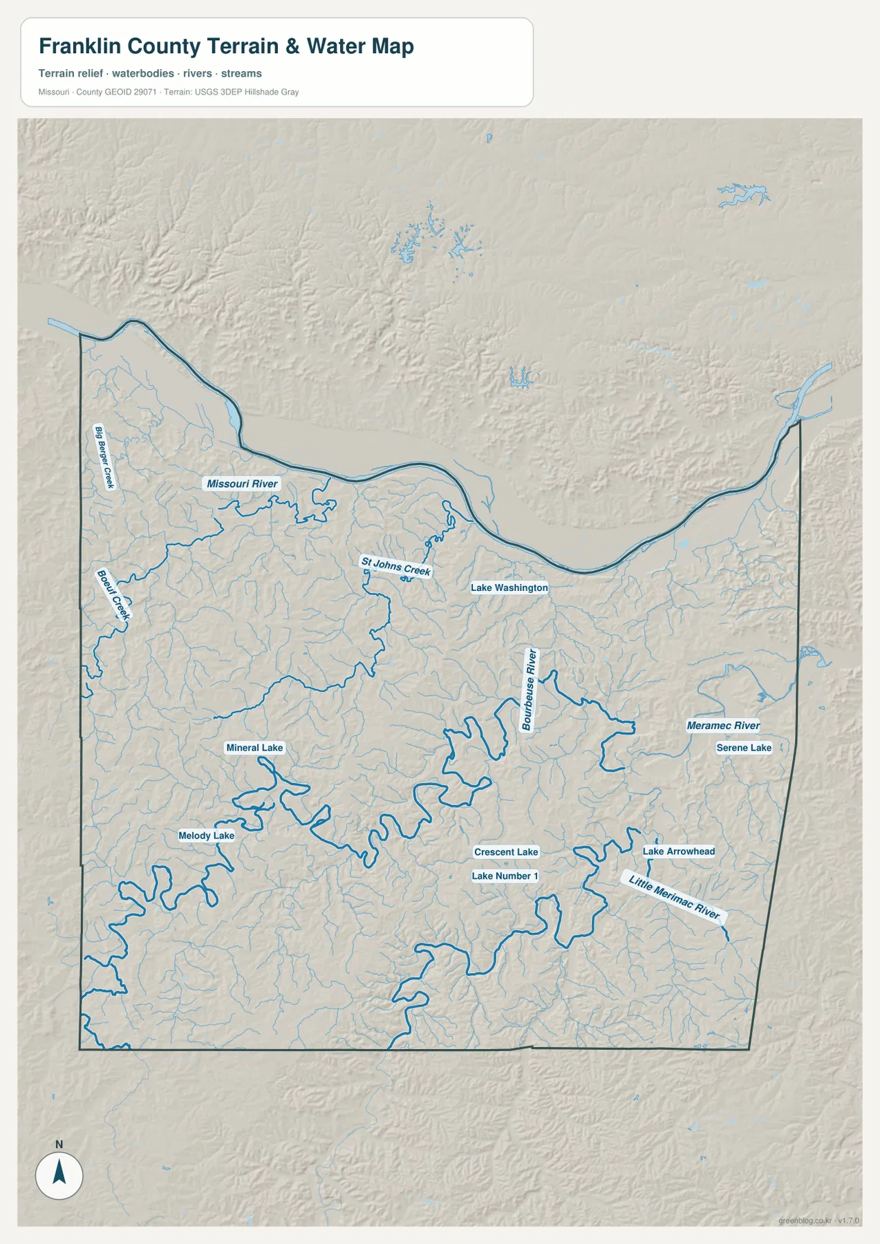
The Missouri River is the largest feature on the terrain-and-water map. It enters along the northwest, bends past the New Haven and Washington area, and continues east along the county’s northern edge. The same corridor appears in deep green on the elevation map, showing that the river occupies some of the lowest ground in Franklin County. Smaller tributaries descend from the interior hills toward the river, creating a detailed sequence of valleys immediately south of the floodplain.
St Johns Creek is labeled south of the Missouri River, while Big Berger Creek and Boeuf Creek appear farther west. These smaller streams help divide the northern uplands into separate ridges and valleys. Looking at Washington and New Haven across the water and elevation maps shows that both cities belong to the same broad northern river setting, but the shape of nearby tributaries and uplands differs from one location to the other.
The Bourbeuse River winds through the county interior
The Bourbeuse River is the dominant interior river on the water map. It follows a highly sinuous course through the central and eastern part of Franklin County, collecting many small tributaries before connecting with the larger Meramec system. The pronounced bends are easy to recognize and make the interior look very different from a flat, rectangular plain. Around Union and the surrounding rural areas, the river is one of the best natural reference lines.
Several smaller named water bodies appear near this part of the map. Crescent Lake and Lake Number 1 are close to the central-eastern area, while Mineral Lake and Melody Lake are farther west. Lake Arrowhead and Serene Lake appear on the eastern side. These lakes are not large enough to shape the entire county, but they are useful local landmarks when matching a particular area between the road, water, and elevation maps.
The Meramec and Little Meramec rivers shape the east and southeast
The Meramec River is the main river reference on the eastern and southeastern side of Franklin County. Its valley appears as a broad green lowland on the elevation layer, with higher hills rising away from the channel. The Little Meramec River is labeled separately farther south, showing how the Meramec drainage reaches deeply into the county. Pacific and St. Clair are useful city anchors for exploring this part of the map.
Missouri Department of Conservation identifies River ‘Round Conservation Area as a Franklin County site bordered by the Meramec River for 3.30 miles, with access from the St. Clair area. That county-specific public land provides a concrete real-world connection to the river shown on the map. The terrain-and-water layer is suitable for geographic reference, but anyone needing current river levels, flood warnings, or legal property boundaries should consult the appropriate official source.
Elevation ranges from about 130 to 319 meters
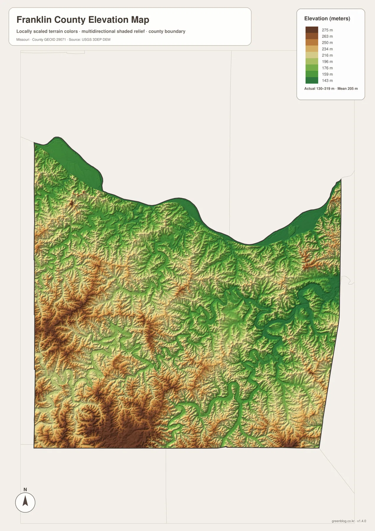
The elevation map reports an actual range of approximately 130 to 319 meters, with a mean near 205 meters. The lowest areas follow the Missouri River, Meramec River, Bourbeuse River, and some major tributary valleys. Higher terrain is much more extensive in the southwest and south, where tan, orange, and brown ridges fill large sections of the map. The difference is easy to see when the northern river corridor is compared with the hills west and south of Sullivan.
The county does not rise toward one single mountain. Instead, numerous ridges are separated by stream valleys, especially in the western and southern interior. The Missouri River lowland changes quickly into higher ground just to the south, while the Meramec and Bourbeuse valleys cut lower corridors through the eastern half. The elevation layer is useful for broad geographic comparison, but it is not a substitute for survey-grade elevations, engineering measurements, or parcel-specific topographic data.
Washington and New Haven are useful Missouri River comparisons
Washington and New Haven both sit near the northern Missouri River corridor, making them a useful pair for comparing the river, roads, and nearby relief. Route 100 helps connect the two locations on the general map. On the water layer, tributaries enter the larger river from the south. On the elevation map, the low floodplain appears green and is bordered by higher ridges only a short distance inland.
Franklin County’s official About page states that the county was established in 1818 after separation from St. Louis County and that the county seat was permanently moved to Union in 1825. It also describes Franklin County as part of the St. Louis metropolitan area with both rural and urban living. Those facts fit the map well: Washington is a major northern river city, while Union serves as the inland county-seat reference for a county that contains both developed communities and large rural spaces.
Union and St. Clair reveal the interior river-and-hill pattern
Union and St. Clair sit in the interior rather than directly on the Missouri River. Roads connect them, but the water layer shows that the space between and around the two cities is crossed by the Bourbeuse River and many smaller tributaries. The elevation layer adds the ridges between those channels. A simple north-south comparison on the road map therefore becomes much richer when the river and relief layers are added.
East of St. Clair, the Meramec system becomes more important, while southwest toward Sullivan the higher ridges occupy more of the map. From Union, the eastern route toward Pacific leads closer to the lower Meramec valley, while the western side transitions into broader uplands. These differences help explain why Franklin County contains both metropolitan-edge communities and more rugged rural country within the same boundary.
A practical way to use the map set
Start with one familiar city and trace it across the maps. Find Washington on the general map, move to the terrain-and-water layer to locate the Missouri River, and then check the elevation map to see the low river corridor. Repeat the same process with Union to compare roads, the Bourbeuse River, and nearby ridges. Pacific and St. Clair work well for examining the Meramec side of the county, while Sullivan highlights the higher southwestern terrain.
The downloadable ZIP contains high-resolution JPG versions of the general county map, ranked city distribution map, terrain-and-water map, and elevation map. The on-page WebP images are convenient for quick viewing, while the JPG files are better for enlarging labels, printing a reference sheet, or comparing layers side by side. The files are intended for geographic reference and do not replace live road information, emergency warnings, flood forecasts, or legal boundary surveys.
Official and public sources for Franklin County
Franklin County Government’s official website lists the Government Center in Union and provides current county department information. Its About Franklin County page describes the county’s 1818 formation, Union’s role as county seat, and the mix of suburban and rural land across the county. These pages are useful companions to the map because they connect Washington, Union, the Meramec River, and other visible features with current public information.
Missouri Department of Conservation provides additional county-specific context through River ‘Round Conservation Area and its broader Meramec River resources. Boundary and road information can be checked through U.S. Census Bureau TIGER/Line files, hydrography through USGS National Hydrography, and elevation through the USGS 3D Elevation Program. These sources are appropriate when more detail is needed than a general county reference map can provide.
Frequently Asked Questions
What are the easiest cities to use as references in Franklin County?
Washington and Union are the clearest starting points. Washington anchors the Missouri River side of the county, while Union provides an inland reference close to the central road network and Bourbeuse River country.
Do the numbers on the city map represent driving distance?
No. They rank six highlighted cities—Washington, Union, Pacific, Sullivan, St. Clair, and New Haven. The numbers are not mileage or travel-time measurements.
What elevation range is shown on the Franklin County map?
The elevation layer shows an actual range of about 130 to 319 meters, with a mean near 205 meters. Major river valleys are lower, while higher hills are widespread in the south and southwest.
Map File Information
Download the map files associated with this page for reference, printing, and compatible visual projects.
- Included Files: Use only the versions confirmed in the article and supplied images
- File Type: Use the confirmed download contents
- Intended Use: Printing, education, presentations, and map-based projects
Related Maps
Sources and references
- Franklin County Government – About Franklin County – county history, Union, and local context
- Franklin County Government – county departments and Government Center information
- Missouri Department of Conservation – River ‘Round Conservation Area – a Franklin County site along the Meramec River
- U.S. Census Bureau TIGER/Line Shapefiles – boundary and road data
- USGS National Hydrography – rivers, streams, and water features
- USGS 3D Elevation Program – elevation data
Green Map creates custom-edited map images using open geographic data sources such as geoBoundaries, Natural Earth, OpenStreetMap, and government open data. These maps are edited visual materials, not raw data files, and are provided for education, documents, presentations, and graphic reference.