Ottawa County stretches from the Lake Michigan shoreline east toward the Grand Rapids metropolitan area, so its map brings together several landscapes that do not look alike at first glance. Grand Haven and Ferrysburg sit near the lake and the mouth of the Grand River, Zeeland and the Holland area mark the southern side, while Hudsonville and Jenison connect the county to a more suburban eastern corridor. This page explains the roads, settlements, water features, and relief shown on the supplied maps, and the four high-resolution A3 JPG files used here are available together in one ZIP download.
The county is especially easy to recognize by its combination of a long lakeshore and an irregular northern boundary that steps east before extending north again. The Grand River crosses the middle of the county in broad bends, then reaches Lake Michigan at Grand Haven. Smaller drainage systems occupy the southern half, including the Pigeon, Black, and Macatawa rivers. Elevation is generally lower along the lakeshore and Grand River valley, while higher ground becomes more noticeable toward the east and northeast. Reading those features together gives a much better sense of Ottawa County than treating it as a single flat coastal area.
Table of Contents
US-31 follows the lakeshore side while I-96 and I-196 connect the interior
The county map makes Grand Haven the easiest western reference point. It lies where the Grand River reaches Lake Michigan, with Ferrysburg and Spring Lake immediately to the north and northeast. US-31 runs through this shoreline side of the county and provides a clear north-south line toward Muskegon County and the Holland area. M-104 heads inland from the Grand Haven area toward Nunica, and M-231 crosses the Grand River farther east. Together these roads show how the lakeshore communities connect with the central part of Ottawa County rather than forming a separate strip along the water.
The map changes character east of the river corridor. Allendale occupies a broad area in the central-east, and Grand Valley State University is marked nearby. Farther southeast, Hudsonville and Jenison sit close to the routes leading toward Grand Rapids. I-196 arcs through the southern part of the county near Zeeland and Hudsonville, while M-6 appears near the eastern edge. Zeeland lies farther south, and the built-up Holland area touches the county’s southwest edge. Instead of one dominant center, the map shows several settlement clusters tied together by different highway corridors.
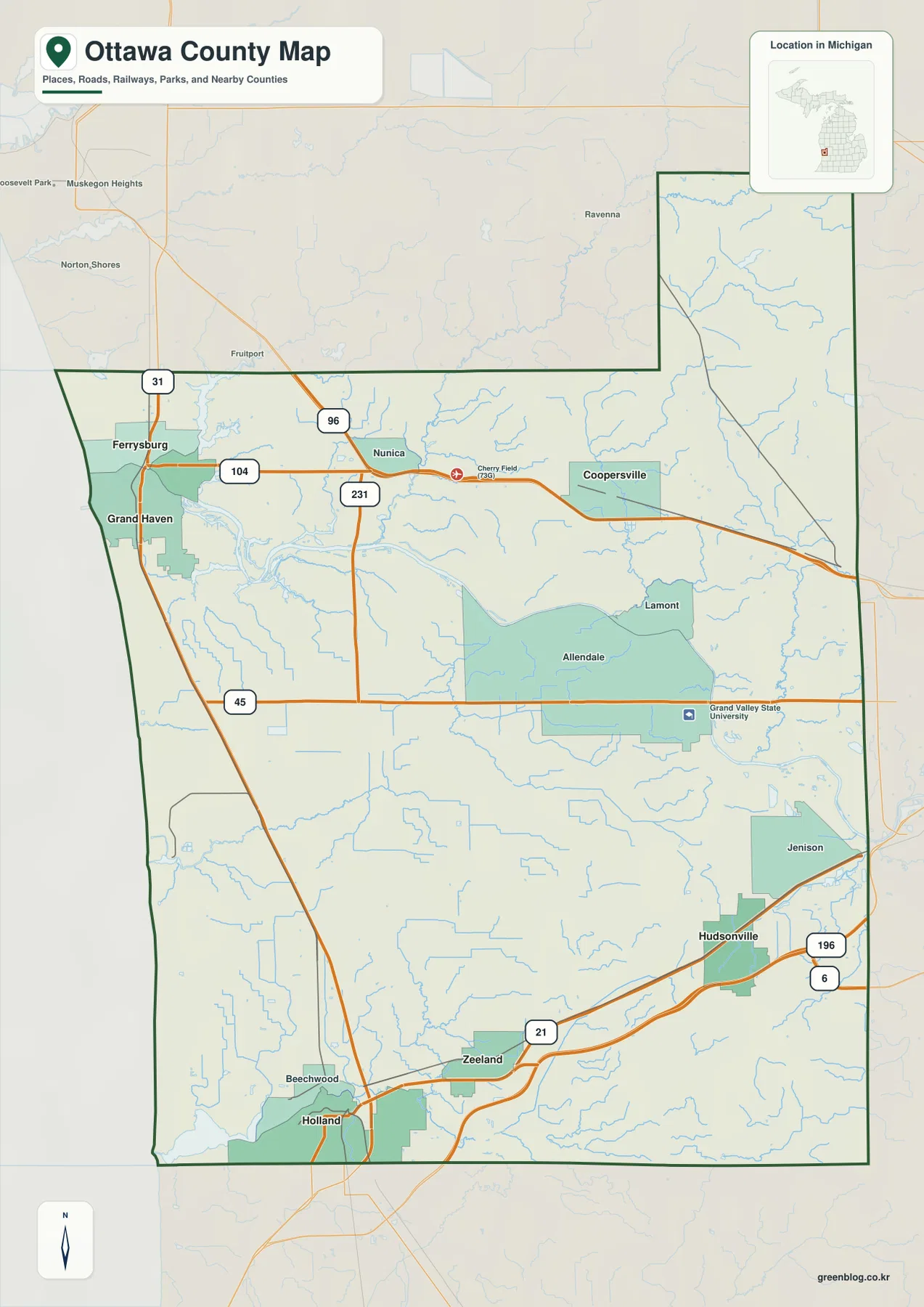
I-96 crosses the north-central interior near Coopersville and continues toward Kent County, providing a different east-west route from the southern I-196 corridor. M-45 runs across the central part of the county through Allendale, while M-104 and M-231 help explain movement around the Grand River. These roads are useful for orientation because they separate the shoreline, river, university, and southeastern suburban areas into recognizable zones. The map is not a live navigation product, however, so construction, closures, travel times, and current restrictions should be checked with a current road service.
The county boundary adds another layer of context. Muskegon County lies to the north, Kent County to the east, Allegan County to the south, and Lake Michigan forms the western side. That position helps explain why Ottawa County is both a lakeshore county and part of the broader Grand Rapids region. A visitor can begin at Grand Haven, follow the Grand River east, then compare the highway network around Allendale, Hudsonville, Zeeland, and Jenison to see how distinct parts of the county connect.
Six ranked cities reveal separate shoreline, interior, and southeast clusters
The city index highlights six places: Grand Haven, Hudsonville, Zeeland, Coopersville, Ferrysburg, and Spring Lake. The values printed in the index are 10,996 for Grand Haven, 7,769 for Hudsonville, 5,665 for Zeeland, 4,848 for Coopersville, 2,959 for Ferrysburg, and 2,519 for Spring Lake. Those figures belong to the supplied ranking graphic and should not be treated as a substitute for a current Census population lookup. Their main purpose here is to explain the order and geographic placement shown on the map.
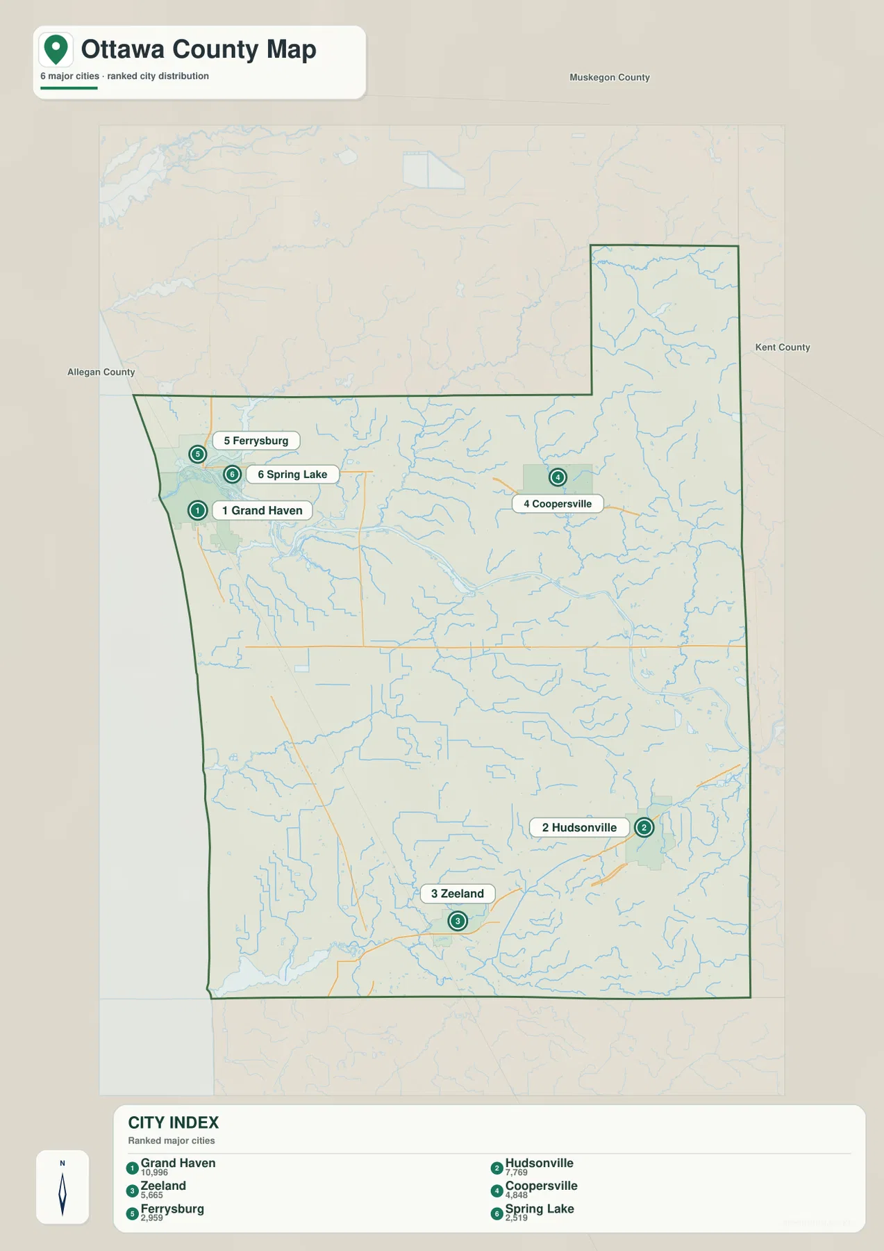
The distribution is more informative than the ranking alone. Grand Haven, Ferrysburg, and Spring Lake form a close western group around the Grand River mouth and nearby lake. Coopersville stands apart in the northeastern interior. Hudsonville lies in the southeast, while Zeeland is positioned farther southwest. The map therefore shows that the county’s principal settlements are not arranged around a single central city. They occupy several corridors shaped by the lakeshore, the Grand River, and roads leading toward Grand Rapids.
No connector lines or mileage labels appear on this city index. It should not be read as a straight-line-distance diagram or a driving-distance chart. Places such as Allendale, Jenison, Nunica, Lamont, and the Holland area also appear on the broader county map even though they are not part of the six-place ranking. Using both maps together prevents a common mistake: assuming that an index of selected cities is a complete list of communities or administrative units.
The Grand River dominates the center, but southern streams drain a different landscape
The terrain and water map is organized around the Grand River. It enters from the east, bends across the central portion of Ottawa County, and reaches Lake Michigan at Grand Haven. Numerous tributaries join the river from both sides, and Spring Lake appears close to the lower river near the shoreline. On this map the river is not just a blue line between towns; it is the broad natural corridor that separates parts of the county and helps explain the location of bridges, low ground, parks, and adjacent settlement.
South of the main river, Bass River forms another recognizable channel and passes near Bills Lake before joining the larger drainage network. In the northeastern extension, Crockery Lake and Mud Lake appear among many smaller streams, while Sand Creek runs close to the eastern boundary. These water features are smaller than the Grand River, but they make the county’s interior much more finely divided than a highway map alone suggests. They are useful landmarks when roads or communities are sparse.
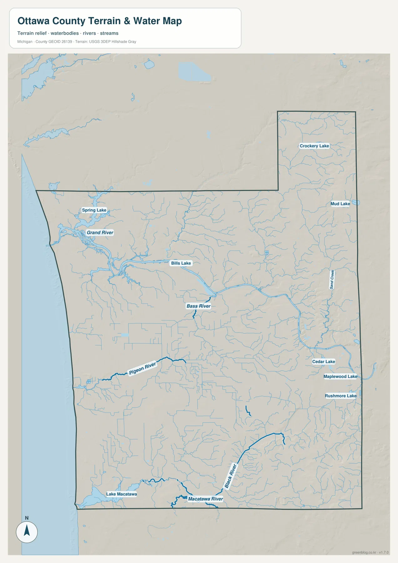
The southern half drains through a different set of waterways. The Pigeon River is labeled toward the southwest, and the Black River curves through the southeast before approaching the Holland lowlands. At the southern edge, the Macatawa River and Lake Macatawa form a distinct water feature near Holland. Cedar Lake, Maplewood Lake, and Rushmore Lake are also labeled farther east. Together these features show why the southern county should not be described simply as part of the Grand River basin without qualification; several smaller systems organize the land south of the main river.
This water map is a geographic reference, not a flood-hazard, wetland-boundary, navigation, or property-access map. It does not show water depth, current speed, legal access, or real-time conditions. Ottawa County Parks maintains sites along both the Grand River and the Lake Michigan shoreline, so anyone planning a visit should use the current park page for trail, launch, beach, and access information. The countywide map is best for understanding where those broad water environments sit in relation to one another.
Low river and shoreline terrain gives way to higher ground in the east and northeast
The elevation map makes the county’s relief easier to see than the road map does. Darker greens occupy much of the Lake Michigan side and the broad Grand River valley, indicating relatively low terrain. A wide low corridor follows the river through the center, while the shoreline also remains low overall. Small ridges near the lake break up that pattern locally, but the strongest contrast appears farther inland.
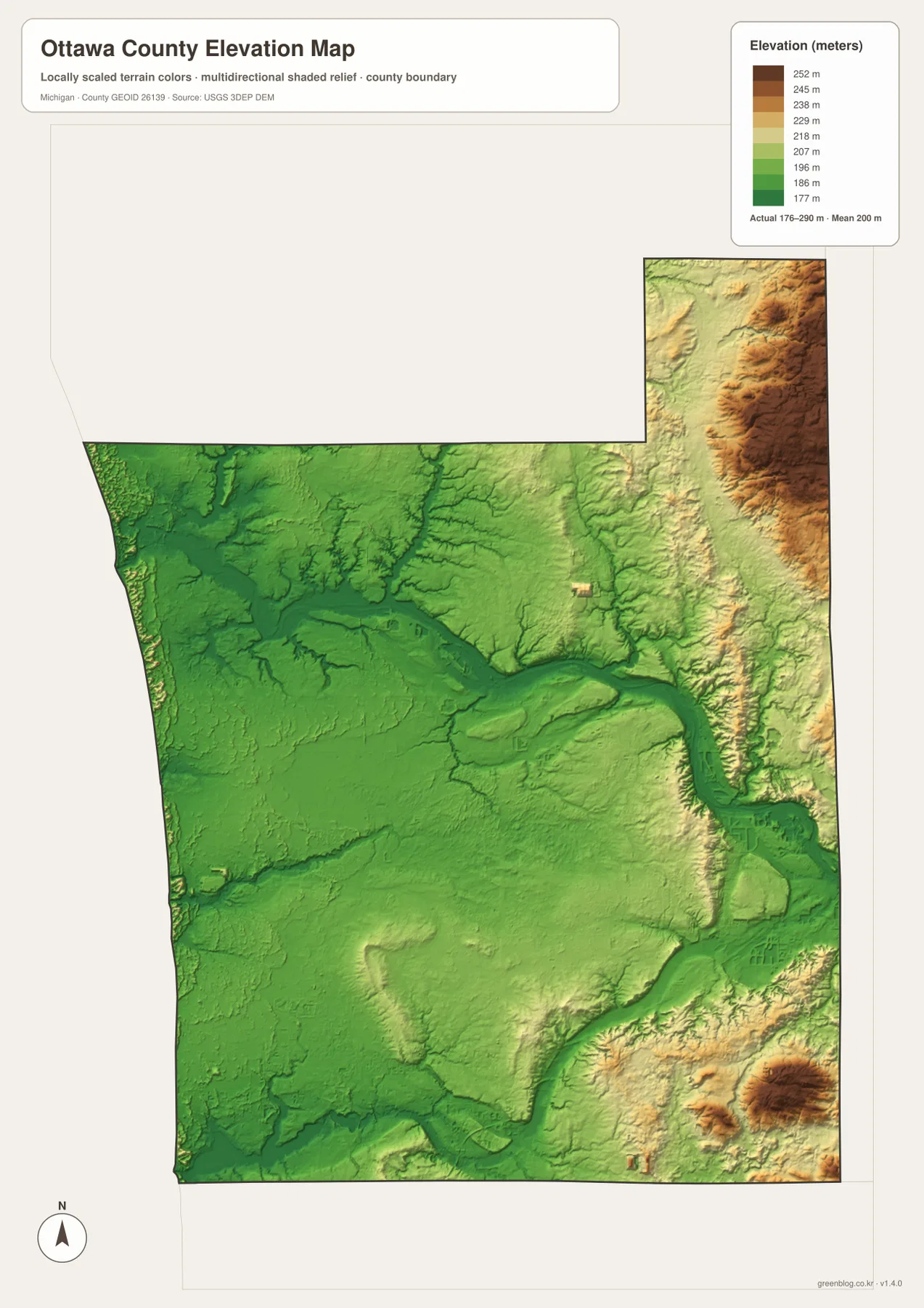
Yellow and brown tones become more common along the eastern edge and in the northeastern extension, where ridges and dissected slopes stand above the river lowlands. Additional higher patches appear in the southeast. The supplied legend uses representative color steps from roughly 177 to 252 meters, while the map separately notes an actual surface range of about 176 to 290 meters and a mean near 200 meters. Those two pieces of information should be kept separate: the top legend class is not the same thing as the absolute highest point in the county.
Comparing the relief map with the water map explains several patterns. The Grand River occupies a broad low route, and smaller tributaries cut into the higher eastern terrain. Sand Creek and other streams near the eastern edge follow narrow valleys that are easier to recognize once shaded relief is visible. The northeast stands out as one of the county’s higher areas, whereas Grand Haven and the river mouth sit in a much lower setting. This contrast is useful for regional orientation even though it is too generalized for site engineering or parcel-level elevation work.
The elevation surface should not be used as survey-grade measurement. It is suitable for seeing countywide differences, explaining why river valleys look lower than adjacent uplands, or adding terrain context to a presentation. Exact elevations for construction, drainage design, legal work, or a specific road segment should come from detailed USGS elevation data and, when required, professional field surveying.
Ottawa County is easiest to understand by switching between shore, river, and road views
For a quick orientation to Grand Haven, US-31, Coopersville, Allendale, Zeeland, and Hudsonville, start with the county map. The city index is useful when the goal is simply to compare the six ranked places, but it intentionally leaves out many communities and contains no distance measurements. The water map is the stronger choice for tracing the Grand River or separating it from the Bass, Pigeon, Black, and Macatawa systems. The elevation map adds the final layer by showing why the central river corridor and lakeshore are lower than much of the eastern interior.
Ottawa County’s official parks system reflects the same geographic variety. County park pages include sites on the Lake Michigan shoreline, along the Grand River, and in inland natural areas such as Crockery Creek and Pigeon Creek. A countywide map cannot replace the detailed map for an individual park, but it helps place those destinations within the larger landscape before a trip. Use the official park pages for current hours, access rules, trail conditions, launches, and facilities.
The download archive contains the original JPG versions of the four maps shown on this page: the county map, city index, terrain-and-water map, and elevation map. Each image is 2572 × 3638 pixels in an A3 portrait layout, which works well for enlargement on screen and for reference printing. They are appropriate for classroom use, presentations, regional orientation, and personal reference, but they should not replace legal boundary documents, navigation charts, flood products, or engineering data.
Frequently Asked Questions
Does the city index show distances between Grand Haven, Hudsonville, and Zeeland?
No. The index ranks six selected cities and marks their positions, but it does not draw connector lines or print mileage between them. Use the county map to see the relevant highway corridors, then consult a current routing service for driving distance and travel time. The index is designed for relative location, not route measurement.
Which map is best for following the Grand River to Lake Michigan?
The terrain-and-water map is the clearest option because it traces the Grand River across the county and shows Spring Lake, Bass River, tributaries, and the Lake Michigan shoreline. Pair it with the county map when you also need Grand Haven, Ferrysburg, M-104, M-231, or US-31. Together the two maps show both the river corridor and the roads and communities around it.
Can the 176-290 meter elevation range be used for precise site measurements?
No. That range summarizes the generalized countywide elevation surface, which is useful for comparing the low Grand River and lakeshore areas with higher eastern and northeastern ground. Parcel, road, drainage, or construction work requires more detailed elevation data and, when appropriate, field surveying.
Map File Information
Download the four high-resolution Ottawa County JPG maps used on this page in one ZIP archive.
- Included Files: county map, city map, water map, elevation map
- File Type: ZIP containing four JPG files
Related Maps
Sources and References
- Ottawa County, Michigan — official county information
- Ottawa County Parks & Recreation — county parks on the lakeshore, Grand River, and inland natural areas
- Grand River Park — official county page for a park along the Grand River
- U.S. Census Bureau – TIGER/Line Shapefiles — county boundaries and base geography
- U.S. Geological Survey – National Hydrography — rivers, streams, and lakes
- U.S. Geological Survey – 3D Elevation Program — elevation and terrain reference data
Green Map creates custom-edited map images using open geographic data sources such as geoBoundaries, Natural Earth, OpenStreetMap, and government open data. These maps are edited visual materials, not raw data files, and are provided for education, documents, presentations, and graphic reference.