Huron County occupies the outer part of Michigan’s Thumb, where Bad Axe sits inland while Caseville, Port Austin, Port Hope, Harbor Beach, and Sebewaing connect the county to long stretches of Saginaw Bay and Lake Huron shoreline. The official county overview describes Huron County as surrounded on three sides by water, and the supplied maps make that shape immediately clear. Low coastal ground wraps around much of the county, while higher rolling terrain rises across the south-central interior.
This page uses the supplied general county, city-distribution, terrain-and-water, and elevation maps to explain those differences. High-resolution JPG originals are available together in a ZIP download for printing, classroom materials, presentations, and detailed local reference. Reading the maps together makes it easier to connect Bad Axe and the shoreline towns with M-25, M-53, M-19, M-142, the river network, and the county’s gentle inland rise.
The road pattern is easiest to understand from Bad Axe. M-53 and M-142 provide strong central references, while M-25 follows much of the shoreline side through communities such as Sebewaing and Caseville before reaching the northern Thumb. M-19 provides another north-south reference south of Bad Axe near Ubly.
Table of Contents
Bad Axe anchors the interior while M-25 follows the shoreline
Bad Axe is the clearest road and settlement reference on the general county map. M-53 approaches the central area from the south, while M-142 crosses the county through the Bad Axe corridor toward Harbor Beach. McLaren Thumb Region Hospital is also labeled near town, adding a useful landmark in the middle of the county.
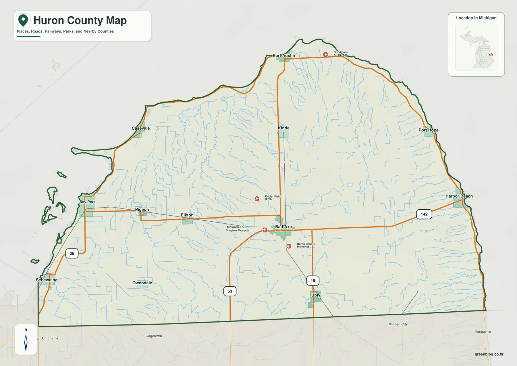
M-25 is the strongest shoreline road reference. It reaches the southwestern side near Sebewaing and Bay Port, continues toward Caseville, and helps orient the northern and eastern shoreline communities around the Thumb. The route pattern is very different from the straighter interior roads because it follows a county edge shaped by water.
North of Bad Axe, Kinde provides a useful midpoint before the county narrows toward Port Austin. Port Hope lies farther around the northeastern shore, and Harbor Beach anchors the eastern side. These communities are spread along the water-facing edge rather than clustered around one inland highway.
South of Bad Axe, M-19 leads toward Ubly while M-53 continues through another part of the southern interior. Pigeon and Elkton form a western inland cluster, with Owendale farther south. Away from Bad Axe, the road network becomes more rural and the numerous small streams become increasingly useful for orientation.
This is a regional reference map rather than a live navigation product. It does not show current traffic, road construction, accidents, winter conditions, or temporary closures. Current driving routes and travel conditions should be checked with up-to-date Michigan transportation information or a live navigation service.
Six highlighted communities spread from the interior to opposite shorelines
The city-distribution map highlights Bad Axe, Sebewaing, Harbor Beach, Pigeon, Ubly, and Elkton while removing most road detail. Bad Axe is near the center, Sebewaing lies on the southwestern shoreline, Harbor Beach is on the eastern Lake Huron side, Pigeon and Elkton sit to the west, and Ubly lies to the south. There are no connector lines or distance measurements, so this map should be used for relative position rather than travel distance.
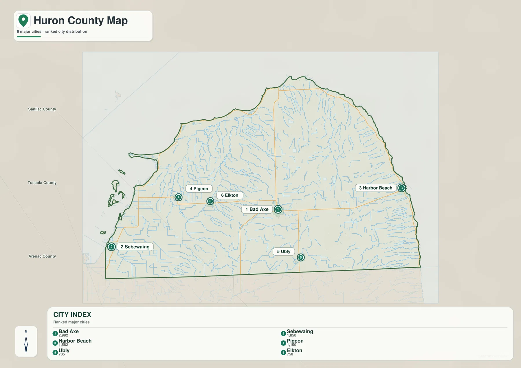
The CITY INDEX lists reference values of 2,992 for Bad Axe, 1,850 for Sebewaing, 1,582 for Harbor Beach, 1,170 for Pigeon, 785 for Ubly, and 750 for Elkton. These figures are best treated as ranking values used for the map rather than as the latest official population counts. Current population estimates should be checked in the relevant U.S. Census Bureau release.
Bad Axe is the largest highlighted community and the strongest inland reference. Harbor Beach and Sebewaing sit on opposite sides of the county, giving the city map a useful east-west shoreline contrast. Pigeon and Elkton occupy the western interior, while Ubly represents the southern part of the Thumb.
The simplified view also shows why Huron County cannot be understood as one continuous urban corridor. Communities are separated by broad agricultural and stream-filled areas, and coastal places face different bodies of water around the Thumb. The general map adds the roads needed to understand how those settlements are actually connected.
Port Austin, Caseville, Port Hope, Kinde, Bay Port, and Owendale appear on the general map but are not part of the six-city ranking. Use the distribution view for the highlighted communities and return to the general map when the full shoreline and road network matter.
Pinnebog, Pigeon, and Willow rivers drain a county surrounded by water
Huron County’s official overview notes that the county is surrounded on three sides by Saginaw Bay and Lake Huron. The terrain-and-water map shows that broad water setting clearly, with the western, northern, and eastern county edges meeting open water. Inside the Thumb, numerous short rivers, creeks, and drains run outward toward the shoreline.
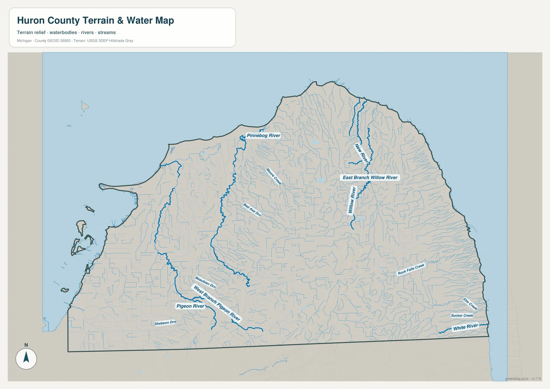
Pinnebog River is one of the strongest western and northwestern drainage references. Smaller tributaries and drains join it as it crosses the interior toward the shoreline. Moore Drain and Bear Ann Drain are also labeled nearby, showing how dense the agricultural drainage network becomes west of the county center.
Pigeon River and West Branch Pigeon River dominate the southwestern and west-central side. Shebeon Drain and many smaller channels feed this system across the Pigeon–Elkton area. Unlike counties organized around one large river, Huron County contains numerous modest waterways spread across a broad, gently sloping landscape.
Willow River, East Branch Willow River, and New River are prominent in the northeast. Along the eastern side, Rock Falls Creek, Elm Creek, Sucker Creek, and White River run through short valleys toward Lake Huron. The repeated coastward drainage lines are especially clear when this map is compared with the elevation view.
This water map is a geographic reference, not a flood, navigation, depth, water-quality, or legal-access product. It does not provide current water levels, channel suitability, flood status, or property rights. Boating, fishing, drainage planning, and flood preparation should use current Michigan and federal information in addition to this county-scale view.
Coastal lowlands rise into the south-central interior
The elevation legend reports an actual range of about 175 to 265 meters with a mean of 209 meters. Dark green marks the lower parts of Huron County, lighter green and yellow indicate intermediate terrain, and orange to brown identifies the higher ground. The palette is locally scaled, so the same color on another county map should not be assumed to represent the same elevation.
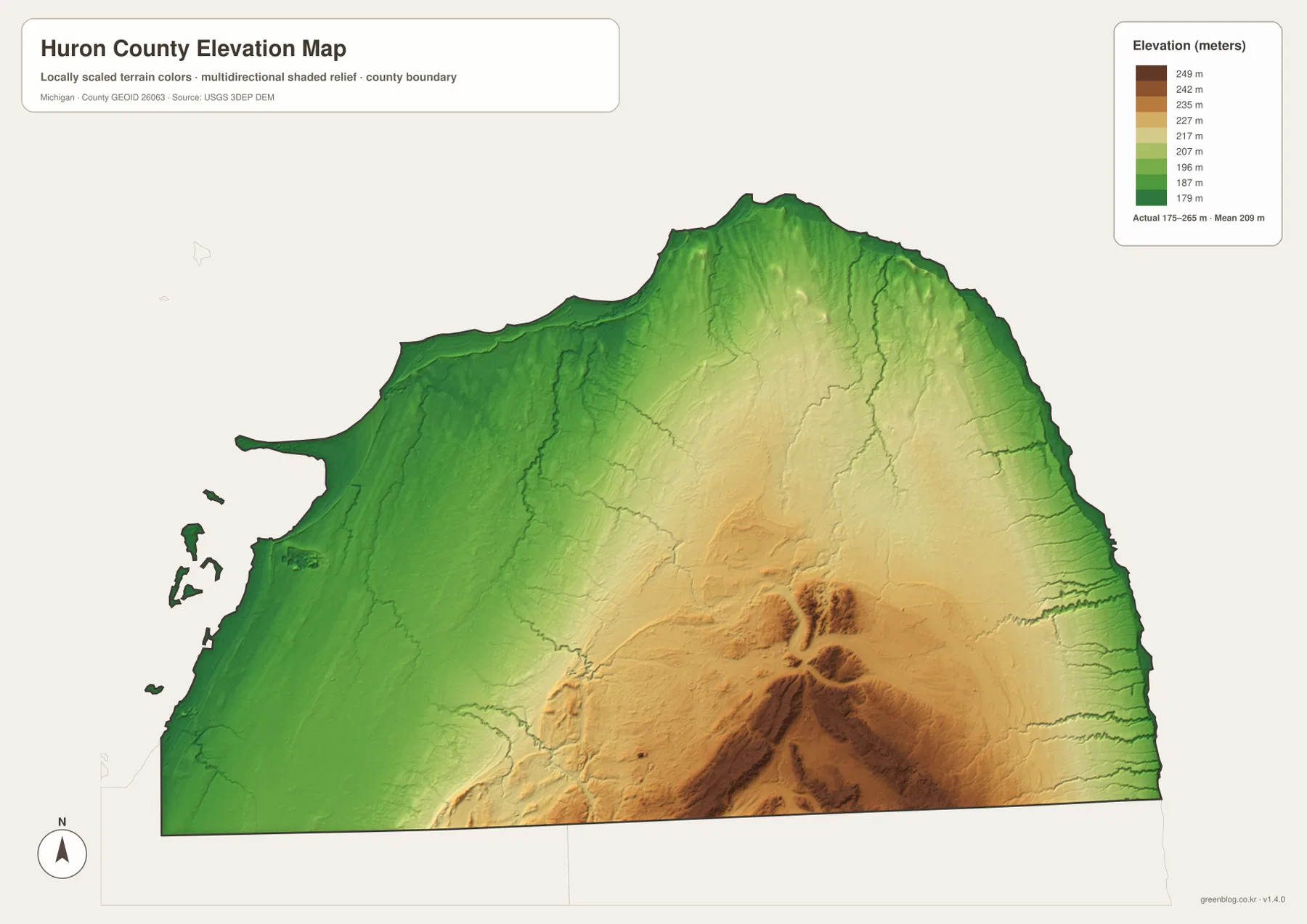
The broadest low terrain follows the western Saginaw Bay shoreline and the northern and eastern Lake Huron edges. Caseville, Port Austin, and Harbor Beach all sit close to green coastal ground, and the river valleys extend those lower elevations inland. The county’s unusual water-wrapped boundary makes this coastal lowland especially prominent.
Moving inland, elevations rise gradually through light green and yellow terrain. Bad Axe occupies a moderate interior setting rather than the lowest shoreline or the highest southern ridge area. The Pinnebog, Pigeon, and Willow river systems create lower corridors through this otherwise gentle rise.
The strongest orange and brown terrain is concentrated across the south-central interior and extends toward the southeast. Some ridges reach above 240 meters on the local legend, with the county maximum near 265 meters. This higher ground stands clearly above the shoreline lowlands even though the overall terrain remains much gentler than a mountain county.
Streams cut outward from the higher interior toward lower coastal areas, creating narrow green valleys through the yellow and orange terrain. This county-scale elevation surface is useful for broad comparison but is not survey-grade or engineering-grade measurement. Exact parcel elevations, drainage design, construction, and slope calculations require authoritative detailed data such as the USGS 3D Elevation Program.
Bad Axe and the three-sided shoreline reveal Huron County’s main contrasts
Bad Axe is the best starting point for comparing the maps. M-53 and M-142 provide strong road references, the city map makes Bad Axe the largest highlighted community, and the elevation surface places it between the lowest coastal ground and the higher south-central ridges. It functions as the clearest inland reference for the entire county.
The Caseville–Bay Port–Sebewaing side represents the Saginaw Bay shore. M-25 is the major road reference, while Pinnebog and Pigeon river systems drain toward the western water. The elevation map shows broad green lowlands along this side compared with the higher inland terrain.
Port Austin and Port Hope define the narrow northern and northeastern Thumb. Coastal ground remains low, while Willow River and New River drain through the interior toward the water. Because the county narrows here, the western and eastern shorelines are geographically much closer than they are farther south.
Harbor Beach anchors the eastern Lake Huron side. M-142 connects the area back toward Bad Axe, while White River, Sucker Creek, Elm Creek, and Rock Falls Creek provide repeated drainage references along the eastern slope. The elevation map shows a clear rise from the coast toward the interior.
For practical use, the general map is best for roads and named places, the city map for relative settlement positions, the water map for the surrounding shoreline and river systems, and the elevation map for the coast-to-interior relief change. Used together, the maps provide a much clearer picture of Michigan’s Thumb than any single view.
Choosing a Huron County map and using the high-resolution files
Use the general county map when you need Bad Axe, Harbor Beach, Port Austin, Caseville, Sebewaing, M-25, M-53, M-19, and M-142 in one view. The city-distribution map is cleaner when the main question is where the six highlighted communities sit within the county. Choose the terrain-and-water map for Pinnebog, Pigeon, Willow, and White river systems, and the elevation map when the contrast between coastal lowlands and the south-central interior is the main subject.
The WebP images on this page are optimized for browser viewing. The ZIP below contains the original high-resolution JPG versions of the general county map, city-distribution map, terrain-and-water map, and elevation map. Those originals are better suited to printing, classroom handouts, presentations, and large displays where additional image detail is useful.
Frequently Asked Questions
Which map is best for finding Bad Axe, Harbor Beach, and Sebewaing together?
Use the general county map. It shows M-53 and M-142 around Bad Axe, the eastern route toward Harbor Beach, and the M-25 shoreline side near Sebewaing and Caseville. The city-distribution map is also useful when you only need the relative positions of the highlighted communities.
Which map shows Pinnebog River and Pigeon River?
Use the terrain-and-water map. It shows Pinnebog River, Pigeon River, West Branch Pigeon River, Willow River, East Branch Willow River, New River, White River, Sucker Creek, and other coastal streams. It is a location reference and does not provide flood, depth, navigation, water-quality, or access information.
Where does Huron County appear highest on the elevation map?
The strongest high terrain is concentrated across the south-central interior and extends toward the southeast, while the Saginaw Bay and Lake Huron shorelines are generally lower. The legend reports an actual range of roughly 175 to 265 meters with a mean of 209 meters, but exact site elevations should be checked in authoritative elevation data.
Map File Information
The ZIP contains the high-resolution JPG originals for the Huron County general map, city-distribution map, terrain-and-water map, and elevation map.
- Included Files: general county map, city-distribution map, terrain-and-water map, elevation map
- File Type: JPG
Related Maps
Sources and reference links
For county government and local information, see the official Huron County website and Huron County About Us. For boundary and road-reference data, consult U.S. Census Bureau TIGER/Line. Water features can be cross-checked with USGS National Hydrography, and elevation data with the USGS 3D Elevation Program. These page maps are general reference products and do not replace legal boundaries, surveys, navigation charts, or flood determinations.
Green Map creates custom-edited map images using open geographic data sources such as geoBoundaries, Natural Earth, OpenStreetMap, and government open data. These maps are edited visual materials, not raw data files, and are provided for education, documents, presentations, and graphic reference.