York County occupies the southwestern corner of Maine, extending from the Biddeford-Saco coastal area through Sanford and Alfred to Kittery, York Harbor, and the state line near New Hampshire. The maps show a county with several distinct settings rather than one uniform landscape: a more concentrated northeastern coast, a broad inland road network, lake and stream country in the northwest, and a southern shoreline shaped by rivers and the Atlantic. This page explains those geographic relationships and provides the same map themes as high-resolution JPG files in a downloadable ZIP archive.
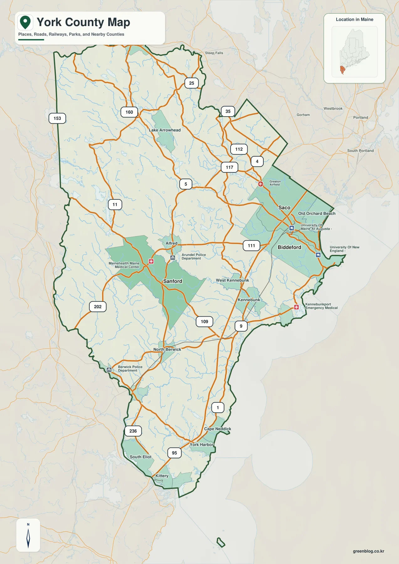
York County Government describes the county as a local government in continuous existence since 1636, and its official annual report identifies Alfred as the county seat. The current county website lists 29 municipalities. The supplied road map highlights useful reference points among them, including Biddeford, Saco, Sanford, Alfred, Kennebunk, North Berwick, Kittery, and York Harbor. Cumberland County lies beyond the northern edge, New Hampshire is close to the western and southwestern side, and the Atlantic coast defines much of the eastern and southern outline.
Table of Contents
Biddeford and Saco make the northeastern road network easy to enter
Biddeford and Saco sit close together in the northeastern part of York County and form the most obvious urban pair on the general map. U.S. 1 and I-95 both pass through this side of the county, giving readers two strong north-south references before they look at the smaller state routes. Old Orchard Beach appears near the coast to the northeast, while Route 111 heads inland from the Biddeford area toward Sanford. This concentration of names and highways makes the Biddeford-Saco area a practical starting point for reading the entire county.
North and west of Saco, Routes 112, 117, 4, and 5 separate into different inland directions. Lake Arrowhead is a prominent landmark farther northwest, with Routes 160 and 25 helping to organize the upper part of the map. South of Biddeford, Kennebunk and West Kennebunk appear along the transition toward the lower coast, while U.S. 1 and I-95 continue south. Looking for the largest roads first makes it easier to place the smaller communities without trying to read every label at the same time.
The contrast between the coast and the interior is already visible in the road layer. Around Saco and Old Orchard Beach, settlement labels and roads are relatively close together. Moving west, the spacing increases and smaller streams become more prominent. Route 5 and Route 11 are useful references in these inland sections, while U.S. 202 provides a major north-south guide closer to the western side of York County.
This overview is not a live traffic or construction map. Conditions on I-95, U.S. 1, and the state routes can change with weather, maintenance, and seasonal travel. For actual driving, current MaineDOT information and a navigation service should be used. The value of this county map is orientation: seeing which communities are near the main highways and how the road network changes between the coast and the interior.
Sanford and Alfred shift the focus from the coast to inland connections
Sanford is one of the strongest inland labels on the map. Route 111 approaches from the Biddeford side, Route 109 continues south, and U.S. 202 runs nearby on the western side. Together, those roads show that Sanford is not simply an extension of the coastal corridor. It occupies a different part of the county where several inland directions matter, making it a useful reference for trips between the coast, western communities, and the New Hampshire side.
Alfred appears northeast of Sanford near the Route 111 and Route 4 area. York County’s official annual report identifies Alfred as the county seat, which gives the place administrative importance even though the road map is not trying to rank communities by size. On this map, Alfred also works well as a geographic hinge between the Biddeford-Sanford connection and the roads leading farther north.
South of Sanford, North Berwick becomes a useful landmark before the county narrows toward South Eliot and Kittery. Route 236 follows the southwestern side toward Kittery, while Route 9 and U.S. 1 are more visible closer to the coast. Because New Hampshire lies immediately beyond this part of the county, the relationship to Portsmouth and the lower Piscataqua region becomes geographically relevant even though those places are outside York County.
The upper northwestern area is noticeably different. Routes 153, 160, and 25 cross a region with fewer large settlement labels and many small lakes and streams. Lake Arrowhead stands out as one of the easiest water landmarks. The farther the map moves from the coast, the less dominant I-95 and U.S. 1 become, and the more important state highways and local roads are for understanding the shape of the county.
The Biddeford hub map is best read as a location and straight-line distance guide
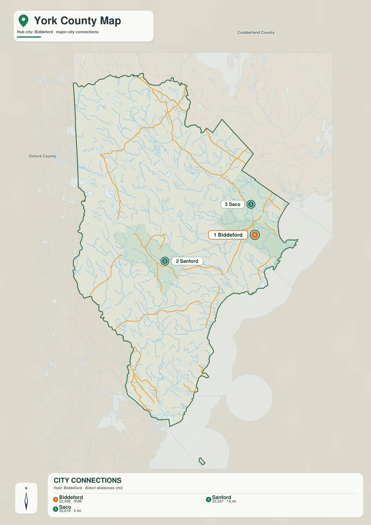
The City Connections graphic uses Biddeford as the hub and marks Sanford and Saco as the other ranked cities. Its lower index prints the values 22,498 for Biddeford, 22,247 for Sanford, and 20,819 for Saco. Because the image does not state the reference year or statistical definition for those figures, they should not be presented as current population counts. Current demographic figures should come from the latest U.S. Census Bureau data instead.
The distance labels are more clearly defined. The map explicitly identifies them as direct distances from Biddeford: Saco is shown at 5 miles and Sanford at 14 miles. These are straight-line measurements, not driving distances. Real road travel follows bridges, intersections, and routes such as Route 111, so mileage and travel time can differ substantially from the numbers printed in the graphic.
With most smaller place names removed, the distribution of the three marked cities becomes easy to understand. Biddeford and Saco form a close northeastern coastal pair, while Sanford sits farther west in the interior. Large portions of southern York County around Kittery and York, along with the northwestern lake region, remain outside this three-city emphasis. That makes the graphic useful for a quick urban comparison without suggesting that it represents every important community.
For a presentation, this simplified view is cleaner than the full road map. For route planning or explanations of how Sanford connects with the coast, however, the general county map is more useful because it retains Route 111, Route 109, U.S. 1, I-95, and the surrounding communities. The two images answer different questions and are most effective when used together.
The Saco River defines the northeast while the Mousam system crosses the center
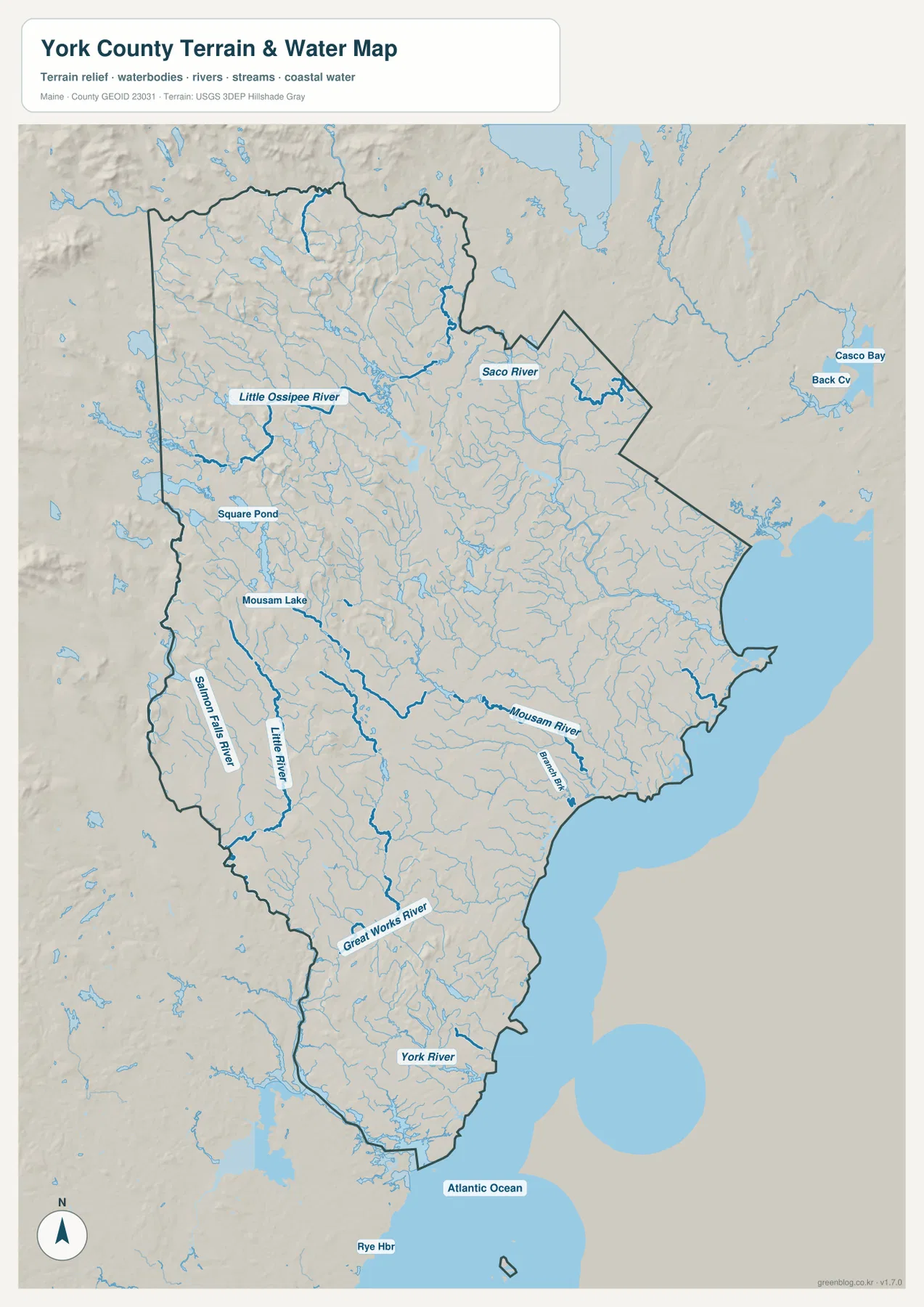
The terrain-water map makes the northeastern Saco River one of the county’s clearest natural features. It bends across the upper-right part of York County toward the Biddeford-Saco coast. Farther west, the Little Ossipee River forms another recognizable watercourse across the northern interior. Comparing these rivers with Routes 25, 160, and 112 helps explain why the upper county contains a dense network of streams even where the road map has relatively few large place labels.
The Mousam River becomes the stronger reference through the central and southeastern part of the county. Mousam Lake sits inland, and connected waterways extend toward the Kennebunk side of the coast. Numerous small tributaries surround this system. That pattern shows that the area between Sanford and Kennebunk is not a featureless inland plain; it contains many stream valleys and gentle changes in relief that influence the shape of local roads.
Along the western side, the Salmon Falls River is labeled as a long boundary-side waterway, with the Little River farther inside the county. The Salmon Falls River is especially useful for locating the New Hampshire-facing edge of York County. Farther south, the Great Works River appears before the map reaches the Kittery and South Eliot area, where river mouths and coastal water become increasingly important.
Shaded relief adds a sense of the land surface without turning the map into a precise elevation model. The western and northwestern interior appears more rolling, while the areas closer to the coast are generally lower and smoother in the image. Exact elevation, slope, engineering, or survey measurements should not be derived from the shading. For that work, authoritative data such as the USGS 3D Elevation Program is the appropriate source.
The York River and southern coast explain the county’s narrow lower end
Near the southern coast, the York River reaches toward the Atlantic and provides a strong natural reference for the York Harbor and Cape Neddick area. The Great Works River and Salmon Falls River lie farther west, while Rye Harbor is labeled outside the county in New Hampshire. Rivers, state boundaries, and ocean water all come close together here, producing a map pattern very different from the broad northwestern interior.
Kittery sits near the southern tip of York County, and both U.S. 1 and I-95 continue in this direction. The road map emphasizes transportation, but the terrain-water view makes the fragmented shoreline and river-influenced land shape more obvious. Looking at the two together helps explain why coastal travel does not follow simple straight lines and why major roads converge on a limited number of crossings and corridors.
Square Pond and Mousam Lake are useful inland water landmarks farther north and west. Square Pond lies south of the Little Ossipee River area, while Mousam Lake provides a strong reference northwest of Sanford. Smaller tributaries connect the interior lakes to the broader river systems, and the water network becomes increasingly tied to tidal and coastal environments toward the east and south.
This terrain-water image is not a flood map, nautical chart, depth map, or legal water-boundary survey. It does not provide tides, navigation channels, real-time river levels, flood probabilities, or parcel ownership. Boating, coastal safety, and flood decisions require current products from NOAA, FEMA, USGS, and relevant Maine agencies. The map here is intended to show the relative positions of rivers, ponds, shoreline, and terrain.
Choose the map by the part of York County you need to explain
The general county map is the strongest starting point for Biddeford, Saco, Sanford, Alfred, Kennebunk, Kittery, U.S. 1, I-95, U.S. 202, and the state highways. It keeps roads, communities, boundaries, and broad water features in one view. For regional orientation, it provides more context than the other supplied images and is the best option before narrowing the discussion to cities or hydrology.
The City Connections graphic is better when the question is simply how Biddeford, Saco, and Sanford relate to one another. Its direct-distance labels are easy to read, provided they are not confused with driving mileage. The terrain-water map serves a different purpose by making the Saco, Mousam, Salmon Falls, Great Works, and York river systems much more prominent. Switching between the road and water views helps explain why different parts of the county have such different settlement and transportation patterns.
The downloadable originals are high-resolution JPG files measuring 2572 × 3638 pixels each. They can be placed on a full document page or enlarged around a specific area for classroom material, presentations, and personal reference. Enlarging the images does not add live traffic, parcel boundaries, precise elevation, flood zones, or nautical information, so specialized work should be checked against current official sources.
York County changes noticeably from the urbanized northeastern coast to the Sanford-Alfred interior, the long southern section around Kittery and York Harbor, and the lake-and-stream country in the northwest. Starting with the map that best matches the question keeps that variety understandable without forcing every detail into a single view.
Frequently Asked Questions
Are the 5 miles to Saco and 14 miles to Sanford actual driving distances from Biddeford?
No. The City Connections graphic explicitly labels them as direct distances from Biddeford. They are straight-line measurements, not road mileage. Real driving follows the road network, bridges, intersections, and routes such as Route 111, so current navigation should be used for an actual trip.
What are the easiest landmarks for comparing the York County coast with the interior?
On the coast, Biddeford, Saco, Kennebunk, Kittery, U.S. 1, and I-95 provide strong references. Inland, Sanford, Alfred, U.S. 202, Route 111, Route 109, Lake Arrowhead, and Mousam Lake are useful anchors. Adding the Saco and Mousam rivers makes the relationship between transportation and water much clearer.
Why is the Salmon Falls River useful on the York County water map?
The Salmon Falls River is a prominent western and southwestern waterway near the New Hampshire-facing edge of York County, so it helps orient the state-boundary side of the map. Farther south, the Great Works and York rivers provide additional references near Kittery and York Harbor. Legal boundaries, flood conditions, and navigation details should still be verified with specialized official sources.
Map File Information
The ZIP archive contains high-resolution JPG maps of York County matching the map themes described on this page.
- Included Files: county and major roads map, City Connections map, terrain and water map
- Printable Size: 2572 × 3638 pixels each
- File Type: JPG
Related Maps
Sources and References
- York County Maine Government – Official Website
- York County Maine Government – Towns of York County
- U.S. Census Bureau – TIGER/Line Shapefiles
- USGS – National Hydrography
- USGS – 3D Elevation Program
Green Map creates custom-edited map images using open geographic data sources such as geoBoundaries, Natural Earth, OpenStreetMap, and government open data. These maps are edited visual materials, not raw data files, and are provided for education, documents, presentations, and graphic reference.