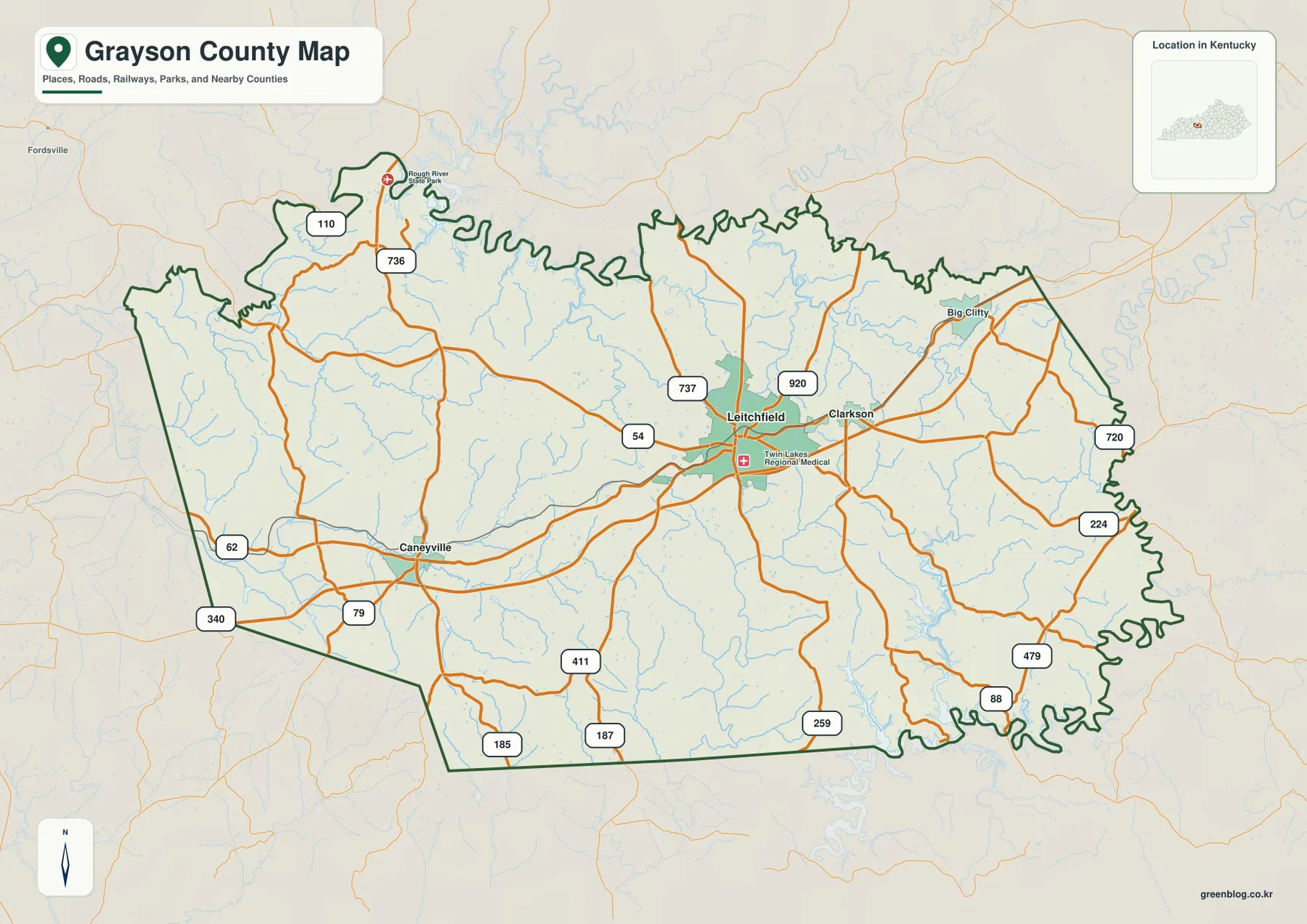
Grayson County sits in west-central Kentucky around Leitchfield, with Clarkson close to the east, Caneyville to the west, and smaller communities connected by winding roads and creek valleys. Nolin River Lake reaches the southeastern side of the county, while the Rough River lake area lies near the north, giving the county a distinctive setting between two major reservoirs. This page includes a detailed county map, a city-connection map, a terrain-and-water map, and an elevation map, and all four high-resolution JPG originals can be downloaded together in a ZIP file. High-resolution map files are available for download in the section below.
Leitchfield is the easiest place to establish orientation. Clarkson is only a short distance east of it, while Caneyville is farther west across a more rural part of the county. Routes marked 54, 259, 88, 79, 62, and 920 connect these areas with smaller roads that bend through low valleys. The county map also marks Big Clifty and Rough River Dam State Park, so the central city, lake approaches, and northern recreation area can be compared on the same sheet.
Table of Contents
Leitchfield anchors the roads to Clarkson, Caneyville, and the county edges
Leitchfield lies slightly east of the county’s center and is the clearest road hub on the detailed map. Route 54 runs west toward Caneyville, while Route 259 heads south toward the Nolin River Lake side of the county. Clarkson sits immediately east of Leitchfield, and the close spacing between the two cities makes the central-eastern part of Grayson County look more connected than the more dispersed western countryside.
Several numbered roads help divide the outer parts of the county into recognizable sections. Routes 920 and 720 serve the northeast around Big Clifty, while 88 and 479 appear along the southeastern side. South and southwest of Leitchfield, routes 187, 185, and 79 cross a landscape of short ridges and stream valleys. These road lines are most useful for geographic orientation; they are not a substitute for turn-by-turn navigation, closures, or current road conditions.
The county boundary also says something about the landscape. Its northern edge is highly irregular near the Rough River drainage, and the southeastern edge becomes even more intricate around the Nolin River Lake system. By contrast, parts of the west and southwest are straighter. That combination makes Grayson County easy to recognize: a road-focused center around Leitchfield, with deeply indented water-and-valley edges toward the north and southeast.
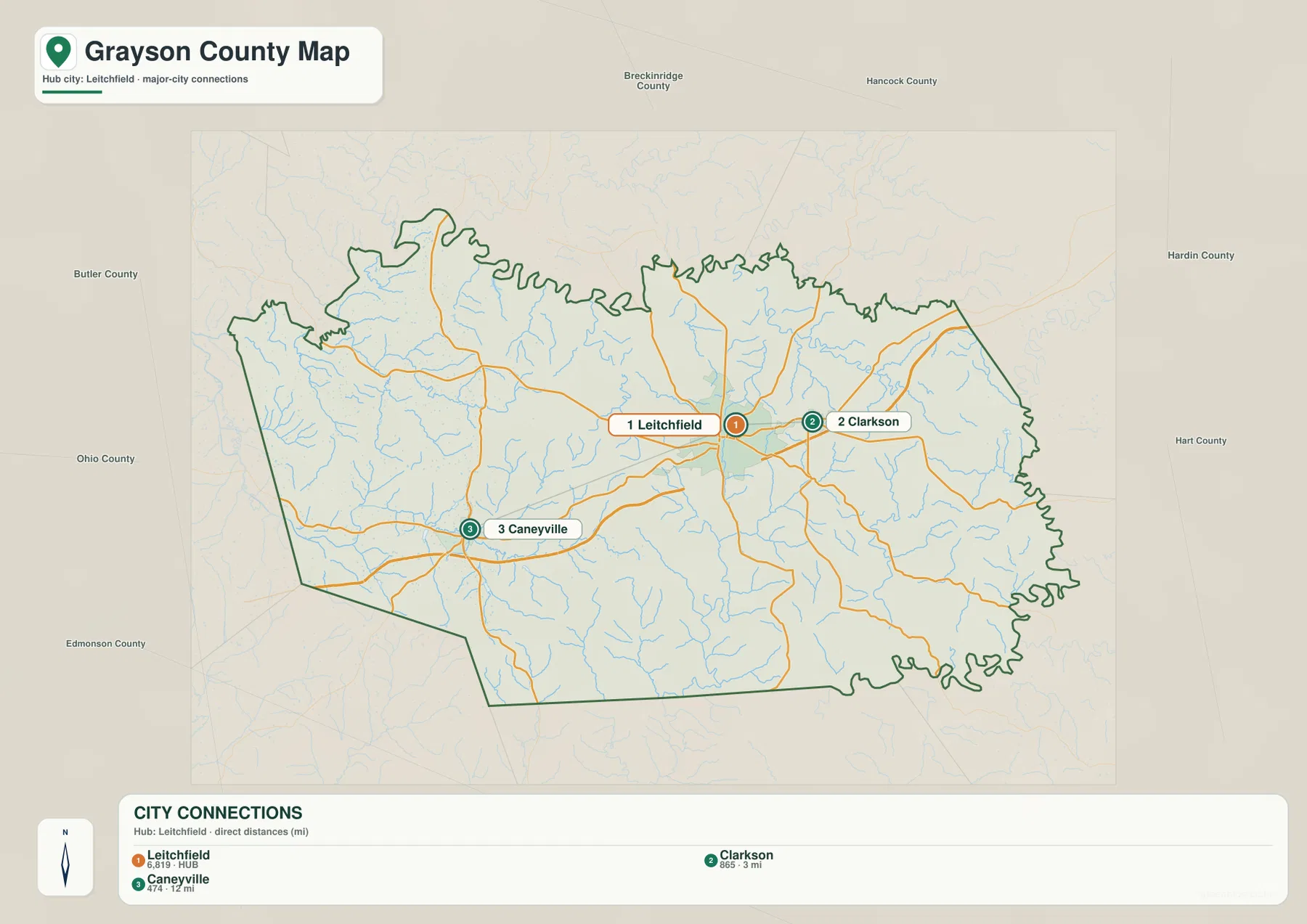
Clarkson is about 3 miles from Leitchfield, while Caneyville is about 12 miles away
The city-connection map strips away most of the road detail and ranks three principal cities. Leitchfield is the hub and is labeled with a population of 6,819. Clarkson is labeled 865 and sits about 3 miles from the hub by the map’s straight-line measure, while Caneyville is labeled 474 and is about 12 miles away. These distances are not driving distances, but they make the east-west spacing of the county’s main city references immediately clear.
Clarkson’s close position beside Leitchfield explains why the two places look almost continuous when viewed at county scale. East of Clarkson, roads continue toward Big Clifty and the Nolin River Lake area. Caneyville is a separate western reference point and is more useful when locating the western reservoirs, smaller roads, and creek valleys. For a quick mental map, it helps to think of Leitchfield and Clarkson as the central-eastern pair and Caneyville as the western anchor.
The simplified city view does not include every named community. Big Clifty appears on the detailed county map but not in the ranked city panel, and many rural places around the lakes and creeks are omitted as well. That is why the city map works best for comparing the main urban reference points, while the county map provides the finer place names and road connections needed for a specific destination.
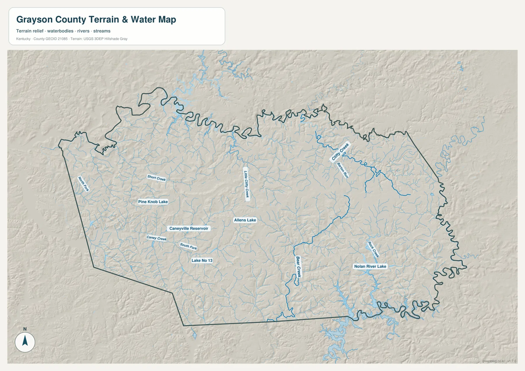
Clifty Creek, Bear Creek, and small reservoirs fill the ground between the two lake regions
Nolin River Lake is the dominant water feature on the southeastern side of the terrain-and-water map. Peter Creek enters the lake area from the north, while Clifty Creek and Barton Run occupy the northeastern drainage. The stream lines form branching valleys rather than one broad flat corridor, which matches the winding road pattern visible on the detailed county map.
South of the county center, Bear Creek runs through a long low corridor before reaching the lake network. The western half contains Caney Creek and South Fork near Caneyville Reservoir, with Pine Knob Lake, Allens Lake, and Lake No 13 adding smaller water landmarks. North Fork and Short Creek appear farther west and northwest, while Little Clifty Creek crosses the interior. Together they show how many short drainage valleys divide the uplands between Leitchfield, Caneyville, and the lake margins.
Grayson County tourism materials describe the county as lying between Rough River Lake and Nolin Lake, and that regional setting is useful for understanding the map. The two larger lake systems sit near opposite sides of the county, while a dense web of creeks and smaller reservoirs occupies the land between them. The water map is a geographic reference rather than a flood-hazard, legal-boundary, or real-time lake-level product, so current water and regulatory information should be checked through the appropriate official source.
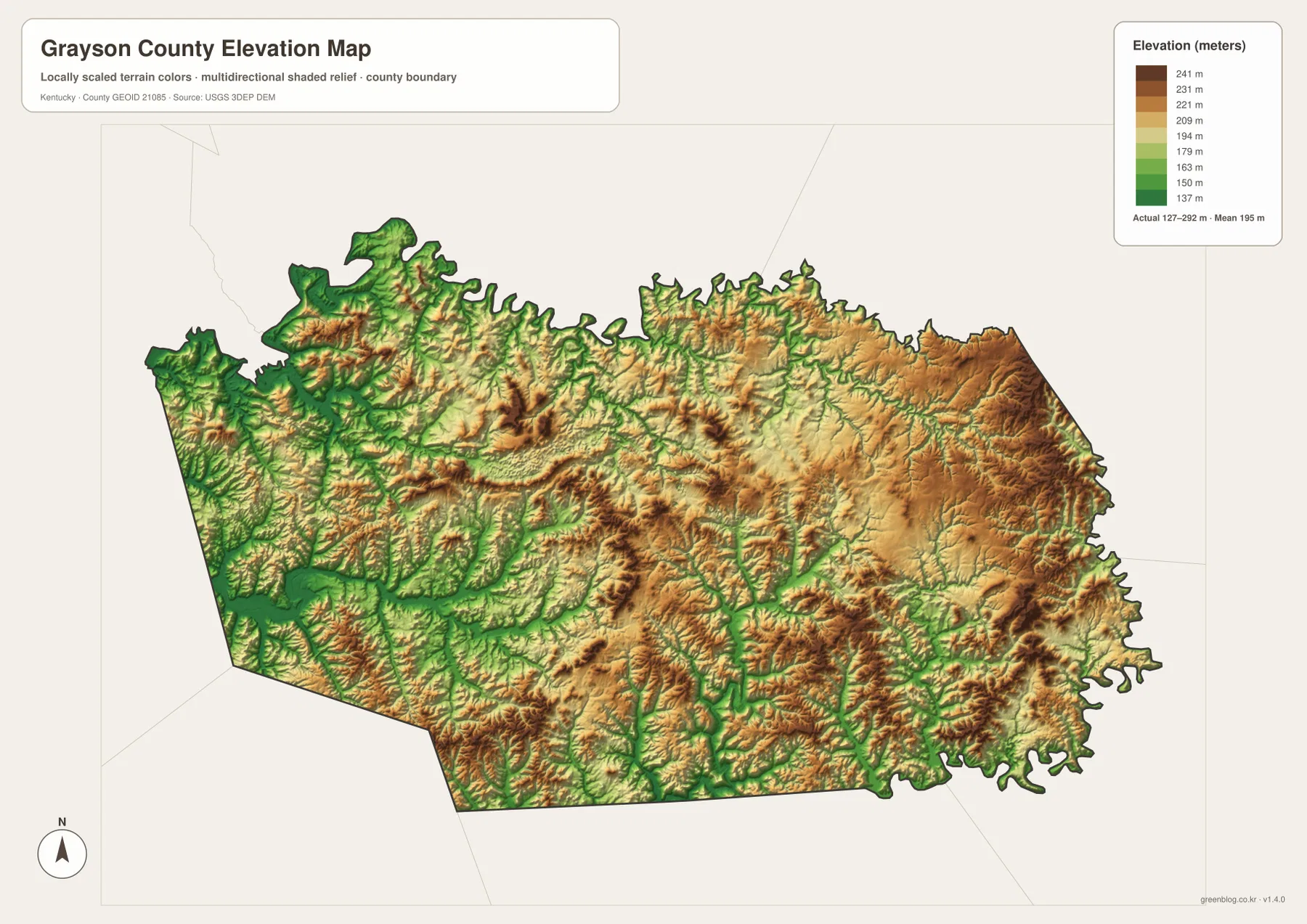
The 127–292 m elevation range separates eastern ridges from lower creek corridors
The elevation map reports an actual range of about 127 to 292 meters and a mean of 195 meters. A difference of roughly 165 meters is enough to create a clearly rolling landscape, with short ridges repeatedly broken by streams. Higher brown and tan areas are most extensive in the eastern and southeastern parts of the county, while lower green bands follow many western valleys and major drainage lines.
The Nolin River Lake side of the county combines low water margins with closely packed higher ridges nearby. Similar low strips follow Clifty Creek, Bear Creek, and Caney Creek, and the terrain rises again between those channels. When this surface is compared with the road map, many of the curving secondary roads make more sense because they pass along valleys or around ridge ends rather than crossing the landscape in straight lines.
This is a generalized county-wide elevation surface, not a survey or engineering measurement for a parcel, building site, bridge, or road project. Its strength is comparison: it shows where the broad low corridors lie, where the eastern uplands rise, and how lake arms and tributaries cut into the surrounding ground. For small labels and precise geographic orientation, it should be read alongside the water and county maps rather than by itself.
Start with the map that matches whether you are looking for a town, road, lake, or ridge
For Leitchfield, Clarkson, Caneyville, Big Clifty, or a numbered highway, the detailed county map is the most direct starting point. It combines place names, roads, the county boundary, and nearby landmarks. If the only question is how the three ranked cities relate to one another, the city-connection map removes most of the extra detail and makes the Leitchfield–Clarkson–Caneyville spacing easier to compare.
For Nolin River Lake, Clifty Creek, Bear Creek, Caneyville Reservoir, or another water-based landmark, the terrain-and-water map is more useful. It labels many channels that are barely visible on the road map. The elevation map adds a second layer by showing whether a creek occupies a broad low corridor or a narrow valley between higher ridges, which is especially helpful on the eastern and southeastern sides of the county.
The high-resolution JPG originals in the ZIP are better for printing and for enlarging small road or stream labels. The WebP maps on the page are convenient for quick browsing, while the larger JPGs preserve more detail for closer comparison. Choosing the map that matches the question keeps Grayson County’s towns, lake approaches, creek valleys, and rolling relief much easier to understand.
Frequently Asked Questions
What is the easiest city to use as a reference point in Grayson County?
Leitchfield is the clearest reference point. Several numbered roads converge around it, and the city-connection map identifies it as the hub. Clarkson is immediately east of Leitchfield, while Caneyville is farther west, so both are easy to place after the county center has been established.
Which map is best for Nolin River Lake and the smaller creeks?
The terrain-and-water map is the best choice. It shows Nolin River Lake together with Clifty Creek, Little Clifty Creek, Bear Creek, Peter Creek, Caney Creek, Short Creek, and several small lakes and reservoirs. It is intended for geographic reference, not real-time lake levels, flood hazards, or legal water boundaries.
What does the elevation map show about Grayson County’s terrain?
The supplied elevation surface ranges from about 127 to 292 meters, with a mean of 195 meters. Eastern and southeastern ridges are generally higher, while lower bands follow western valleys and many creek corridors. The county is best described on this map as rolling, ridge-and-valley terrain rather than a high mountain landscape.
Map File Information
Download the Grayson County boundary/road map, city-connection map, terrain-and-water map, and elevation map as high-resolution JPG originals.
- Included Files: Use only the versions confirmed in the article and supplied images
- File Type: Use the confirmed download contents
- Intended Use: Printing, education, presentations, and map-based projects
Related Maps
Sources and Reference Links
Local information is available from Grayson County Tourism and the Grayson County Clerk. The northern lake area is described by Kentucky Tourism’s Rough River Dam State Resort Park page. Boundary and road references can be checked through U.S. Census Bureau TIGER/Line, water references through USGS National Hydrography, and terrain data through the USGS 3D Elevation Program.
Green Map creates custom-edited map images using open geographic data sources such as geoBoundaries, Natural Earth, OpenStreetMap, and government open data. These maps are edited visual materials, not raw data files, and are provided for education, documents, presentations, and graphic reference.