Estill County sits in eastern Kentucky where river valleys, narrow hollows, and closely spaced ridges shape the way roads and communities fit together. Irvine and Ravenna form the clearest reference point near the middle of the county, while the Kentucky River and its tributaries provide a second framework for understanding the landscape. The downloadable map files on this page include the county, city, terrain-and-water, and elevation views in high-resolution JPG format.
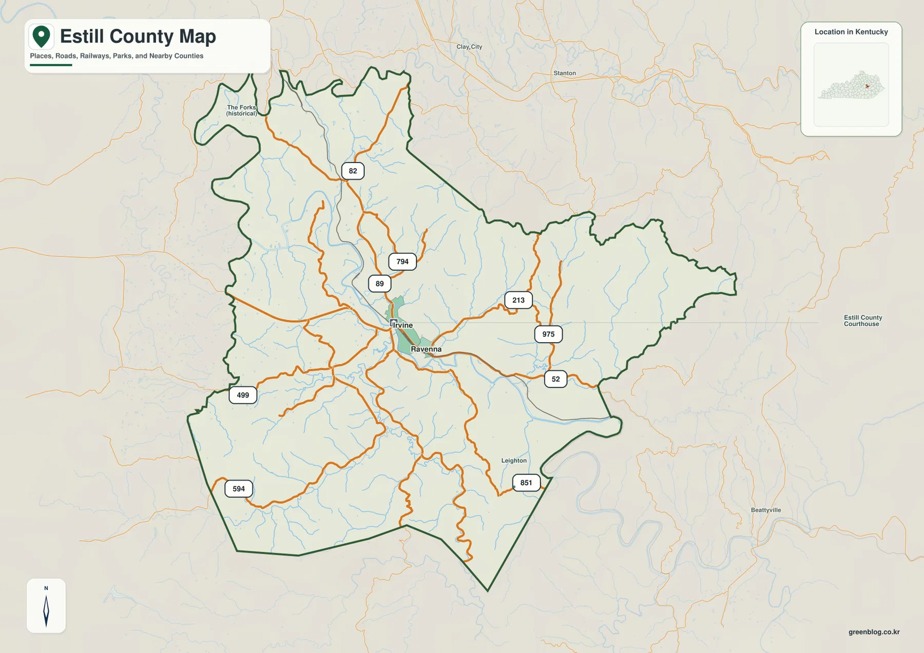
A useful way to orient yourself is to start with Irvine and Ravenna rather than with the county outline alone. Roads such as KY 52, KY 82, KY 89, KY 213, KY 499, KY 594, KY 851, and KY 975 spread from the central area into valleys that bend around the ridges. The result is a road pattern that looks very different from a flat county with straight section-line roads, and the water and elevation maps make the reason easy to see.
Table of Contents
Irvine and Ravenna give the county its clearest point of reference
On the county map, Irvine and Ravenna appear close together near the center of Estill County. Irvine is the more prominent road junction, with several numbered routes approaching the area, while Ravenna sits just to the southeast. Once those two names are located, the rest of the county is easier to divide into the northern valleys, the long eastern section, the southwestern uplands, and the southern ridges.
The map also labels smaller places such as The Forks in the northwest and Leighton toward the southeast. Those labels are useful because much of Estill County lies outside the two incorporated city centers. Neighboring counties shown around the map include Madison, Powell, Clark, Lee, Wolfe, Owsley, and Jackson, so the county can be placed within a broader part of eastern Kentucky without losing the local road detail.
Two cities are concentrated in one central valley area
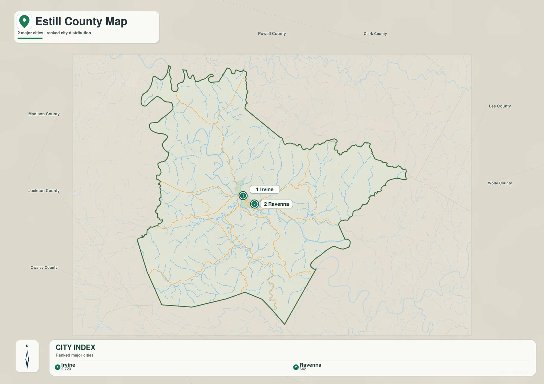
The city map ranks Irvine first and Ravenna second among the major cities shown for the county. Its index displays 2,723 for Irvine and 642 for Ravenna. Those figures are best treated as the map package’s city-reference values rather than as a substitute for a current Census estimate, but they help explain why Irvine is the strongest city label on the map.
What matters most visually is how close the two city markers are. Estill County does not show a chain of similarly sized towns spread from one edge to the other. Instead, Irvine and Ravenna form a compact central pair, while roads and small settlements extend outward along separate valleys. For a visitor using the map to locate an address area, trailhead, family-history site, or local destination, finding this central pair first gives a reliable starting point.
Roads follow the easiest passages through a ridge-and-valley landscape
The road network makes more sense when it is read alongside the terrain. KY 89 and KY 82 head north from the central area, while KY 52 continues east from near Ravenna. KY 213 and KY 975 serve the eastern interior, and KY 499 and KY 594 connect parts of the western and southwestern county. KY 851 appears near the southeastern side. These routes bend frequently because they are working through narrow valleys and around steep slopes rather than crossing a broad plain.
That pattern matters when estimating travel from a printed map. Two points may appear close in a straight line yet require a longer drive if a ridge separates their valleys. A road number, river crossing, and nearby creek name are often more useful local clues than compass direction alone. The map is therefore best used to trace a realistic route through the county rather than to assume that the shortest-looking line is the quickest connection.
The Kentucky River is the main water landmark, but the tributary network adds detail
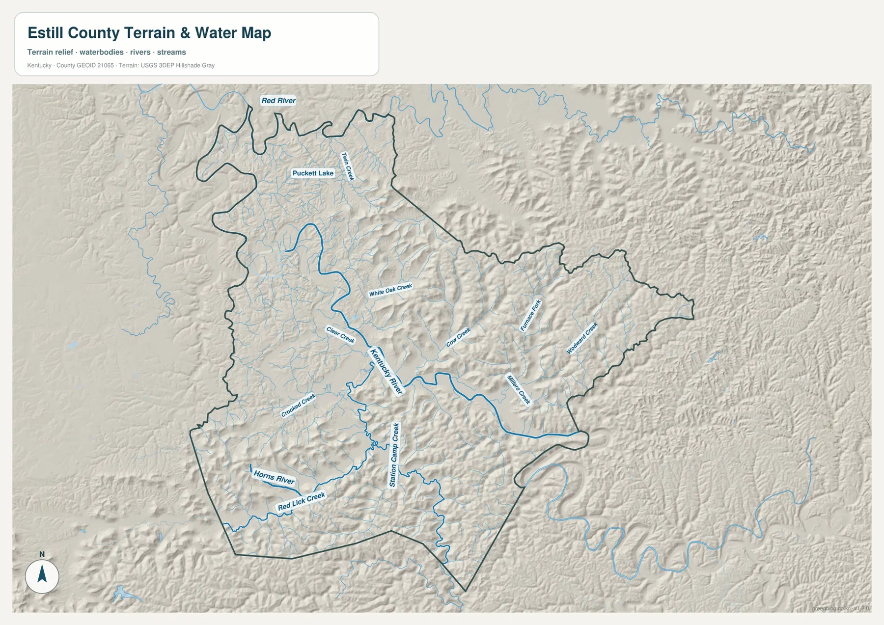
The terrain-and-water map gives the Kentucky River the strongest visual emphasis. It passes through the central part of the county and bends eastward, linking the Irvine-Ravenna area to a broader river corridor. The Red River appears along the northwestern side, while the Horns River is labeled in the southwest. Together, those larger waterways show that Estill County is divided among several drainage directions and valley systems.
Smaller named streams make the map especially useful for local orientation. White Oak Creek, Clear Creek, Crooked Creek, Cow Creek, Furnace Fork, Winding Creek, Station Camp Creek, and Red Lick Creek are all labeled. Twin Creek and Puckett Lake appear in the northwestern part of the map as well. These names can help connect a road or community location to the valley it occupies, which is often more meaningful here than simply saying a place is east or west of Irvine.
The water map should be treated as a geographic reference, not as a flood-risk or navigation product. It shows where waterways are represented in relation to terrain, but it does not provide flood zones, water depth, current stream conditions, or legal access. Those questions require current data from the appropriate public agency.
Elevation rises from river corridors into a tightly folded set of ridges
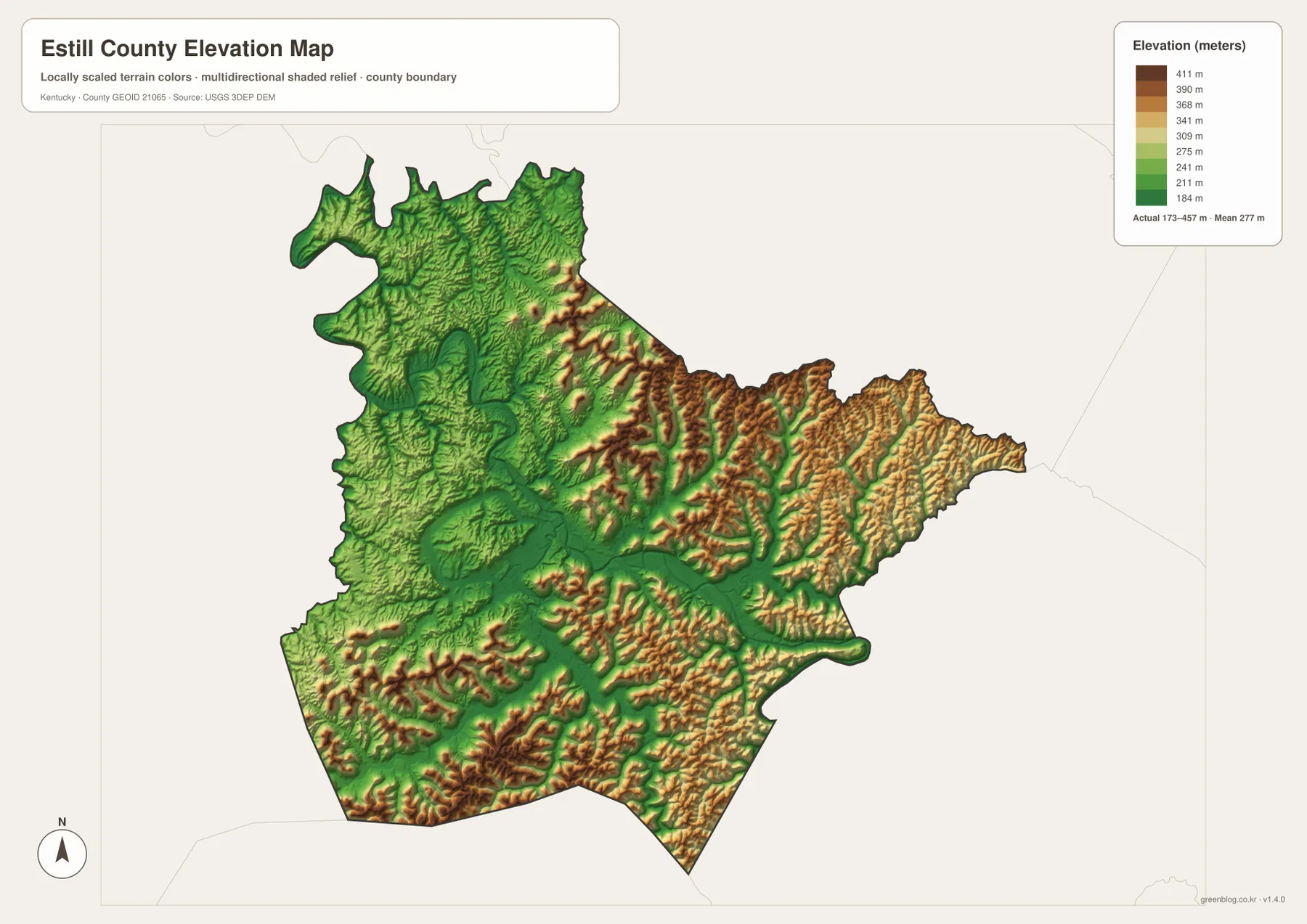
The elevation map reports an actual range of about 173 to 457 meters, with a mean elevation of 277 meters. Lower terrain appears along the Kentucky River and other valleys, while higher colors become much more common across the eastern and southern ridges. The contrast is strong enough that the county’s drainage pattern can be recognized even before individual creek labels are added.
Eastern Estill County is especially textured, with narrow ridge crests and branching valleys packed close together. The south and southwest also contain high ground, while the central river corridor forms a lower route through the county. This explains why the road network bends so often and why nearby valleys can feel separated despite being only a short distance apart on a county-wide map.
The elevation surface is designed for county-scale comparison rather than engineering or survey work. It is useful for seeing which parts of Estill County are relatively low or high and for relating roads and streams to the terrain. Exact property elevations, construction grades, and legal survey questions require more precise source data.
Reading roads and streams together makes local locations easier to understand
The maps become most informative when the layers are compared rather than viewed as isolated products. Around Irvine and Ravenna, several roads converge in the same broad valley area occupied by the Kentucky River and tributaries. Farther east, both roads and creeks branch into narrower corridors between ridges. That relationship explains why settlement and transportation appear concentrated in some valleys while nearby uplands remain less connected.
For the northern part of the county, KY 82, Twin Creek, and the Red River provide useful anchors. In the east, KY 52, KY 213, KY 975, Furnace Fork, and Winding Creek help distinguish one valley from another. Station Camp Creek is a useful feature in the south-central area, while KY 499 and KY 594 help organize the western side. Combining one road with one named waterway is often the quickest way to recognize a specific section of the county.
Choosing the map that fits the question
Use the county map when you need boundaries, roads, place names, and surrounding-county context on one page. The city map is cleaner when the main question is where Irvine and Ravenna sit relative to the county. The terrain-and-water map is better for named rivers, creeks, and the shape of the valleys, while the elevation map gives the clearest overview of which ridges are high and which river corridors are low.
The same distinction is useful for printing. A general local-information handout may work best with the county map, while a classroom discussion of drainage or landforms can pair the water and elevation maps. None of these files is intended to replace parcel records, professional surveying, flood-zone mapping, or live road-condition information. Their strength is county-scale orientation with clear labels and a consistent boundary.
The download contains the original high-resolution JPG versions of the four maps shown in the article. That gives you a larger source file than the web preview when you need to zoom in on labels or prepare a printed reference. Because every file emphasizes a different part of the same county, you can use one map by itself or compare several without having to reconstruct the geography from separate sources.
A practical way to remember Estill County on the map
Estill County is easiest to remember as a central Irvine-Ravenna valley surrounded by a dense network of ridges and tributaries. The Kentucky River provides the main water landmark, while the eastern and southern uplands give the county its strongest relief. Roads repeatedly return to the valleys because those corridors provide the most practical passages across a rugged landscape.
When using the maps, locate the county boundary first, then find Irvine and Ravenna, and finally trace the nearest road and creek toward your area of interest. That sequence works well in a county where many local places sit in narrow valleys that can look similar at first glance. For live road closures, current flood conditions, or legal property questions, use the latest agency information rather than relying on a static reference map.
Frequently Asked Questions
Where are Irvine and Ravenna on the Estill County maps?
Both cities are near the middle of the county and are shown very close to one another. Irvine is slightly northwest of Ravenna and functions as the stronger road-reference point, while Ravenna sits just to the southeast near the Kentucky River corridor. Finding those two labels first makes the surrounding road and creek network much easier to follow.
Why does the Kentucky River corridor appear lower on the elevation map?
River valleys occupy lower ground than the ridges that surround them. The Estill County elevation map shows an actual range of about 173–457 meters, and the Kentucky River corridor is part of the lower green terrain while higher ridges become more common to the east and south. The colors are intended for relative county-scale comparison.
Can these maps be used for flood zones or legal property boundaries?
No. These are general geographic reference maps. For flood risk, use current official flood maps and alerts; for parcel or legal-boundary questions, use county property records and professional survey information. The maps on this page are best for understanding roads, towns, waterways, and terrain at the county scale.
Map File Information
The ZIP contains the original high-resolution JPG files for the four Estill County maps described on this page.
- Included Files: county map, city map, terrain and water map, and elevation map
Related Maps
Sources and references
County boundary and geographic reference data can be checked through the U.S. Census Bureau TIGER/Line program. Kentucky local-government information for the county is available from the Kentucky Department for Local Government Estill County profile.
Water features can be referenced through USGS National Hydrography, and elevation information through the USGS 3D Elevation Program. For historical county-formation context, the Kentucky Department for Libraries and Archives County Formation Chart lists Estill County as formed in 1808 with Irvine as its county seat.
Green Map creates custom-edited map images using open geographic data sources such as geoBoundaries, Natural Earth, OpenStreetMap, and government open data. These maps are edited visual materials, not raw data files, and are provided for education, documents, presentations, and graphic reference.