Bell County occupies Kentucky’s southeastern corner, where Pineville and Middlesboro sit in very different Appalachian valleys surrounded by steep Cumberland Mountain ridges. US 25E provides the main connection between the two cities and continues toward Tennessee, while KY 66, KY 221, KY 119, KY 72, and other routes follow narrow stream corridors through the mountains. Unlike a county with broad plains, settlement and transportation here are concentrated on the limited low ground between ridges. High-resolution map files are available for download in the section below.
This guide follows Pineville, Middlesboro, the Cumberland River and major creeks, and terrain ranging from about 297 to 1,033 meters. WebP previews are available for quick viewing, and the matching high-resolution JPG files can be downloaded together in one ZIP for printing, classroom work, or offline reference.
Table of Contents
Pineville and Middlesboro occupy two very different mountain settings
Pineville sits in a narrow Cumberland River valley near the center-west of the county and serves as the county seat. The Bell County Clerk maintains its main office on Courthouse Square, and the map shows US 25E close to KY 66 and KY 221. Steep slopes rise quickly around the city, with Straight Creek country to the northeast and the long Pine Mountain ridge immediately to the south.
Middlesboro lies farther south in a much broader basin. US 25E crosses the city and connects with KY 74, KY 186, KY 132, and KY 90. The city also provides the Kentucky-side urban gateway to the Cumberland Gap area near the Tennessee and Virginia borders. The contrast between Pineville’s confined river valley and Middlesboro’s wider basin is one of the clearest patterns in Bell County.
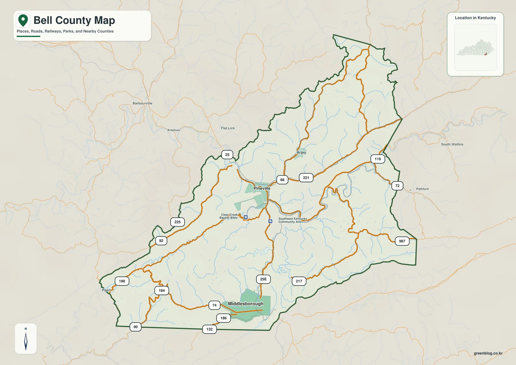
Arjay and the KY 119–KY 72 corridor connect the northeast toward Harlan County. KY 225, KY 92, and KY 190 follow western valleys toward Knox and Whitley counties, while KY 987 and KY 217 serve the southeastern mountain country. In Bell County, ridges and stream valleys often matter more to travel than straight-line distance.
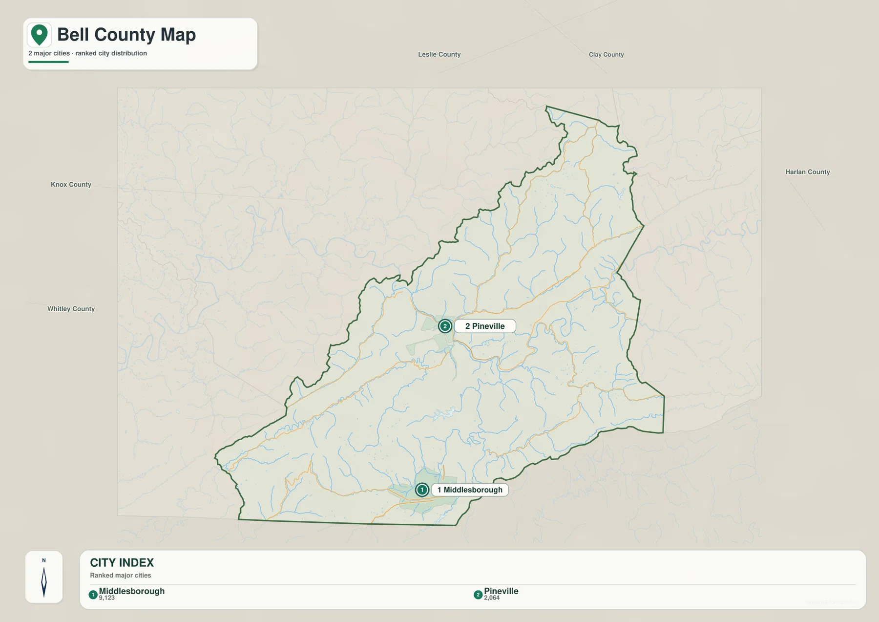
The city index places Middlesborough first and Pineville second
The supplied city panel ranks Middlesborough at 9,123 and Pineville at 2,064. These are map index values rather than current official population estimates. The map uses the Middlesborough spelling, while Middlesboro is now common in government and National Park Service usage; both forms refer to the same city in southern Bell County.
The settlement pattern is easier to understand through terrain than through ranking alone. Middlesboro occupies the large southern basin, while Pineville is squeezed into a much narrower Cumberland River corridor. Roads, river crossings, and mountain gaps therefore explain each city’s role better than city size by itself.
Middlesboro also serves as a major visitor gateway to Cumberland Gap National Historical Park. The National Park Service visitor facilities and park access near US 25E reinforce the city’s importance as a southern transportation and tourism center.
The Cumberland River and Straight Creek form the county’s strongest low corridors
The Cumberland River is the largest water feature on the map. It crosses the Pineville area through a narrow mountain valley and collects several tributaries where settlement and transportation have historically concentrated on the limited flat ground.
Straight Creek extends northeast from the Pineville side, with Left Fork Straight Creek draining the northern mountains. Greasy Creek and Clear Creek form western valleys, Little Clear Creek cuts the central-southern uplands, and Brownies Creek, Yellow Creek, and Cedar Creek divide the southeastern and southern ridges.
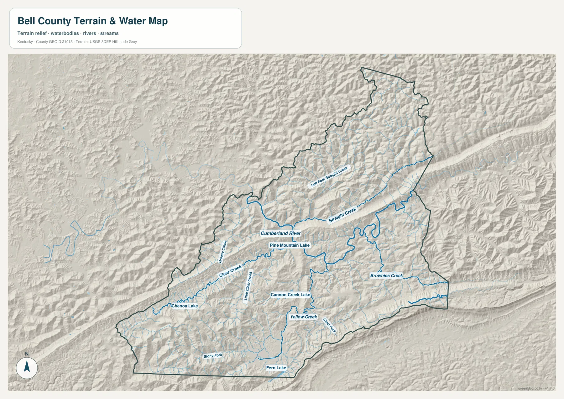
Pine Mountain Lake, Cannon Creek Lake, Chenowa Lake, and Fern Lake appear as smaller water references inside the mountain landscape. Stony Fork also provides a long southern-valley reference west of Middlesboro. The county is not dominated by one large reservoir; instead, its geography is organized by rivers and numerous narrow creek valleys.
This image is intended for geographic reference rather than floodplain, navigation, water-quality, parcel, or legal-access decisions. Stream and lake conditions can change, and current agency information should be used whenever safety, access, or property decisions depend on water conditions.
Elevation from 297 to 1,033 meters reveals a true Appalachian mountain county
The elevation surface ranges from about 297 to 1,033 meters, with a mean near 514 meters. More than 700 meters separate the lowest valleys from the highest ridges. Green lowlands follow the Cumberland River and major creeks, while tan and brown mountain crests surround the county on nearly every side.
Pine Mountain forms one of the most obvious long ridges. It crosses south of Pineville as a continuous elevated band, forcing roads and streams to use gaps, valleys, and lower crossings. Middlesboro sits in a much broader low basin south of the ridge, creating a striking contrast with the surrounding Cumberland Mountains.
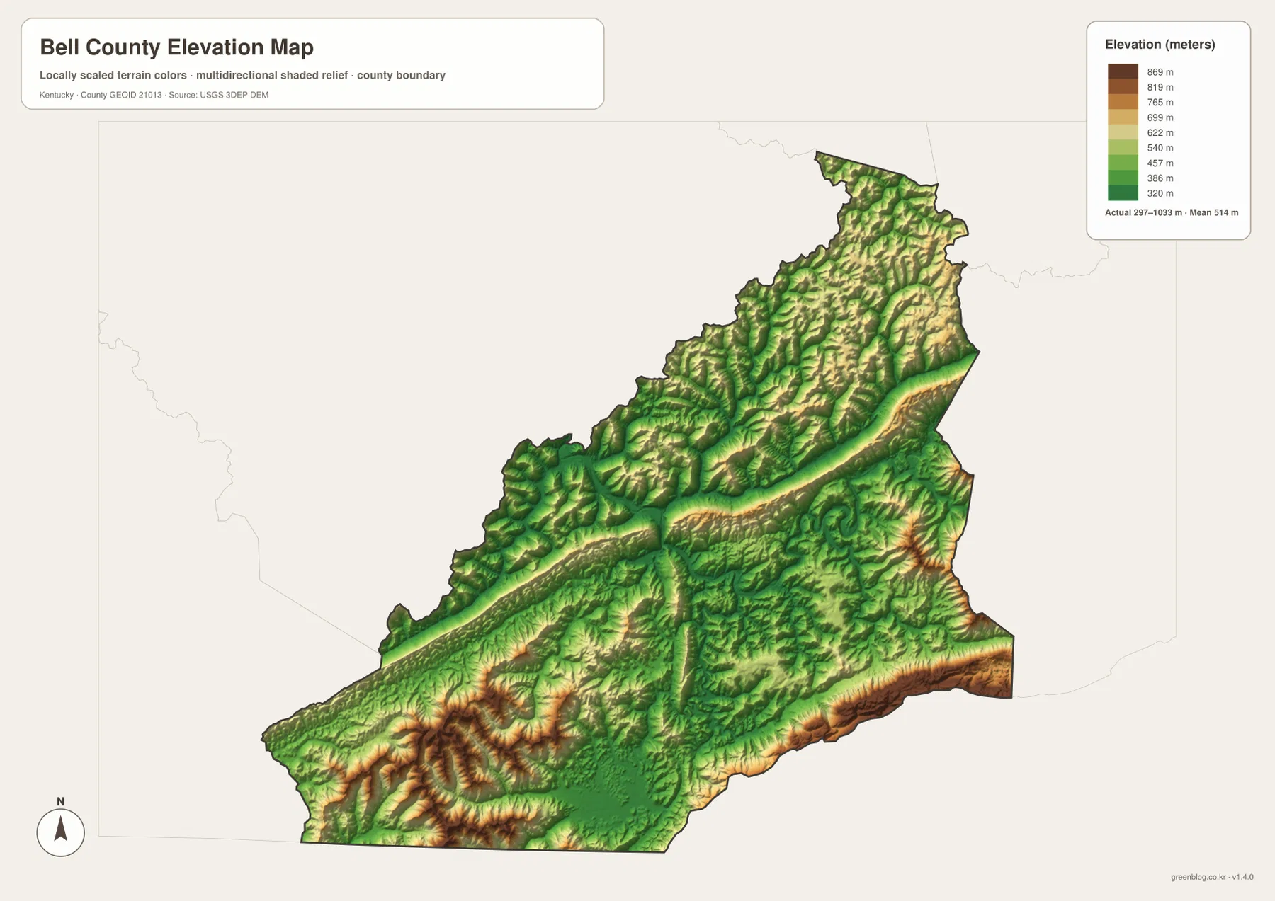
High terrain continues toward Harlan County and along the southeastern Virginia and Tennessee edges. The northern half contains many parallel tributary valleys separated by narrow ridges, while the western Cumberland River side is lower but still bordered by steep slopes. This relief explains why Bell County roads often follow winding valleys rather than direct lines.
The elevation surface is generalized for county-scale comparison. It is not survey-grade or engineering-grade measurement and should not be used for parcel elevations, construction, mining, drainage design, or legal boundary work.
Cumberland Gap shows why mountain passes shaped Bell County travel and settlement
The National Park Service describes Cumberland Gap as a mountain passage used by people and animals for thousands of years. Daniel Boone helped blaze the Wilderness Road through the gap in 1775, and the route later carried hundreds of thousands of settlers westward across the Appalachians.
Bell County’s southern US 25E corridor brings modern travelers close to this same passage near Middlesboro. Pineville has its own connection to the old route at Cumberland Ford, which the Kentucky Historical Society identifies as an important Wilderness Road crossing. Long before modern highways, gaps and river fords determined where people could move through this rugged county.
Pine Mountain State Resort Park and Chained Rock rise directly above Pineville
Kentucky State Parks records that Bell County residents assembled about 2,000 acres in 1925 and donated the land to the Commonwealth for what became one of Kentucky’s first state parks. Originally called Cumberland State Park, it was later renamed Pine Mountain State Park and is now Pine Mountain State Resort Park.
The park’s Chain Rock Trail leads to Chained Rock above Pineville. Kentucky State Parks notes that the rock was chained to an adjacent cliff in 1933, tied to local folklore that it might otherwise fall toward town. The viewpoint looks across Pineville, present-day US 25E, Pine Mountain, and the surrounding mountain landscape.
That view closely matches the relief map: Pineville occupies a narrow low area with steep ridges immediately above it. Chained Rock is therefore not only a local landmark but also a useful place for understanding how tightly the county seat is fitted into the mountain terrain.
Middlesboro combines a meteorite-impact basin with a mining-era city story
The Kentucky Historical Society identifies Middlesboro as one of the few North American cities built within a meteorite-impact structure. The roughly three-mile basin creates the unusually broad low area visible around the city and helps explain why the southern urban district has more room than the narrow Pineville valley.
Another Kentucky historical marker records that Middlesborough was developed beginning in the 1880s through a British-backed project led by Alexander Arthur. Coal, iron, railroad construction, and the Cumberland Gap tunnel shaped the city’s early growth. The map’s broad southern basin and major transportation routes make that industrial history easier to understand.
Travel from Pineville to Middlesboro moves from a confined river valley into a broad basin
Southbound travel on US 25E leaves Pineville through terrain constrained by the Cumberland River and steep mountainsides. After crossing the Pine Mountain corridor, the landscape opens dramatically near Middlesboro, where a larger urban area occupies the lower basin.
Travel in the opposite directions from Pineville on KY 66, KY 221, and KY 119 stays within narrower Straight Creek and tributary valleys. High ridges remain close to the road, and routes bend with the drainage network. In Bell County, rivers, creeks, gaps, and ridges are essential for understanding how places connect.
For posters, classroom prints, or presentation slides, use the original JPG files in the download archive rather than enlarging the web previews. Small route labels, creek names, ridge colors, and the elevation legend remain clearer at the higher resolution.
Frequently Asked Questions
Why do the map and some current sources use Middlesborough and Middlesboro differently?
The supplied city index uses Middlesborough and gives it a map index value of 9,123. Current government and National Park Service materials commonly use Middlesboro. The names refer to the same southern Bell County city, and the 9,123 figure should not be treated as a current official population estimate.
Why is Cumberland Gap important to the Bell County map?
Cumberland Gap is the historic mountain passage near Middlesboro where the Wilderness Road crossed the Cumberland Mountains. It explains why this southern corridor became a major route through otherwise high, rugged terrain and remains one of the county’s strongest geographic and historical landmarks.
Can the 297–1,033 meter elevation image be used for surveying or engineering?
No. It is a generalized county-scale terrain image for comparing low Cumberland River and creek valleys with high Pine Mountain and Cumberland Mountain ridges. Parcel elevations, engineering grades, mine planning, drainage design, and legal boundary work require more precise official data and professional analysis.
Map File Information
The archive contains the Bell County, Kentucky general county map, city map, terrain-and-water map, and elevation map as original high-resolution JPG files.
- Included Files: Use only the versions confirmed in the article and supplied images
- File Type: Use the confirmed download contents
- Intended Use: Printing, education, presentations, and map-based projects
Related Maps
Sources and references
- Bell County Clerk — county administration locations in Pineville and Middlesboro
- National Park Service: Cumberland Gap National Historical Park — park geography, history, and Middlesboro visitor information
- National Park Service: Cumberland Gap — formation of the gap and Wilderness Road history
- Kentucky State Parks: Our History — origins of Pine Mountain State Resort Park
- Kentucky State Parks: Chain Rock Trail — Chained Rock and the Pineville overlook
- Kentucky Historical Society: Middlesboro Meteorite Crater Impact Site — the city’s meteorite-impact basin
Green Map creates custom-edited map images using open geographic data sources such as geoBoundaries, Natural Earth, OpenStreetMap, and government open data. These maps are edited visual materials, not raw data files, and are provided for education, documents, presentations, and graphic reference.