Wilcox County in south-central Georgia does not read as a single-cover landscape. Agriculture is the largest 2025 class at 33.04%, but forest still covers 27.38% and wetlands 20.92%. Those three classes overlap in a patchwork that changes noticeably from the broad farm blocks in the west and south to wetter, more wooded land along the eastern side. This Wilcox County Georgia Land Cover Map is designed to make those contrasts easy to compare.
The page uses four views: current land cover, forest and farmland, impervious surface and developed land, and a 1985–2025 class-difference map. The WebP images are shown with the explanation, while the four original 2480 × 1754-pixel JPG files are available together in one ZIP download below. They work well for county profiles, classroom materials, presentations, and broad landscape comparison.
Table of Contents
A farm-dominated county still contains large wooded and wet areas
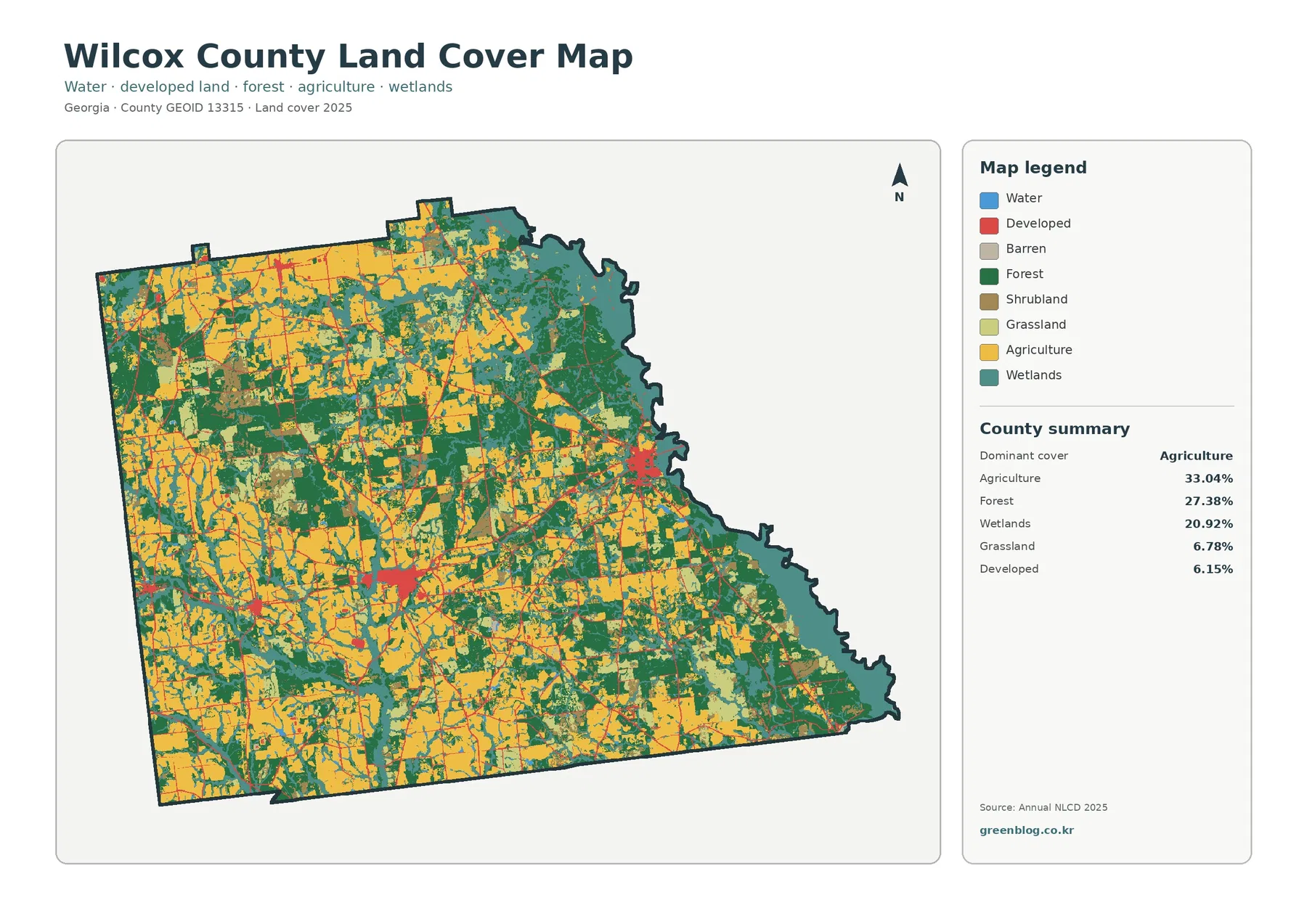
Agriculture accounts for 33.04% of the supplied 2025 summary. Large yellow blocks are common across the western half, the southwest, and parts of the central county, but they are repeatedly broken by forest, grassland, wetlands, and developed strips. The result is not one continuous agricultural plain. Instead, fields are interwoven with natural cover and narrow corridors that make the county look different from one section to another.
Forest is the second-largest class at 27.38%. The largest wooded concentrations appear toward the northeast and along portions of the eastern edge, with additional blocks scattered among farm areas elsewhere. Wetlands add another 20.92%, so forest and wet ground together cover nearly half of the county in the supplied classification. That is why the eastern half looks substantially greener and more teal than the broad agricultural sections farther west.
The Ocmulgee side is visibly wetter than much of the western interior
The county’s eastern boundary follows the Ocmulgee River, and USGS maintains a monitoring location on the river at Abbeville. On the land-cover image, wetland colors trace long, irregular areas close to that eastern boundary and continue inland along branching low areas. The map does not identify flood zones or regulatory wetlands, but the river reference helps explain why the eastern edge deserves separate attention when comparing countywide land-cover patterns.
Moving west from the river side, agriculture becomes more frequent and often forms larger blocks. Forest remains important, but it is broken into a more mixed pattern with fields, grass, shrub cover, and smaller wetland strips. The 33.04% agriculture figure is therefore a countywide average, not a description of every local area. A river-edge location can look very different from a farm-centered location only a few miles away.
Forest and farmland form a working mosaic rather than two separate zones
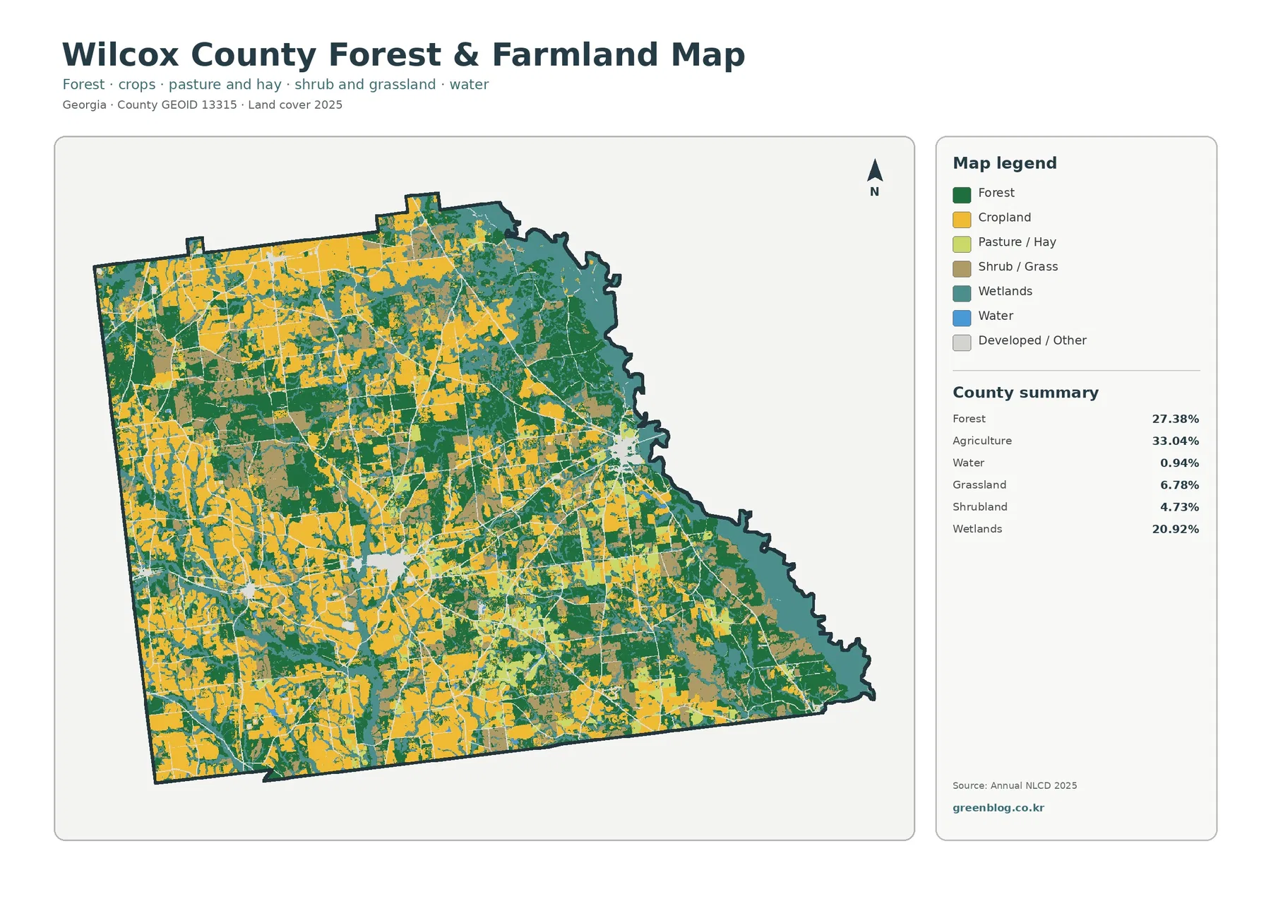
The forest-and-farmland view removes some of the visual competition from the full legend and makes the working-land pattern easier to follow. Agriculture remains the largest single class, but wooded blocks divide many of the larger farm areas. The strongest forest concentrations lie in the eastern and northeastern parts of the county, while the west and southwest show more frequent cropland patches. This balance makes the map useful for explaining why Wilcox County cannot be summarized as either simply agricultural or simply forested.
Grassland represents 6.78%, shrubland 4.73%, and open water 0.94% in the supplied summary. Those smaller classes still matter. Grass and shrub cover often appear near the margins of farm and forest blocks, while open water is limited in total area but helps anchor the river and drainage context. A land-cover class should not be confused with ownership, zoning, farm boundaries, or a legal land-use designation; it describes the surface condition assigned to a raster cell for the observation year.
Built surfaces are concentrated in small centers instead of spread evenly
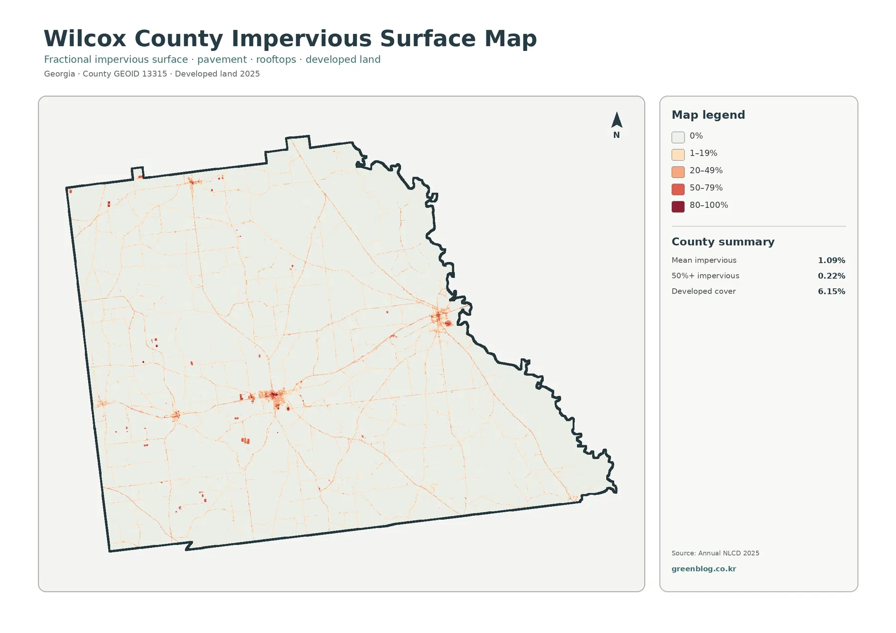
Developed land accounts for 6.15% of the 2025 land-cover summary, while mean impervious cover is only 1.09%. Impervious surfaces are hard surfaces such as pavement, rooftops, and parking areas where water does not readily soak into the ground. Most of the county stays in the lowest impervious categories, which fits the broad agricultural, forested, and wetland landscape seen in the other maps.
The strongest built cluster on the eastern side broadly matches the Abbeville area, while another clear concentration in the interior is consistent with the Rochelle area. Smaller concentrations also appear in the general areas of Pitts and Pineview. Georgia Department of Revenue records list Abbeville, Pineview, Pitts, and Rochelle within Wilcox County, but the image itself does not draw municipal boundaries. These place names are therefore useful geographic context, not a substitute for an incorporated-place layer.
Only 0.22% of the county is summarized as having 50% or greater impervious cover. That figure is far below the 6.15% developed-land share because a developed class can contain lawns, trees, bare ground, drainage areas, and other permeable surfaces in addition to buildings and pavement. The two measures answer different questions: developed cover describes a broader land-cover category, while impervious percentage isolates the hard-surface component.
Abbeville, Rochelle, Pitts, and Pineview provide useful location context
The maps do not print town names, so readers should avoid assigning every colored patch to a municipality. Official Georgia sources identify Abbeville, Pineview, Pitts, and Rochelle as the incorporated places associated with Wilcox County, and the state’s community-planning page groups those four cities with the county. Using that information alongside the maps helps orient the major developed clusters without pretending that the land-cover image contains city limits.
Abbeville is especially useful as an eastern reference because USGS identifies an Ocmulgee River monitoring station there. Rochelle provides a central-to-western reference for the larger interior built cluster, while Pitts and Pineview help explain smaller concentrations farther west and north. The surrounding landscape quickly returns to agriculture, forest, wetlands, and grassland outside those centers, which is why the impervious map looks sparse even though several communities are present.
The 1985–2025 comparison marks a 30.25% class difference
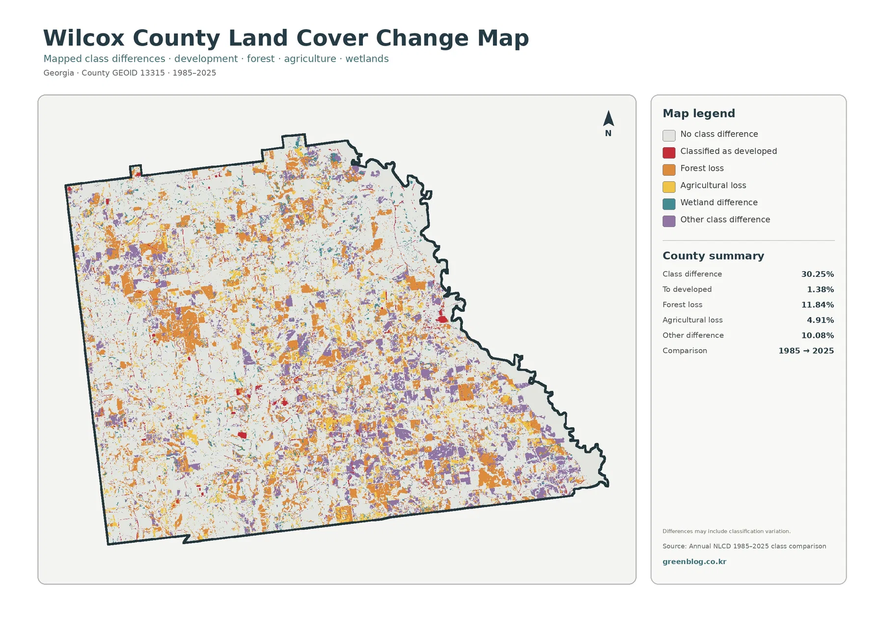
The supplied endpoint comparison reports a total class difference of 30.25% between 1985 and 2025. Forest loss is the largest listed category at 11.84%. Agricultural loss accounts for 4.91%, cells classified as developed account for 1.38%, and other class difference accounts for 10.08%. Wetland difference is also mapped, although the summary panel does not print a separate percentage for that category.
Change colors are scattered across the county rather than confined to one town. Larger orange and purple patches appear in several western, central, and southeastern areas, while smaller marks are widespread elsewhere. That distribution makes the comparison useful for finding places that deserve a closer look, but it does not establish the timing or cause of a change. The map itself warns that classification variation can be included in the difference layer.
Forest-loss colors do not mean that the county has lost all of its forest
Forest remains 27.38% of the 2025 map, so the 11.84% forest-loss figure must be read as an endpoint transition category, not as a statement that current forest has largely disappeared. A cell classified as forest in 1985 may have a different 2025 class, but the map does not show every condition that occurred during the forty years in between. A site could have been harvested, replanted, developed, farmed, flooded, or reclassified more than once.
For the same reason, forest-loss patches near agriculture should not automatically be described as agricultural expansion. The image only supports a spatial association. Explaining cause requires intermediate aerial photographs, land-management records, development records, or other local evidence. The most defensible use of this layer is to identify broad areas of endpoint difference and then investigate those areas with more detailed sources.
Agriculture is important enough to justify a separate local-source check
University of Georgia Cooperative Extension operates a Wilcox County office in Rochelle and provides local programs related to agriculture and the environment. Its county impact materials discuss agricultural and natural-resource work, which gives useful local context for a map where agriculture is the largest single 2025 land-cover class. The land-cover image itself does not identify crop species, farm ownership, field boundaries, or annual planting decisions.
That distinction matters when the yellow agricultural class is used in a report. It is appropriate to say that agriculture is widely distributed and especially common in western and southern sections of the county. It is not appropriate to infer a specific crop or farm operation from color alone. Crop-specific questions should be checked against Extension resources, agricultural statistics, or field-level data that were designed for that purpose.
Thirty-meter raster cells are useful for county patterns, not parcel decisions
Annual NLCD is a raster product, meaning the landscape is divided into a grid of cells and each cell receives a predominant classification. The product is commonly distributed at 30-meter resolution. A single cell can contain trees, a road edge, a drainage ditch, grass, a building, and cultivated ground, yet it still receives one main class. Thin features can therefore look simplified or appear wider or narrower than they are on the ground.
Enlarging the JPG does not recover detail that is absent from the underlying grid. These maps are appropriate for county profiles, environmental education, broad watershed discussion, landscape comparison, and presentation graphics. They are not substitutes for a survey, parcel map, zoning map, wetland-jurisdiction determination, engineering drawing, or current site inspection. Decisions about a specific property require newer and more detailed sources.
A practical reading order keeps current cover separate from endpoint change
Start with the general 2025 map to establish the balance among agriculture, forest, wetlands, developed land, grassland, and other mapped classes. Then use the forest-and-farmland image to compare working land with wooded and wet areas. If the question is about settlement or transportation surfaces, move to the impervious map, where the compact concentrations around the main community areas are much easier to see.
Use the 1985–2025 layer last. Its colors represent differences between two classifications, not current surface classes, so showing it after the current maps reduces the chance that viewers will mistake an orange forest-loss patch or purple other-difference patch for a present-day land-cover category. This order also makes it easier to explain why a location can be currently forested even when nearby cells show historical class differences.
Choose one map for the main question and add another only when needed
For an agriculture lesson, the forest-and-farmland map is usually the clearest starting point because it highlights fields, forest, grass, shrub cover, wetlands, and water without emphasizing urban surfaces. For a county overview, the general map is better because it preserves the complete class mix. A planning-context presentation may benefit from the impervious view, while a long-term comparison should use the change layer as a follow-up rather than as the opening image.
Keeping each map at a readable size is more useful than squeezing all four into a single small panel. The original JPG files measure 2480 × 1754 pixels each. They are suitable for screens, reports, many classroom layouts, and ordinary presentations, but the package does not identify them as meeting an A3 high-resolution reference. Large-format printing should therefore be tested before final production.
The download contains the four original JPG maps used for this article
One ZIP includes the current land-cover map, forest-and-farmland map, impervious-surface and developed-land map, and 1985–2025 class-difference map. Keeping the original JPGs together makes it easy to use the countywide overview first and then add the more specialized image that supports the topic being discussed.
Frequently Asked Questions
What is the largest land-cover class in Wilcox County?
Agriculture is the largest class in the supplied 2025 summary at 33.04%. Forest follows at 27.38% and wetlands at 20.92%. The map shows broad farm areas in the west and south, while the eastern side contains more extensive forest and wetland cover.
Why is developed land 6.15% when mean impervious cover is only 1.09%?
Developed land is a broad class that can include lawns, trees, bare soil, drainage areas, and other permeable surfaces around buildings and roads. Impervious cover isolates hard surfaces such as rooftops and pavement. Because the measures describe different things, the countywide impervious average can be much lower.
Does the 30.25% class difference mean that 30.25% of Wilcox County was developed?
No. Cells classified as developed account for 1.38% in the supplied change summary. The 30.25% total also includes forest loss, agricultural loss, wetland difference, other class difference, and possible classification variation. Additional imagery and records are needed to determine when and why a particular location changed.
Sources and Reference Data
- MRLC Annual NLCD Data – official access point for annual land-cover and change products
- USGS Annual NLCD Land Cover Classification – definitions for forest, agriculture, wetlands, developed land, and other classes
- USGS Ocmulgee River at Abbeville – official river monitoring location in Wilcox County
- UGA Cooperative Extension – Wilcox County – local agriculture and environmental resources
- Georgia DCA Wilcox County Comprehensive Plan – official planning resources for Wilcox County, Abbeville, Pineview, Pitts, and Rochelle
Map File Information
The ZIP contains four original JPG maps for comparing Wilcox County's 2025 land cover, forest and farmland, impervious surfaces and developed land, and 1985–2025 class differences.
- Included Files: Use only the versions confirmed in the article and supplied images
- File Type: Use the confirmed download contents
- Intended Use: Printing, education, presentations, and map-based projects
Related Maps
- Appling County Georgia Land Cover Map
- Atkinson County Georgia Land Cover Map
- Bacon County Georgia Land Cover Map
Green Map creates custom-edited map images using open geographic data sources such as geoBoundaries, Natural Earth, OpenStreetMap, and government open data.
These maps are edited visual materials, not raw data files, and are provided for education, documents, presentations, and graphic reference.