Clark County sits in southwestern Kansas, where Ashland, Minneola, and Englewood provide three useful anchors for reading a large rural landscape. Minneola is near the northwestern side, Ashland lies farther south near the middle of the county, and Englewood is in the southwest. The supplied maps separate roads and place names from city connections, waterways, and elevation so that each pattern remains readable. High-resolution JPG originals corresponding to the web maps can be downloaded together from the map file box below.
The county is not simply a flat plain. The elevation map reports an actual range of about 529 to 794 meters, with a mean near 658 meters. Higher terrain is concentrated across much of the northwestern and northern area, while lower greens become more extensive toward the southeast and along the Cimarron River corridor. Bluff Creek, West Branch Bear Creek, Big Sandy Creek, Little Sandy Creek, Day Creek, and other tributaries cut through that relief and create a much more varied surface than the general road map alone suggests.
Regional context helps explain the pattern. The Kansas Historical Society places Clark County in the Southwest region and identifies both the Red Hills and High Plains as important physiographic settings. It also describes Big Basin, gypsum-related landforms, cattle-drive history, rail development, and the severe Dust Bowl years. This article does not attempt to cover all of that history; instead, it uses the supplied maps to connect the county’s settlements, transportation references, drainage lines, and relief.
Table of Contents
Using Ashland and Minneola to Orient the County
Ashland is the most useful central reference on the general county map. It appears a little south of the county’s middle, where several numbered routes converge, while Minneola lies near the northwestern side. Englewood is much farther southwest, so the three communities reveal the scale of the county immediately. Lexington appears toward the east, and Bucklin is labeled beyond the northern side, helping distinguish places inside the boundary from useful neighboring references.
The road pattern provides a second layer of orientation. U.S. 54 is visible near Minneola in the north, while route numbers including 160, 183, and 283 help identify the Ashland and southern portions of the county. A driver can see why Ashland functions as a convenient map anchor: roads spread east, west, north, and south from its vicinity. The map is not a live navigation product, however, so current closures, construction, and road conditions should be checked separately before travel.
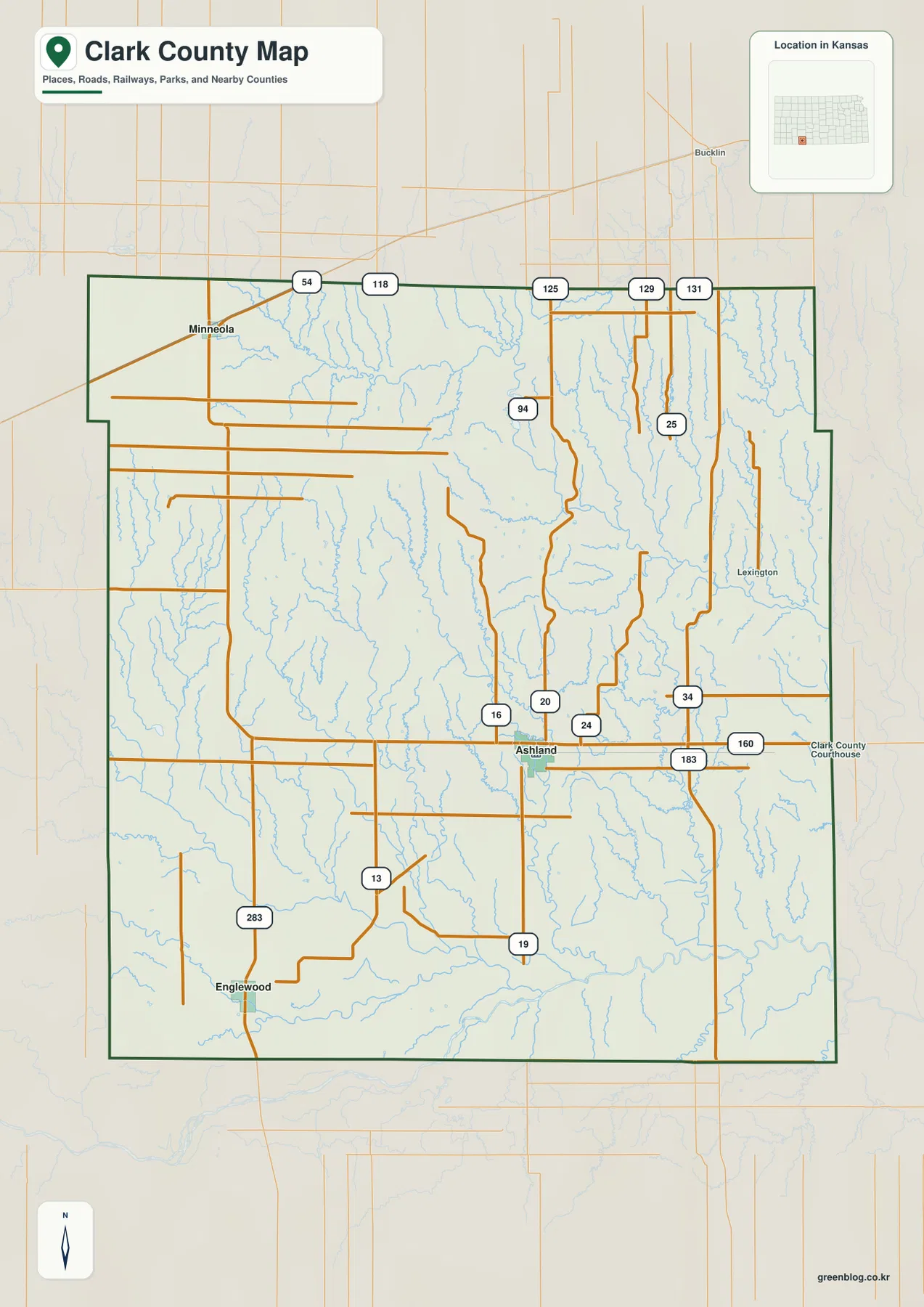
The general map is intentionally dense because it keeps settlements, roads, streams, and the county outline in one view. That makes it excellent for overall orientation but less efficient for following a small creek or comparing relief. After locating Ashland and Minneola here, the water and elevation maps make the same landscape easier to interpret by removing much of the transportation detail and emphasizing natural features.
Straight-Line Connections among Minneola, Ashland, and Englewood
The city-connections map uses Minneola as the hub and simplifies the county to three principal labeled communities. Ashland is shown about 22 miles from Minneola, while Englewood is about 27 miles away. These are direct straight-line distances, not driving distances measured along roads. Actual travel will be longer or shorter depending on route choice, road access, and current conditions, so the numbers are best used for geographic comparison rather than trip timing.
The three places form an easy mental framework for the rest of the page. Minneola is northwest, Ashland is southeast of Minneola and closer to the county’s central-southern area, and Englewood lies farther southwest. Once those positions are familiar, the general map can restore route numbers and smaller labels, while the terrain maps show why the land between the communities contains so many drainage cuts and elevation changes.
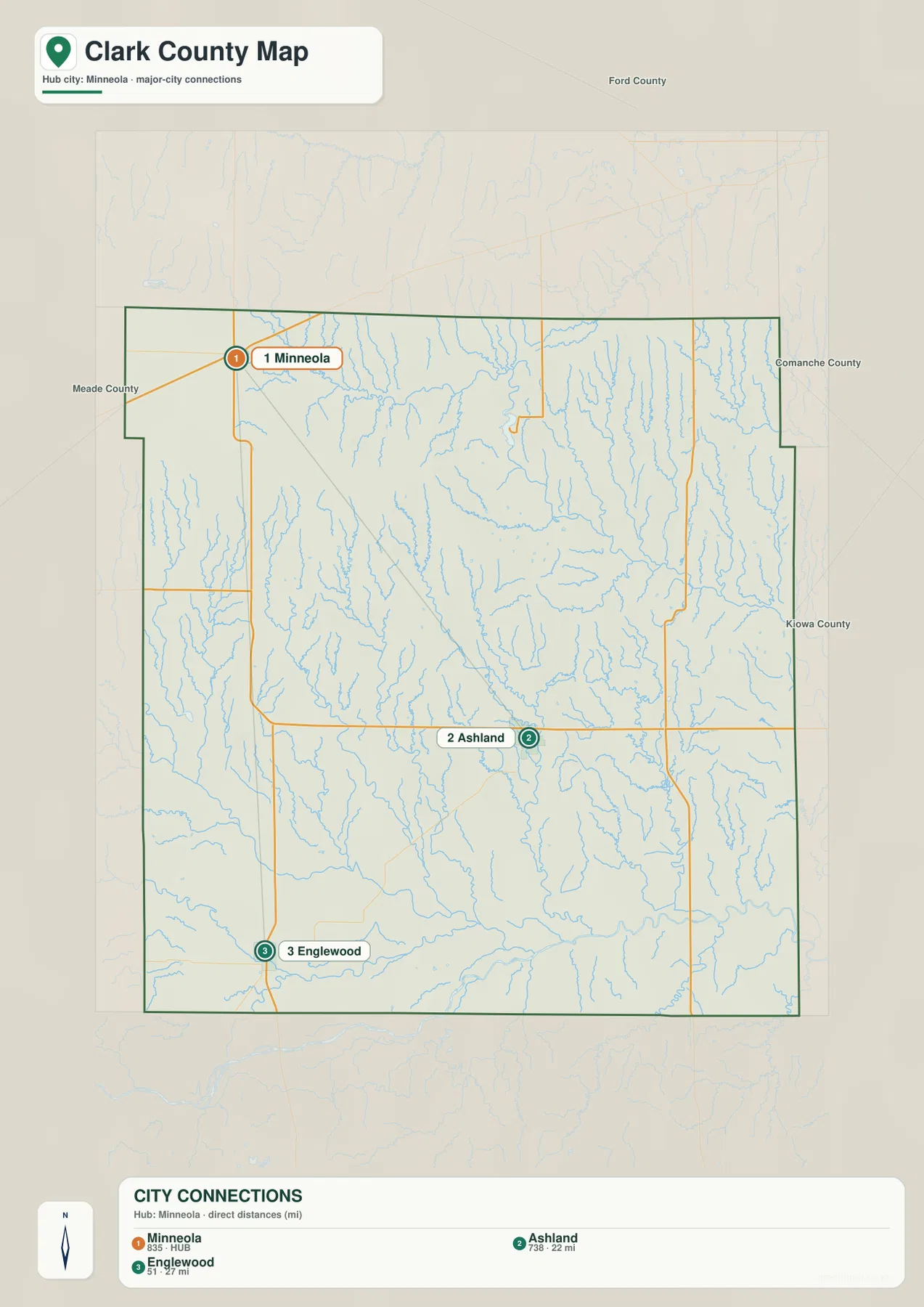
The ranked values on the map should be treated as part of the supplied cartographic product rather than a substitute for the latest population estimates. Anyone needing current demographic figures should consult a current Census release. For this map page, the important information is spatial: the communities are widely separated, and their positions provide convenient anchors for comparing road corridors, creek systems, and changes in elevation.
Cimarron River and the Creek Network across Southern Clark County
The terrain-and-water map makes the Cimarron River the strongest hydrologic reference. It follows the southern part of the county and receives drainage from numerous creeks descending from higher ground. Big Sandy Creek and Little Sandy Creek are prominent in the southwest, while Antelope Creek and Bullard Creek add smaller named channels in the same broad area. Proffitt Lake is also labeled in the west, providing a compact water-body reference among the branching stream lines.
Farther north and east, the map changes character. West Branch Bear Creek runs through the central portion, and Bluff Creek stretches across the northern area. Day Creek is a strong feature in the east, with Spring Creek and Bear Creek appearing nearby. Each named channel is surrounded by many shorter tributaries, so the drainage network is far denser than the handful of labels might imply. Some streams may be intermittent or highly seasonal; the map indicates mapped watercourses rather than current flow conditions.
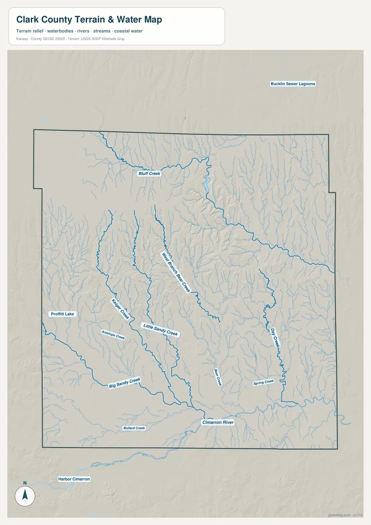
The water map should not be used as a real-time flood, navigation, or property-access map. A blue line confirms the mapped location of a stream or drainage feature, not whether water is currently flowing, how deep it is, or whether a crossing is safe. Its best use here is geographic: following creek valleys, recognizing how several drainage systems reach the Cimarron River, and matching those low corridors with the elevation map.
Elevation from 529 to 794 Meters: High Ground to the Northwest, Lower Terrain to the Southeast
The elevation layer reports a county range of roughly 529 to 794 meters and a mean near 658 meters. The broadest high areas are concentrated toward the northwest and north, where brown and orange tones dominate. Greens become more common toward the southeast and along lower drainage corridors. The resulting spread of about 265 meters is large enough to create pronounced ridges and valleys within a county that might otherwise be described simply as part of the western plains.
The most visually striking relief appears where streams cut into the higher northern terrain. Narrow green valleys divide orange and brown uplands, especially in the north-central portion. Moving southward, the terrain becomes generally lower, although smaller ridges and drainage cuts remain visible throughout the county. The lower Cimarron corridor and southeastern areas contrast strongly with the broad high ground nearer the northwest.
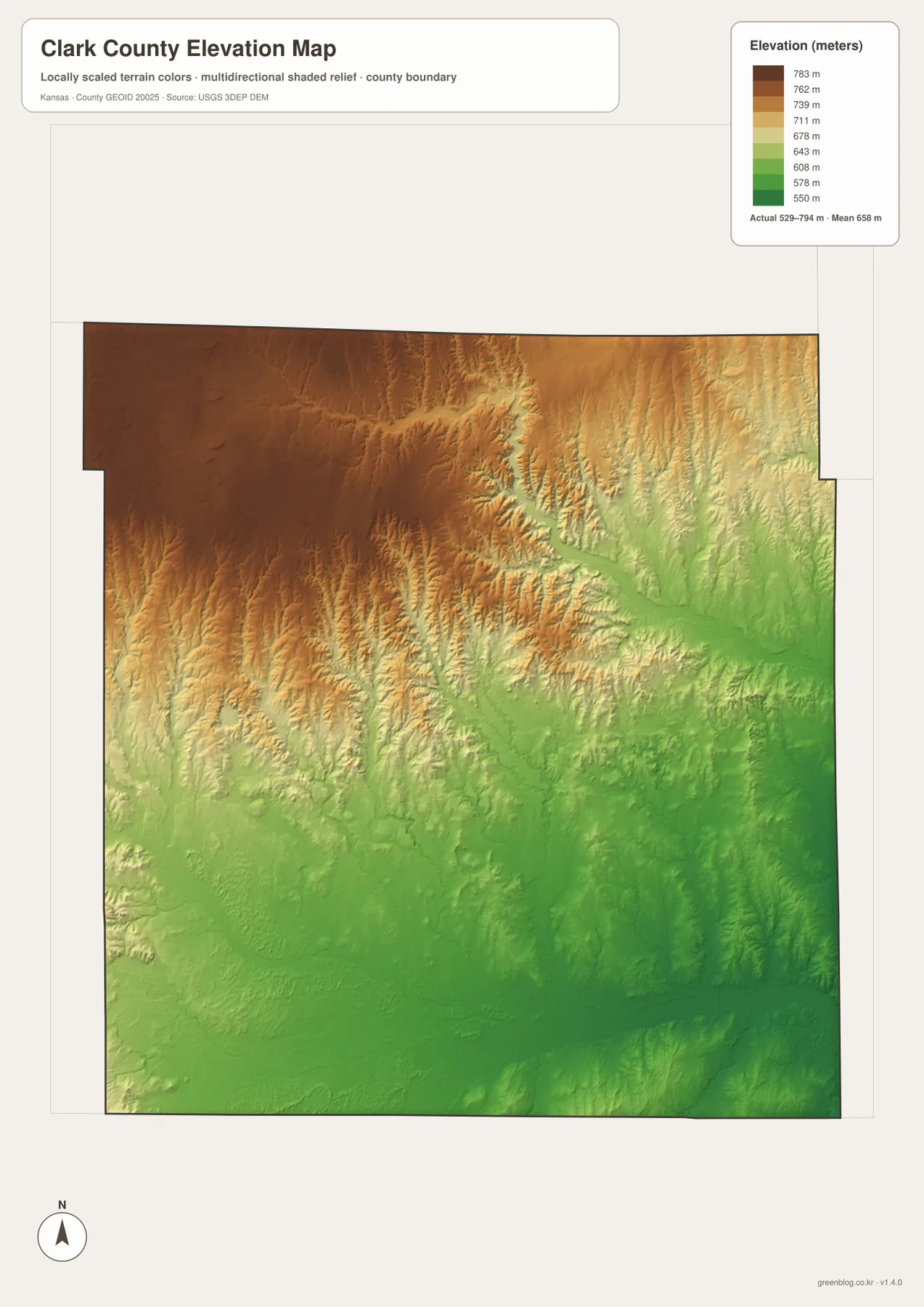
This generalized elevation surface is designed for county-wide comparison rather than parcel-level measurement. The colors and shaded relief help reveal ridges and valleys, but they do not replace a professional survey or engineering-grade elevation model. For construction, drainage design, or precise property work, the underlying USGS elevation data or a qualified survey should be consulted. On this page, the map is most useful for comparing the high ground near Minneola with lower areas toward Ashland, the Cimarron River, and the southeast.
Reading Roads and Drainage Together around Ashland
Ashland works particularly well as a cross-map reference because it appears clearly on the general map and sits near several route junctions. From that point, readers can trace roads east and west before switching to the water layer to see nearby tributaries running toward the Cimarron system. On the elevation map, Ashland occupies lower terrain than the broad northwestern uplands, and the land continues to fall toward parts of the southern drainage corridor.
Minneola provides the opposite perspective. Its northwestern position places it closer to some of the higher terrain, so comparing Minneola with Ashland makes the elevation gradient easier to remember. Englewood is useful for reading the southwestern part of the county, where road connections, Sandy Creek tributaries, and lower southern terrain overlap. Anchoring the natural features to recognizable place names is often more useful than memorizing a long list of elevations or creek names.
For actual travel, the maps should be paired with up-to-date road and weather information. Southwestern Kansas can experience strong winds, storms, and changing road conditions, and small roads or low-water crossings may not match a static map at every moment. These files are intended for geographic orientation and general reference, not live routing or emergency decision-making.
Red Hills, High Plains, and the Big Basin Background
The Kansas Historical Society describes Clark County as part of both the Red Hills and High Plains physiographic regions. That context fits the supplied elevation map, which shows broad high surfaces interrupted by deeply incised valleys rather than a uniformly level plain. The same historical profile highlights gypsum-related landforms, natural bridges, caves, and the distinctive Big Basin, all of which contribute to the county’s reputation for unusually rugged scenery in southwestern Kansas.
Big Basin is described as a large sinkhole created by the dissolution and collapse of underground gypsum and salt formations. St. Jacob’s Well is another well-known feature associated with the area. These named geologic sites are not all plotted on the supplied map set, so the maps should not be used to pinpoint their exact boundaries. They are nevertheless useful context for understanding why the terrain contains abrupt depressions, ridges, and drainage channels.
Human history is equally connected to the landscape. Ashland became the county seat, cattle drives crossed the region, rail service supported freight and ranching, and agriculture remained important through periods of drought. The county was heavily affected by the Dust Bowl, when dry soils and strong winds caused severe erosion. Knowing this background makes the wide spacing of settlements, extensive rural road network, and open agricultural land more meaningful when reading the maps today.
Working with the High-Resolution JPG Map Files
The web previews are convenient for seeing the overall pattern, while the original JPG files preserve more detail for enlargement and printing. Each original is 3638 by 2572 pixels, making small route numbers, short creek labels, and shaded-relief details easier to inspect. The archive corresponds to the general county map, city-connections map, terrain-and-water map, and elevation map displayed on this page.
For a settlement-focused task, begin with Ashland, Minneola, and Englewood on the general and city maps. For natural geography, follow the Cimarron River and named creeks on the water map, then compare the same corridor with the elevation layer. Switching between the files is especially useful in Clark County because the road grid can look simple even where creek valleys and relief are complicated.
The files are suitable for general geographic reference, classroom materials, presentation slides, personal study, and ordinary printing. They are not legal boundary records, parcel maps, flood determinations, live road-condition products, or professional surveys. Official source agencies should be consulted whenever a task requires authoritative legal, engineering, emergency, or property information.
Frequently Asked Questions
Which map is best for comparing Ashland, Minneola, and Englewood?
The general map is best for seeing the communities together with roads and the county boundary, while the city-connections map is better for a simplified location comparison. The city map shows Minneola as the hub, with Ashland about 22 miles away and Englewood about 27 miles away by straight-line distance. Those figures are not driving distances, so travel planning should use current road information.
Where can I follow the Cimarron River and Clark County creeks?
The terrain-and-water map is the clearest choice. It shows the Cimarron River along the south and labels major features including Bluff Creek, West Branch Bear Creek, Big Sandy Creek, Little Sandy Creek, Day Creek, Spring Creek, and several smaller channels. The map is intended for geographic reference and does not indicate current flow, flood stage, or safe access conditions.
What is included in the downloadable ZIP?
The ZIP contains four high-resolution JPG originals corresponding to the general county map, city map, terrain-and-water map, and elevation map shown on the page. Each original is 3638 by 2572 pixels. They are useful for enlargement, classroom or presentation materials, and ordinary printing, but they do not replace legal boundary records, surveys, or real-time hazard information.
Map File Information
Download the high-resolution JPG originals corresponding to the Clark County general map, city map, terrain-and-water map, and elevation map shown on this page.
- File Type: ZIP containing 4 JPG files
Related Maps
Sources and References
Boundary and transportation reference data can be checked through the U.S. Census Bureau TIGER/Line Shapefiles, hydrography through USGS National Hydrography, and elevation through the USGS 3D Elevation Program. County history, Red Hills and High Plains context, and information about Big Basin are available from the Kansas Historical Society’s Clark County, Kansas profile. Current county government information is available from the official Clark County website. The geographic descriptions in this article are based primarily on features visible in the supplied map set.
Green Map creates custom-edited map images using open geographic data sources such as geoBoundaries, Natural Earth, OpenStreetMap, and government open data.
These maps are edited visual materials, not raw data files, and are provided for education, documents, presentations, and graphic reference.